
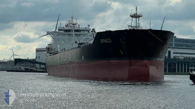
AINAZI
Oil/Chemical Tanker
Current Trip
LTKLJ
| Time Travelled | 3 days |
|---|---|
| Remaining Time | --- |
| Distance Travelled | 807.76 nm |
| Remaining Distance | --- |
| AVG Speed | 12.2 Knots |
| MAX Speed | 16.3 Knots |
| AVG Wind | 14.7 knots |
| MAX Wind | 23 knots |
| MIN Temp | 11.3°C / 52.34°F |
| MAX Temp | 16°C / 60.8°F |
| Dybgang | 7 m |
| Position Modtaget | Nu |
Current Position
| Longitude | 12.00867° |
|---|---|
| Latitude | 56.44617° |
| Status | Under way using engine |
| Fart | 10.5 Knots |
| Kurs | 146° |
| Område | Kattegat |
| Station | T-AIS |
| Position Modtaget | Nu |
Info
Information
The current position of AINAZI is in Kattegat with coordinates 56.44617° / 12.00867° as reported on 2024-05-14 18:23 by AIS to our vessel tracker app. The vessel's current speed is 10.5 Knots
The vessel AINAZI (IMO: 9323405, MMSI: 538002779) is a Oil/Chemical Tanker that was built in 2008 ( 16 år gamle ). It's sailing under the flag of [MH] Marshall Is.
In this page you can find informations about the vessels current position, last detected port calls, and current voyage information. If the vessels is not in coverage by AIS you will find the latest position.
The current position of AINAZI is detected by our AIS receivers and we are not responsible for the reliability of the data. The last position was recorded while the vessel was in Coverage by the Ais receivers of our vessel tracking app.
The current draught of AINAZI as reported by AIS is 7 meters
Weather
| Temperature | 14.9°C / 58.82°F |
|---|---|
| Wind Speed | 14 knots |
| Direction | 122° ESE |
| Pressure | 1016.8 hPa |
| Humidity | 70.3 % |
| Cloud Coverage | 8 % |
Featured Company
Last Port Calls
| Port | Arrival | Departure | Time In Port |
|---|---|---|---|
| 2024-05-09 00:24 | 2024-05-11 18:08 | 2 d | |
| 2024-04-14 23:16 | 2024-04-18 11:08 | 3 d | |
| 2024-03-25 13:54 | 2024-03-31 21:34 | 6 d | |
| 2024-03-17 16:56 | 2024-03-19 01:53 | 1 d | |
| 2024-03-10 08:36 | 2024-03-12 10:32 | 2 d | |
| 2024-03-05 21:42 | 2024-03-05 22:35 | 53 m | |
| 2024-03-04 08:08 | 2024-03-05 20:41 | 1 d | |
| 2024-03-01 10:40 | 2024-03-04 07:29 | 2 d |
Last Trips
| Origin | Departure | Destination | Arrival | Distance | |
|---|---|---|---|---|---|
| 2024-04-18 07:08 | 2024-05-09 01:24 | 4002.66 nm | |||
| 2024-03-31 23:34 | 2024-04-14 19:16 | 3937.12 nm | |||
| 2024-03-19 02:53 | 2024-03-25 14:54 | 95.56 nm | |||
| 2024-03-12 12:32 | 2024-03-17 17:56 | 1379.00 nm | |||
| 2024-03-05 23:35 | 2024-03-10 10:36 | 1158.41 nm | |||
| 2024-03-05 21:41 | 2024-03-05 22:42 | 5.24 nm | |||
| 2024-03-04 08:29 | 2024-03-04 09:08 | 1.67 nm | |||
| 2024-02-17 14:19 | 2024-03-01 11:40 | 3558.53 nm |
Events
| Tid | Hændelsen | Detaljer | Position / Dest | Info |
|---|---|---|---|---|
| 2024-05-14 14:29 | Ændre havområde | Danish part of the Kattegat Swedish part of the Kattegat |
57.14300 / 11.63933
Kattegat
|
Fart: 11 kn Kurs: 177° |
| 2024-05-14 14:23 | Dybgangen er ændret | 7 7.1 |
57.16200 / 11.63867
LTKLJ
|
Fart: 11.1 kn Kurs: 178° |
| 2024-05-14 12:20 | START Sejllads | 3.61 nm, West of VRANGO |
57.57767 / 11.66583
LTKLJ
|
Fart: 3.1 kn Kurs: 210° |
| 2024-05-14 12:16 | Destination er ændret | LTKLJ SEGOT |
57.57933 / 11.66743
LTKLJ
|
Fart: 1 kn Kurs: 216° |
| 2024-05-14 12:16 | ETA er ændret | 2024/07/16 00:00 2024/07/14 04:00 |
57.57933 / 11.66743
LTKLJ
|
Fart: 1 kn Kurs: 216° |
| 2024-05-14 12:06 | Status er ændret | Under way using engine At anchor |
57.58017 / 11.66933
SEGOT
|
Fart: Kurs: 251° |
| 2024-05-14 07:32 | Status er ændret | At anchor Under way using engine |
57.58033 / 11.66483
SEGOT
|
Fart: Kurs: 150° |
| 2024-05-14 07:30 | STOP Sejllads | 3.66 nm, West of VRANGO |
57.58033 / 11.66467
SEGOT
|
Fart: 0.3 kn Kurs: 150° |
| 2024-05-14 05:07 | Ændre havområde | Swedish part of the Kattegat Danish part of the Kattegat |
57.69050 / 11.17167
Kattegat
|
Fart: 10.4 kn Kurs: 119° |
| 2024-05-14 04:05 | Ændre havområde | Danish part of the Kattegat Danish part of the Skaggerak |
57.78433 / 10.88183
Kattegat
|
Fart: 10.5 kn Kurs: 125° |