

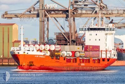
A2B ENERGY
General Cargo

Current Trip
| Trip Time | 18 mins |
|---|---|
| Trip Distance | 0.72 nm |
| AVG Speed | --- |
| MAX Speed | --- |
| Dybgang | 6.3 m |
| AVG Wind | 10 knots |
| MAX Wind | 10 knots |
| MIN Temp | 9°C / 48.2°F |
| MAX Temp | 9.1°C / 48.38°F |
| Position Modtaget | 3 m siden |
Current Position
| Longitude | --- |
|---|---|
| Latitude | --- |
| Status | Moored |
| Fart | |
| Kurs | 92° |
| Område | North Sea |
| Station | T-AIS |
| Position Modtaget | 3 m siden |
Information
The current position of A2B ENERGY is in North Sea with coordinates 51.43239° / 0.68580° as reported on 2025-03-28 16:37 by AIS to our vessel tracker app. The vessel's current speed is 0 Knots and is currently inside the port of THAMESPORT.
The vessel A2B ENERGY (IMO: 9183427, MMSI: 244650437) is a General Cargo that was built in 1998 ( 27 år gamle ). It's sailing under the flag of [NL] Netherlands.
In this page you can find informations about the vessels current position, last detected port calls, and current voyage information. If the vessels is not in coverage by AIS you will find the latest position.
The current position of A2B ENERGY is detected by our AIS receivers and we are not responsible for the reliability of the data. The last position was recorded while the vessel was in Coverage by the Ais receivers of our vessel tracking app.
The current draught of A2B ENERGY as reported by AIS is 6.3 meters
Weather
| Temperature | 10°C / 50°F |
|---|---|
| Wind Speed | 12 knots |
| Direction | 311° NW |
| Pressure | 1011.4 hPa |
| Humidity | 64.9 % |
| Cloud Coverage | 100 % |


Featured Company
Last Port Calls
| Port | Arrival | Departure | Time In Port |
|---|---|---|---|
| 2025-03-28 08:35 | |||
| 2025-03-28 08:11 | 2025-03-28 08:17 | 5 m | |
| 2025-03-27 04:21 | 2025-03-27 19:31 | 15 h | |
| 2025-03-25 19:59 | 2025-03-26 06:57 | 10 h | |
| 2025-03-24 06:35 | 2025-03-25 00:53 | 18 h | |
| 2025-03-23 07:11 | 2025-03-23 16:18 | 9 h | |
| 2025-03-22 06:00 | 2025-03-22 18:22 | 12 h | |
| 2025-03-21 08:34 | 2025-03-21 15:37 | 7 h | |
| 2025-03-16 07:46 | 2025-03-20 15:04 | 4 d | |
| 2025-03-15 08:12 | 2025-03-15 17:13 | 9 h |
Last Trips
| Origin | Departure | Destination | Arrival | Distance | |
|---|---|---|---|---|---|
| 2025-03-28 08:17 | 2025-03-28 08:35 | 0.72 nm | |||
| 2025-03-27 19:31 | 2025-03-28 08:11 | 171.73 nm | |||
| 2025-03-26 06:57 | 2025-03-27 04:21 | 219.19 nm | |||
| 2025-03-25 00:53 | 2025-03-25 19:59 | 218.64 nm | |||
| 2025-03-23 16:18 | 2025-03-24 06:35 | 167.39 nm | |||
| 2025-03-22 18:22 | 2025-03-23 07:11 | 170.98 nm | |||
| 2025-03-21 15:37 | 2025-03-22 06:00 | 170.05 nm | |||
| 2025-03-20 15:04 | 2025-03-21 08:34 | 172.67 nm | |||
| 2025-03-15 17:13 | 2025-03-16 07:46 | 168.50 nm | |||
| 2025-03-14 19:24 | 2025-03-15 08:12 | 172.33 nm |
Events
| Tid | Hændelsen | Detaljer | Position / Dest | Info |
|---|---|---|---|---|
| 2025-03-28 08:47 | Status er ændret | Moored Under way using engine |
51.43242 / .68583
[GB] THAMESPORT
|
Fart: Kurs: 91° |
| 2025-03-28 08:38 | STOP Sejllads |
51.43244 / .68587
[GB] THAMESPORT
|
Fart: 0.1 kn Kurs: 91° |
|
| 2025-03-28 08:35 | Skibe i havn |
|
51.43236 / .68521
[GB] THAMESPORT
|
Fart: 0.6 kn Kurs: 92° |
| 2025-03-28 08:17 | Afsejlet fra sidste havn |
|
51.42932 / .69987
GBTHP
|
Fart: 6.4 kn Kurs: 267° |
| 2025-03-28 08:11 | Skibe i havn |
|
51.43085 / .71505
[GB] THAMESPORT
|
Fart: 6.3 kn Kurs: 243.8° |
| 2025-03-28 01:10 | Ændre havområde | United Kingdom part of the North Sea Dutch part of the North Sea |
52.04917 / 2.67168
North Sea
GBTHP
|
Fart: 12.8 kn Kurs: 261.6° |
| 2025-03-27 21:55 | Destination er ændret | GBTHP GBIMM |
52.04951 / 3.83378
GBTHP
|
Fart: 14.8 kn Kurs: 275.7° |
| 2025-03-27 18:31 | Afsejlet fra sidste havn |
|
51.70603 / 4.61181
GBIMM
|
Fart: 7.9 kn Kurs: 40° |
| 2025-03-27 18:14 | START Sejllads |
51.68206 / 4.59496
[NL] MOERDIJK
|
Fart: 4.4 kn Kurs: 345° |
|
| 2025-03-27 17:31 | Dybgangen er ændret | 6.3 5.1 |
51.68015 / 4.59445
[NL] MOERDIJK
|
Fart: Kurs: 164° |