
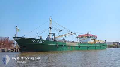
YE157 CORNELIA
Fishing
Current Trip
| Time Travelled | 1 day |
|---|---|
| Remaining Time | --- |
| Distance Travelled | 19.84 nm |
| Remaining Distance | --- |
| AVG Speed | 8.4 Knots |
| MAX Speed | 10.7 Knots |
| AVG Wind | 20.7 knots |
| MAX Wind | 24 knots |
| MIN Temp | 7.4°C / 45.32°F |
| MAX Temp | 8.9°C / 48.02°F |
| Draught | 1.2 m |
| Position Received | 2 h, 19 m ago |
Current Position
| Longitude | 5.28502° |
|---|---|
| Latitude | 53.30579° |
| Status | Moored |
| Speed | 0.1 Knots |
| Course | 239° |
| Area | North Sea |
| Station | T-AIS |
| Position Received | 2 h, 19 m ago |
Info
Information
The current position of YE157 CORNELIA is in North Sea with coordinates 53.30579° / 5.28502° as reported on 2024-04-18 04:24 by AIS to our vessel tracker app. The vessel's current speed is 0.1 Knots
The vessel YE157 CORNELIA (IMO: 9168001, MMSI: 244718000) is a Fishing It's sailing under the flag of [NL] Netherlands.
In this page you can find informations about the vessels current position, last detected port calls, and current voyage information. If the vessels is not in coverage by AIS you will find the latest position.
The current position of YE157 CORNELIA is detected by our AIS receivers and we are not responsible for the reliability of the data. The last position was recorded while the vessel was in Coverage by the Ais receivers of our vessel tracking app.
The current draught of YE157 CORNELIA as reported by AIS is 1.2 meters
Weather
| Temperature | 8.1°C / 46.58°F |
|---|---|
| Wind Speed | 14 knots |
| Direction | 346° NNW |
| Pressure | 1017.2 hPa |
| Humidity | 67.6 % |
| Cloud Coverage | 15 % |
Featured Company
Last Port Calls
| Port | Arrival | Departure | Time In Port |
|---|---|---|---|
| 2024-04-16 11:09 | 2024-04-16 11:25 | 15 m | |
| 2024-04-15 15:22 | 2024-04-15 15:42 | 20 m | |
| 2024-04-11 15:08 | 2024-04-15 04:52 | 3 d | |
| 2024-04-09 16:07 | 2024-04-10 02:13 | 10 h | |
| 2024-04-08 00:08 | 2024-04-08 00:27 | 18 m | |
| 2024-04-03 15:28 | 2024-04-07 22:18 | 4 d | |
| 2024-04-03 03:04 | 2024-04-03 03:14 | 10 m | |
| 2024-04-02 06:30 | 2024-04-02 06:49 | 19 m | |
| 2024-03-27 17:40 | 2024-03-28 06:02 | 12 h | |
| 2024-03-25 16:42 | 2024-03-25 17:02 | 20 m |
Most Visited Ports (Last year)
| Port | Arrivals | |
|---|---|---|
| 110 | ||
| 25 | ||
| 21 | ||
| 12 | ||
| 12 | ||
| 9 |
Last Trips
| Origin | Departure | Destination | Arrival | Distance | |
|---|---|---|---|---|---|
| 2024-04-15 17:42 | 2024-04-16 13:09 | 1.66 nm | |||
| 2024-04-15 06:52 | 2024-04-15 17:22 | 31.66 nm | |||
| 2024-04-10 04:13 | 2024-04-11 17:08 | 131.07 nm | |||
| 2024-04-08 02:27 | 2024-04-09 18:07 | 185.71 nm | |||
| 2024-04-08 00:18 | 2024-04-08 02:08 | 16.44 nm | |||
| 2024-04-03 05:14 | 2024-04-03 17:28 | 74.84 nm | |||
| 2024-04-02 08:49 | 2024-04-03 05:04 | 110.75 nm | |||
| 2024-03-28 07:02 | 2024-04-02 08:30 | 1.66 nm | |||
| 2024-03-25 18:02 | 2024-03-27 18:40 | 56.65 nm | |||
| 2024-03-25 15:55 | 2024-03-25 17:42 | 1.46 nm |
Events
| Time | Event | Details | Position / Dest | Info |
|---|---|---|---|---|
| 2024-04-18 04:24 | OUT of Coverage |
53.30579 / 5.28502
North Sea
YERSEKE
|
Speed: 0.1 kn Course: 151° |
|
| 2024-04-18 04:19 | STOP Moving | 3.85 nm, South East of TERSCHELLING |
53.30559 / 5.28438
YERSEKE
|
Speed: 0.3 kn Course: 241° |
| 2024-04-18 04:17 | START Moving | 3.92 nm, South East of TERSCHELLING |
53.30473 / 5.28571
YERSEKE
|
Speed: 6 kn Course: 260° |
| 2024-04-17 19:32 | IN Coverage |
53.30416 / 5.28884
North Sea
YERSEKE
|
Speed: Course: 273° |
|
| 2024-04-17 04:43 | OUT of Coverage |
53.31286 / 5.30612
North Sea
YERSEKE
|
Speed: Course: 354° |
|
| 2024-04-17 04:32 | STOP Moving | 4.08 nm, South East of TERSCHELLING |
53.31289 / 5.30608
YERSEKE
|
Speed: 0.3 kn Course: 263° |
| 2024-04-17 04:30 | START Moving | 4.14 nm, South East of TERSCHELLING |
53.31324 / 5.30855
YERSEKE
|
Speed: 3.3 kn Course: 255° |
| 2024-04-17 04:27 | STOP Moving | 4.22 nm, South East of TERSCHELLING |
53.31366 / 5.31202
YERSEKE
|
Speed: 0.1 kn Course: 297° |
| 2024-04-17 04:19 | START Moving | 4.02 nm, South East of TERSCHELLING |
53.30531 / 5.29145
YERSEKE
|
Speed: 7.1 kn Course: 67° |
| 2024-04-16 18:39 | IN Coverage |
53.30397 / 5.28914
North Sea
YERSEKE
|
Speed: 0.2 kn Course: 86° |