
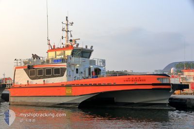
UMO MISTRAL
Crew Boat
Current Trip
| Trip Time | 43 days |
|---|---|
| Trip Distance | 445.40 nm |
| AVG Speed | 11.2 Knots |
| MAX Speed | 16.9 Knots |
| Draught | 2 m |
| AVG Wind | 17.7 knots |
| MAX Wind | 39.8 knots |
| MIN Temp | 19.5°C / 67.1°F |
| MAX Temp | 28.8°C / 83.84°F |
| Position Received | 7 d ago |
Current Position
| Longitude | --- |
|---|---|
| Latitude | --- |
| Status | Under way using engine |
| Speed | 11.2 Knots |
| Course | 202.3° |
| Area | Eastern China Sea |
| Station | T-AIS |
| Position Received | 7 d ago |
Info
Information
The current position of UMO MISTRAL is in Eastern China Sea with coordinates 25.00292° / 122.09171° as reported on 2025-11-30 03:33 by AIS to our vessel tracker app. The vessel's current speed is 11.2 Knots and is currently inside the port of SUAO.
The vessel UMO MISTRAL (IMO: 9681302, MMSI: 416008897) is a Crew Boat that was built in 2013 ( 12 years old ). It's sailing under the flag of [TW] Taiwan.
In this page you can find informations about the vessels current position, last detected port calls, and current voyage information. If the vessels is not in coverage by AIS you will find the latest position.
The current position of UMO MISTRAL is detected by our AIS receivers and we are not responsible for the reliability of the data. The last position was recorded while the vessel was in Coverage by the Ais receivers of our vessel tracking app.
The current draught of UMO MISTRAL as reported by AIS is 2 meters
Weather
| Temperature | 14°C / 57.2°F |
|---|---|
| Wind Speed | 3 knots |
| Direction | 281° W |
| Pressure | 1019.5 hPa |
| Humidity | 86.2 % |
| Cloud Coverage | --- |
Featured Company
Last Trips
Events
| Time | Event | Details | Position / Dest | Info |
|---|---|---|---|---|
| 2025-11-30 06:47 | STOP Moving |
24.59667 / 121.85667
[TW] SUAO
|
Speed: Course: -1° |
|
| 2025-11-30 06:21 | PORT ARRIVAL |
|
24.59400 / 121.87657
[TW] SUAO
|
Speed: 10.1 kn Course: 303° |
| 2025-11-30 03:38 | Status Changed | Default Under way using engine |
24.98833 / 122.08667
JIGJUN
|
Speed: 11.2 kn Course: 202.3° |
| 2025-11-30 03:33 | Status Changed | Under way using engine Default |
25.00292 / 122.09171
JIGJUN
|
Speed: 10 kn Course: 176° |
| 2025-11-30 03:33 | OUT of Coverage |
25.00292 / 122.09171
Eastern China Sea
|
Speed: 11.2 kn Course: 202.3° |
|
| 2025-11-30 02:59 | Status Changed | Default Under way using engine |
25.10167 / 122.05500
JIGJUN
|
Speed: 13.7 kn Course: 133° |
| 2025-11-30 01:08 | Destination Changed | JIGJUN JIANG JUN FISH PORT |
25.30577 / 121.71358
JIGJUN
|
Speed: 12.3 kn Course: 127.7° |
| 2025-11-30 01:08 | ETA Changed | 2026/10/18 06:00 2025/10/10 04:00 |
25.30577 / 121.71358
JIGJUN
|
Speed: 12.3 kn Course: 127.7° |
| 2025-11-30 00:44 | Change Sea Area | Taiwanese part of the Eastern China Sea Taiwanese part of the South China Sea |
25.35639 / 121.63849
Eastern China Sea
|
Speed: 12.9 kn Course: 114.3° |
| 2025-11-30 00:44 | Status Changed | Under way using engine Default |
25.35639 / 121.63849
JIANG JUN FISH PORT
|
Speed: 12 kn Course: 116° |