
TRITON WIND I
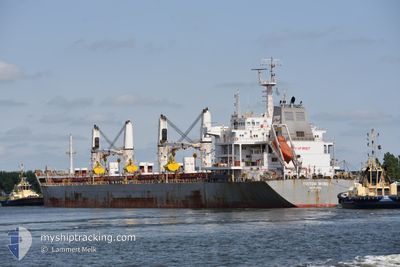
Bulk Carrier
Current Trip
| Time Travelled | 5 days |
|---|---|
| Remaining Time | --- |
| Distance Travelled | 228.49 nm |
| Remaining Distance | --- |
| AVG Speed | 10.3 Knots |
| MAX Speed | 12.3 Knots |
| AVG Wind | 6.7 knots |
| MAX Wind | 12 knots |
| MIN Temp | 26.1°C / 78.98°F |
| MAX Temp | 29.5°C / 85.1°F |
| Draught | 5.6 m |
| Position Received | 5 m ago |
Current Position
| Longitude | -35.74154° |
|---|---|
| Latitude | -9.70539° |
| Status | At anchor |
| Speed | 0.1 Knots |
| Course | 129° |
| Area | South Atlantic Ocean |
| Station | T-AIS |
| Position Received | 5 m ago |
Info
Information
The current position of TRITON WIND I is in South Atlantic Ocean with coordinates -9.70539° / -35.74154° as reported on 2024-04-25 18:07 by AIS to our vessel tracker app. The vessel's current speed is 0.1 Knots
The vessel TRITON WIND I (IMO: 9621003, MMSI: 636017611) is a Bulk Carrier that was built in 2013 ( 11 years old ). It's sailing under the flag of [LR] Liberia.
In this page you can find informations about the vessels current position, last detected port calls, and current voyage information. If the vessels is not in coverage by AIS you will find the latest position.
The current position of TRITON WIND I is detected by our AIS receivers and we are not responsible for the reliability of the data. The last position was recorded while the vessel was in Coverage by the Ais receivers of our vessel tracking app.
The current draught of TRITON WIND I as reported by AIS is 5.6 meters
Weather
| Temperature | 28.8°C / 83.84°F |
|---|---|
| Wind Speed | 7 knots |
| Direction | 125° SE |
| Pressure | 1010 hPa |
| Humidity | 72.1 % |
| Cloud Coverage | 3 % |
Featured Company
Last Port Calls
| Port | Arrival | Departure | Time In Port |
|---|---|---|---|
| 2024-04-15 19:31 | 2024-04-20 13:13 | 4 d | |
| 2024-04-08 19:10 | 2024-04-15 10:58 | 6 d | |
| 2024-03-28 03:01 | 2024-03-29 04:49 | 1 d | |
| 2024-03-24 16:33 | 2024-03-28 01:41 | 3 d | |
| 2024-02-19 20:12 | 2024-03-02 12:16 | 11 d | |
| 2024-02-01 12:53 |
Most Visited Ports (Last year)
| Port | Arrivals | |
|---|---|---|
| 2 | ||
| 2 | ||
| 2 | ||
| 2 | ||
| 1 | ||
| 1 |
Last Trips
| Origin | Departure | Destination | Arrival | Distance | |
|---|---|---|---|---|---|
| 2024-04-15 07:58 | 2024-04-15 16:31 | 84.79 nm | |||
| 2024-03-29 01:49 | 2024-04-08 16:10 | 2563.61 nm | |||
| 2024-03-27 22:41 | 2024-03-28 00:01 | 9.77 nm | |||
| 2024-03-02 13:16 | 2024-03-24 13:33 | 4476.36 nm | |||
| 2024-02-01 09:53 | 2024-02-19 21:12 | 4307.44 nm |
Events
| Time | Event | Details | Position / Dest | Info |
|---|---|---|---|---|
| 2024-04-25 17:31 | Status Changed | At anchor Default |
-9.70532 / -35.74152
BR MACEIO
|
Speed: 0.1 kn Course: 132° |
| 2024-04-25 17:22 | Status Changed | Default At anchor |
-9.70533 / -35.74153
BR MACEIO
|
Speed: Course: 141° |
| 2024-04-25 16:01 | Status Changed | At anchor Default |
-9.70531 / -35.74148
BR MACEIO
|
Speed: Course: -1° |
| 2024-04-25 15:53 | Status Changed | Default At anchor |
-9.70500 / -35.74166
BR MACEIO
|
Speed: 0.2 kn Course: 127° |
| 2024-04-25 15:31 | Status Changed | At anchor Default |
-9.70561 / -35.74171
BR MACEIO
|
Speed: Course: -1° |
| 2024-04-25 15:29 | Status Changed | Default At anchor |
-9.70500 / -35.74166
BR MACEIO
|
Speed: 0.2 kn Course: 127° |
| 2024-04-25 14:42 | Status Changed | At anchor Default |
-9.70561 / -35.74171
BR MACEIO
|
Speed: Course: -1° |
| 2024-04-25 14:41 | Status Changed | Default At anchor |
-9.70500 / -35.74166
BR MACEIO
|
Speed: 0.2 kn Course: 118° |
| 2024-04-25 14:30 | Status Changed | At anchor Default |
-9.70573 / -35.74180
BR MACEIO
|
Speed: Course: -1° |
| 2024-04-25 14:29 | Status Changed | Default At anchor |
-9.70500 / -35.74166
BR MACEIO
|
Speed: 0.1 kn Course: 109° |