
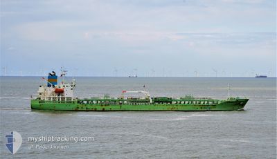
SUNRISE RAY
Tanker B
Current Trip
MX VER
| Time Travelled | 16 h, 4 mins |
|---|---|
| Remaining Time | --- |
| Distance Travelled | 170.36 nm |
| Remaining Distance | --- |
| AVG Speed | 11.3 Knots |
| MAX Speed | 12.2 Knots |
| AVG Wind | 12.7 knots |
| MAX Wind | 15.4 knots |
| MIN Temp | 24.9°C / 76.82°F |
| MAX Temp | 27.3°C / 81.14°F |
| Draught | 7 m |
| Position Received | 2 d ago |
Current Position
| Longitude | -92.88752° |
|---|---|
| Latitude | 22.74557° |
| Status | Under way using engine |
| Speed | 13.7 Knots |
| Course | 216.3° |
| Area | Gulf of Mexico |
| Station | T-AIS |
| Position Received | 2 d ago |
Info
Information
The current position of SUNRISE RAY is in Gulf of Mexico with coordinates 22.74557° / -92.88752° as reported on 2024-04-17 06:59 by AIS to our vessel tracker app. The vessel's current speed is 13.7 Knots
The vessel SUNRISE RAY (IMO: 9829679, MMSI: 636019179) is a Tanker B It's sailing under the flag of [LR] Liberia.
In this page you can find informations about the vessels current position, last detected port calls, and current voyage information. If the vessels is not in coverage by AIS you will find the latest position.
The current position of SUNRISE RAY is detected by our AIS receivers and we are not responsible for the reliability of the data. The last position was recorded while the vessel was in Coverage by the Ais receivers of our vessel tracking app.
The current draught of SUNRISE RAY as reported by AIS is 7 meters
Weather
| Temperature | 24.9°C / 76.82°F |
|---|---|
| Wind Speed | 13 knots |
| Direction | 75° ENE |
| Pressure | 1011.8 hPa |
| Humidity | 90.6 % |
| Cloud Coverage | 6 % |
Featured Company
Last Port Calls
| Port | Arrival | Departure | Time In Port |
|---|---|---|---|
| 2024-04-18 05:29 | 2024-04-18 19:24 | 13 h | |
| 2024-04-13 23:16 | 2024-04-15 14:45 | 1 d | |
| 2024-04-07 19:16 | 2024-04-09 00:53 | 1 d | |
| 2024-03-24 09:32 | 2024-03-24 16:04 | 6 h | |
| 2024-03-22 10:55 | 2024-03-23 13:03 | 1 d | |
| 2024-03-18 17:01 | 2024-03-19 21:42 | 1 d | |
| 2024-03-16 02:18 | 2024-03-16 17:44 | 15 h | |
| 2024-03-12 22:38 | 2024-03-14 22:08 | 1 d | |
| 2024-02-05 21:43 |
Most Visited Ports (Last year)
| Port | Arrivals | |
|---|---|---|
| 6 | ||
| 3 | ||
| 3 | ||
| 2 | ||
| 2 | ||
| 2 |
Last Trips
| Origin | Departure | Destination | Arrival | Distance | |
|---|---|---|---|---|---|
| 2024-04-15 09:45 | 2024-04-18 00:29 | 799.06 nm | |||
| 2024-04-08 20:53 | 2024-04-13 18:16 | 1365.60 nm | |||
| 2024-03-24 17:04 | 2024-04-07 15:16 | 4001.51 nm | |||
| 2024-03-23 14:03 | 2024-03-24 10:32 | 252.60 nm | |||
| 2024-03-19 22:42 | 2024-03-22 11:55 | 198.83 nm | |||
| 2024-03-16 18:44 | 2024-03-18 18:01 | 586.75 nm | |||
| 2024-03-14 22:08 | 2024-03-16 03:18 | 292.81 nm | |||
| 2024-02-06 00:43 | 2024-03-12 22:38 | 3508.00 nm |
Events
| Time | Event | Details | Position / Dest | Info |
|---|---|---|---|---|
| 2024-04-18 19:24 | PORT DEPARTURE |
|
19.19096 / -96.03831
MX VER
|
Speed: 5 kn Course: -1° |
| 2024-04-18 19:14 | START Moving |
19.20667 / -96.13333
[MX] VERACRUZ
|
Speed: 5 kn Course: -1° |
|
| 2024-04-18 05:59 | STOP Moving |
19.21333 / -96.13666
[MX] VERACRUZ
|
Speed: Course: -1° |
|
| 2024-04-18 05:29 | PORT ARRIVAL |
|
19.21333 / -96.13666
[MX] VERACRUZ
|
Speed: 9 kn Course: 271° |
| 2024-04-17 07:09 | Status Changed | Default Under way using engine |
22.71377 / -92.91425
MX VER
|
Speed: 13.7 kn Course: 216.3° |
| 2024-04-17 06:59 | Status Changed | Under way using engine Default |
22.74557 / -92.88752
MX VER
|
Speed: 13.6 kn Course: 218° |
| 2024-04-17 06:59 | OUT of Coverage |
22.74557 / -92.88752
Gulf of Mexico
MX VER
|
Speed: 13.7 kn Course: 216.3° |
|
| 2024-04-17 06:45 | IN Coverage |
22.74557 / -92.88752
Gulf of Mexico
MX VER
|
Speed: 13.7 kn Course: 216.3° |
|
| 2024-04-17 01:38 | Status Changed | Default Under way using engine |
23.69167 / -92.01667
MX VER
|
Speed: 13.4 kn Course: 220.8° |
| 2024-04-17 01:36 | OUT of Coverage |
23.69541 / -92.01487
Gulf of Mexico
MX VER
|
Speed: 13.4 kn Course: 220.8° |