
KAILI
General Cargo
Current Trip
| Time Travelled | 1 day |
|---|---|
| Remaining Time | --- |
| Distance Travelled | 465.17 nm |
| Remaining Distance | --- |
| AVG Speed | 11.1 Knots |
| MAX Speed | 12.5 Knots |
| AVG Wind | 10.5 knots |
| MAX Wind | 20.1 knots |
| MIN Temp | -0.7°C / 30.74°F |
| MAX Temp | 3.7°C / 38.66°F |
| Draught | 5.3 m |
| Position Received | Now |
Current Position
| Longitude | 15.17974° |
|---|---|
| Latitude | 55.62821° |
| Status | Under way using engine |
| Speed | 12.2 Knots |
| Course | 239.5° |
| Area | Baltic Sea |
| Station | T-AIS |
| Position Received | Now |
Info
Information
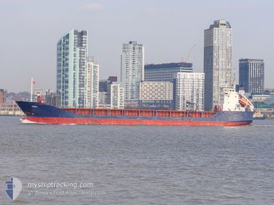
The current position of KAILI is in Baltic Sea with coordinates 55.62821° / 15.17974° as reported on 2024-04-19 14:17 by AIS to our vessel tracker app. The vessel's current speed is 12.2 Knots and is heading at the port of ZWIJNDRECHT. The estimated time of arrival as calculated by MyShipTracking vessel tracking app is 2024-04-21 23:00 LT
The vessel KAILI (IMO: 9114737, MMSI: 256295000) is a General Cargo that was built in 1996 ( 28 years old ). It's sailing under the flag of [MT] Malta.
In this page you can find informations about the vessels current position, last detected port calls, and current voyage information. If the vessels is not in coverage by AIS you will find the latest position.
The current position of KAILI is detected by our AIS receivers and we are not responsible for the reliability of the data. The last position was recorded while the vessel was in Coverage by the Ais receivers of our vessel tracking app.
The current draught of KAILI as reported by AIS is 5.3 meters
Weather
| Temperature | 3.4°C / 38.12°F |
|---|---|
| Wind Speed | 20 knots |
| Direction | 76° ENE |
| Pressure | 1003.7 hPa |
| Humidity | 84.1 % |
| Cloud Coverage | 100 % |
Featured Company
Last Port Calls
| Port | Arrival | Departure | Time In Port |
|---|---|---|---|
| 2024-04-17 13:20 | 2024-04-17 22:49 | 9 h | |
| 2024-04-11 18:24 | 2024-04-16 10:30 | 4 d | |
| 2024-04-08 06:24 | 2024-04-10 15:27 | 2 d | |
| 2024-04-06 02:09 | 2024-04-06 02:21 | 11 m | |
| 2024-04-04 20:46 | 2024-04-06 01:20 | 1 d | |
| 2024-04-04 19:55 | 2024-04-04 19:59 | 3 m | |
| 2024-04-02 23:09 | 2024-04-04 07:49 | 1 d | |
| 2024-03-20 11:42 | 2024-03-20 11:48 | 6 m | |
| 2024-03-19 15:37 | 2024-03-20 10:22 | 18 h | |
| 2024-03-19 14:31 | 2024-03-19 14:43 | 11 m |
Last Trips
| Origin | Departure | Destination | Arrival | Distance | |
|---|---|---|---|---|---|
| 2024-04-16 12:30 | 2024-04-17 16:20 | 335.62 nm | |||
| 2024-04-10 17:27 | 2024-04-11 20:24 | 303.90 nm | |||
| 2024-04-06 05:21 | 2024-04-08 08:24 | 525.90 nm | |||
| 2024-04-06 04:20 | 2024-04-06 05:09 | 3.28 nm | |||
| 2024-04-04 22:59 | 2024-04-04 23:46 | 4.42 nm | |||
| 2024-04-04 10:49 | 2024-04-04 22:55 | 130.82 nm | |||
| 2024-03-20 12:48 | 2024-04-03 02:09 | 1503.25 nm | |||
| 2024-03-20 11:22 | 2024-03-20 12:42 | 6.34 nm | |||
| 2024-03-19 15:43 | 2024-03-19 16:37 | 8.15 nm | |||
| 2024-03-15 21:18 | 2024-03-19 15:31 | 743.41 nm |
Events
| Time | Event | Details | Position / Dest | Info |
|---|---|---|---|---|
| 2024-04-19 14:07 | Detected in Sea | Danish part of the Kattegat |
55.64554 / 15.23195
Kattegat
ZWIJNDRECHT
|
Speed: 12.3 kn Course: 240.2° |
| 2024-04-19 09:12 | Change Sea Area | Swedish part of the Baltic Sea Finnish part of the Baltic Sea |
56.17529 / 16.77190
Baltic Sea
ZWIJNDRECHT
|
Speed: 12.2 kn Course: 234.1° |
| 2024-04-19 09:12 | IN Coverage |
56.17529 / 16.77190
Baltic Sea
ZWIJNDRECHT
|
Speed: 12.2 kn Course: 234.1° |
|
| 2024-04-18 10:51 | Status Changed | Default Under way using engine |
59.41167 / 22.33833
ZWIJNDRECHT
|
Speed: 12.4 kn Course: 256.6° |
| 2024-04-18 09:53 | OUT of Coverage |
59.51552 / 22.66486
Baltic Sea
ZWIJNDRECHT
|
Speed: 12.4 kn Course: 256.6° |
|
| 2024-04-18 08:44 | Detected in Sea | Finnish part of the Baltic Sea |
59.58173 / 23.10579
Baltic Sea
ZWIJNDRECHT
|
Speed: 12.2 kn Course: 252.9° |
| 2024-04-18 07:33 | Status Changed | Under way using engine Default |
59.65075 / 23.56225
ZWIJNDRECHT
|
Speed: 11.9 kn Course: 256° |
| 2024-04-18 07:33 | IN Coverage |
59.65075 / 23.56225
Gulf of Finland
ZWIJNDRECHT
|
Speed: 12.1 kn Course: 249.4° |
|
| 2024-04-18 05:36 | OUT of Coverage |
59.76611 / 24.30033
Gulf of Finland
ZWIJNDRECHT
|
Speed: 12.2 kn Course: 253.5° |
|
| 2024-04-18 04:39 | Change Sea Area | Finnish part of the Gulf of Finland Estonian part of the Gulf of Finland |
59.80368 / 24.65874
Gulf of Finland
ZWIJNDRECHT
|
Speed: 11.1 kn Course: 260.8° |