
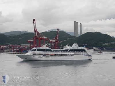
INSIGNIA
Passengers Ship
Current Trip
| Time Travelled | 12 h, 25 mins |
|---|---|
| Remaining Time | 18 h, 33 mins |
| Distance Travelled | 132.92 nm |
| Remaining Distance | 234.27 nm |
| AVG Speed | 11.7 Knots |
| MAX Speed | 14.4 Knots |
| AVG Wind | 3.8 knots |
| MAX Wind | 7.1 knots |
| MIN Temp | 29.1°C / 84.38°F |
| MAX Temp | 30.4°C / 86.72°F |
| Draught | 6 m |
| Position Received | 34 m ago |
Current Position
| Longitude | 99.73280° |
|---|---|
| Latitude | 6.25693° |
| Status | Moored |
| Speed | 0.1 Knots |
| Course | 288° |
| Area | Malacca Strait |
| Station | T-AIS |
| Position Received | 34 m ago |
Info
Information
The current position of INSIGNIA is in Malacca Strait with coordinates 6.25693° / 99.73280° as reported on 2024-04-25 22:30 by AIS to our vessel tracker app. The vessel's current speed is 0.1 Knots and is heading at the port of PORT KLANG. The estimated time of arrival as calculated by MyShipTracking vessel tracking app is 2024-04-26 17:38 LT
The vessel INSIGNIA (IMO: 9156462, MMSI: 538001663) is a Passengers Ship that was built in 1998 ( 26 years old ). It's sailing under the flag of [MH] Marshall Is.
In this page you can find informations about the vessels current position, last detected port calls, and current voyage information. If the vessels is not in coverage by AIS you will find the latest position.
The current position of INSIGNIA is detected by our AIS receivers and we are not responsible for the reliability of the data. The last position was recorded while the vessel was in Coverage by the Ais receivers of our vessel tracking app.
The current draught of INSIGNIA as reported by AIS is 6 meters
Weather
| Temperature | 29.4°C / 84.92°F |
|---|---|
| Wind Speed | 1 knots |
| Direction | 125° SE |
| Pressure | 1007.2 hPa |
| Humidity | 71.2 % |
| Cloud Coverage | 100 % |
Featured Company
Last Port Calls
| Port | Arrival | Departure | Time In Port |
|---|---|---|---|
| 2024-04-25 01:20 | 2024-04-25 10:40 | 9 h | |
| 2024-04-23 23:52 | 2024-04-24 11:24 | 11 h | |
| 2024-04-21 23:31 | 2024-04-23 10:01 | 1 d | |
| 2024-04-18 02:11 | 2024-04-19 09:33 | 1 d | |
| 2024-04-07 07:33 | 2024-04-08 13:38 | 1 d | |
| 2024-03-31 22:21 | 2024-04-01 10:06 | 11 h | |
| 2024-03-30 22:22 | 2024-03-31 08:28 | 10 h | |
| 2024-03-30 01:14 | 2024-03-30 11:12 | 9 h | |
| 2024-03-28 20:52 | 2024-03-29 07:49 | 10 h | |
| 2024-03-27 02:36 | 2024-03-28 09:17 | 1 d |
Last Trips
| Origin | Departure | Destination | Arrival | Distance | |
|---|---|---|---|---|---|
| 2024-04-24 19:24 | 2024-04-25 09:20 | 216.30 nm | |||
| 2024-04-23 18:01 | 2024-04-24 07:52 | 200.28 nm | |||
| 2024-04-19 16:33 | 2024-04-22 07:31 | 906.14 nm | |||
| 2024-04-08 21:38 | 2024-04-18 09:11 | 2103.13 nm | |||
| 2024-04-01 19:06 | 2024-04-07 15:33 | 1407.33 nm | |||
| 2024-03-31 17:28 | 2024-04-01 07:21 | 151.58 nm | |||
| 2024-03-30 20:12 | 2024-03-31 07:22 | 159.16 nm | |||
| 2024-03-29 16:49 | 2024-03-30 10:14 | 239.92 nm | |||
| 2024-03-28 18:17 | 2024-03-29 05:52 | 169.27 nm | |||
| 2024-03-26 16:11 | 2024-03-27 11:36 | 307.76 nm |
Events
| Time | Event | Details | Position / Dest | Info |
|---|---|---|---|---|
| 2024-04-25 22:34 | Status Changed | Default Moored |
6.25695 / 99.73280
PORT KLANG
|
Speed: 0.1 kn Course: 288° |
| 2024-04-25 22:30 | Status Changed | Moored Default |
6.25693 / 99.73280
PORT KLANG
|
Speed: Course: 288° |
| 2024-04-25 22:25 | Status Changed | Default Under way using engine |
6.25677 / 99.73260
PORT KLANG
|
Speed: 1.3 kn Course: 325° |
| 2024-04-25 22:25 | STOP Moving | 7.28 nm, West of LANGKAWI |
6.25677 / 99.73260
PORT KLANG
|
Speed: 0.2 kn Course: 287° |
| 2024-04-25 21:31 | Change Sea Area | Malaysian part of the Malacca Strait Malaysian part of the Singapore Strait |
6.24818 / 99.61743
Malacca Strait
|
Speed: 13.2 kn Course: 71.4° |
| 2024-04-25 21:31 | Status Changed | Under way using engine Default |
6.24818 / 99.61743
PORT KLANG
|
Speed: 12.4 kn Course: 69° |
| 2024-04-25 21:16 | IN Coverage |
6.24818 / 99.61743
Malacca Strait
|
Speed: 13.2 kn Course: 71.4° |
|
| 2024-04-25 10:40 | PORT DEPARTURE |
|
5.45505 / 100.34598
PORT KLANG
|
Speed: 12 kn Course: 357° |
| 2024-04-25 10:32 | START Moving |
5.42842 / 100.34717
[MY] PENANG
|
Speed: 10 kn Course: 4° |
|
| 2024-04-25 01:20 | STOP Moving |
5.42075 / 100.34652
[MY] PENANG
|
Speed: 0.1 kn Course: 351° |