
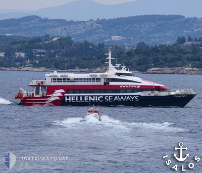
FLYING CAT 5
High speed craft
Current Trip
| Trip Time | 1 h, 10 mins |
|---|---|
| Trip Distance | 28.89 nm |
| AVG Speed | 24.3 Knots |
| MAX Speed | 26.1 Knots |
| Draught | 1.7 m |
| AVG Wind | 10.2 knots |
| MAX Wind | 11.6 knots |
| MIN Temp | 19.9°C / 67.82°F |
| MAX Temp | 20.6°C / 69.08°F |
| Position Received | 1 m ago |
Current Position
| Longitude | --- |
|---|---|
| Latitude | --- |
| Status | Under way using engine |
| Speed | 80 Knots |
| Course | 172° |
| Area | Aegean Sea |
| Station | T-AIS |
| Position Received | 1 m ago |
Info
Information
The current position of FLYING CAT 5 is in Aegean Sea with coordinates 37.94391° / 23.64319° as reported on 2024-11-23 09:29 by AIS to our vessel tracker app. The vessel's current speed is 80 Knots and is currently inside the port of PIRAEUS.
The vessel FLYING CAT 5 (IMO: 9134543, MMSI: 237836900) is a High speed craft that was built in 1996 ( 28 years old ). It's sailing under the flag of [GR] Greece.
In this page you can find informations about the vessels current position, last detected port calls, and current voyage information. If the vessels is not in coverage by AIS you will find the latest position.
The current position of FLYING CAT 5 is detected by our AIS receivers and we are not responsible for the reliability of the data. The last position was recorded while the vessel was in Coverage by the Ais receivers of our vessel tracking app.
The current draught of FLYING CAT 5 as reported by AIS is 1.7 meters
Weather
| Temperature | 17.6°C / 63.68°F |
|---|---|
| Wind Speed | 17 knots |
| Direction | 315° NW |
| Pressure | 1014.8 hPa |
| Humidity | 37.4 % |
| Cloud Coverage | 21 % |
Featured Company
Last Port Calls
| Port | Arrival | Departure | Time In Port |
|---|---|---|---|
| 2024-11-22 14:48 | |||
| 2024-11-22 13:28 | 2024-11-22 13:38 | 10 m | |
| 2024-11-22 12:39 | 2024-11-22 12:50 | 10 m | |
| 2024-11-22 12:11 | 2024-11-22 12:17 | 6 m | |
| 2024-11-22 11:32 | 2024-11-22 11:47 | 15 m | |
| 2024-11-22 10:39 | 2024-11-22 11:24 | 45 m | |
| 2024-11-22 09:53 | 2024-11-22 10:00 | 6 m | |
| 2024-11-22 09:10 | 2024-11-22 09:21 | 11 m | |
| 2024-11-22 08:26 | 2024-11-22 08:38 | 12 m | |
| 2024-11-21 14:56 | 2024-11-22 07:11 | 16 h |
Last Trips
| Origin | Departure | Destination | Arrival | Distance | |
|---|---|---|---|---|---|
| 2024-11-22 15:38 | 2024-11-22 16:48 | 28.89 nm | |||
| 2024-11-22 14:50 | 2024-11-22 15:28 | 12.74 nm | |||
| 2024-11-22 14:17 | 2024-11-22 14:39 | 9.33 nm | |||
| 2024-11-22 14:17 | 2024-11-22 14:11 | 9.33 nm | |||
| 2024-11-22 13:24 | 2024-11-22 13:32 | 2.65 nm | |||
| 2024-11-22 12:00 | 2024-11-22 12:39 | 12.17 nm | |||
| 2024-11-22 11:21 | 2024-11-22 11:53 | 9.95 nm | |||
| 2024-11-22 10:38 | 2024-11-22 11:10 | 12.42 nm | |||
| 2024-11-22 09:11 | 2024-11-22 10:26 | 29.39 nm | |||
| 2024-11-21 15:40 | 2024-11-21 16:56 | 29.60 nm |
Events
| Time | Event | Details | Position / Dest | Info |
|---|---|---|---|---|
| 2024-11-23 05:26 | IN Coverage |
37.94390 / 23.64319
Aegean Sea
[GR] PIRAEUS
|
Speed: Course: 10.9° |
|
| 2024-11-22 16:19 | OUT of Coverage |
37.94390 / 23.64318
Aegean Sea
[GR] PIRAEUS
|
Speed: Course: 221.7° |
|
| 2024-11-22 14:57 | STOP Moving |
37.94391 / 23.64319
[GR] PIRAEUS
|
Speed: 0.3 kn Course: 174° |
|
| 2024-11-22 14:48 | PORT ARRIVAL |
|
37.93754 / 23.62093
[GR] PIRAEUS
|
Speed: 11.8 kn Course: 59° |
| 2024-11-22 13:38 | PORT DEPARTURE |
|
37.50502 / 23.44504
ARGOSARONIKOS
|
Speed: 10.9 kn Course: 327° |
| 2024-11-22 13:36 | START Moving |
37.50039 / 23.44981
[GR] POROS
|
Speed: 8.5 kn Course: 326° |
|
| 2024-11-22 13:28 | STOP Moving |
37.49884 / 23.45154
[GR] POROS
|
Speed: Course: 315° |
|
| 2024-11-22 13:28 | PORT ARRIVAL |
|
37.49884 / 23.45154
[GR] POROS
|
Speed: 0.6 kn Course: 511° |
| 2024-11-22 12:50 | START Moving | 0.18 nm, North of HYDRA |
37.35433 / 23.46668
ARGOSARONIKOS
|
Speed: 12.9 kn Course: 36° |
| 2024-11-22 12:50 | PORT DEPARTURE |
|
37.35433 / 23.46668
ARGOSARONIKOS
|
Speed: 2.3 kn Course: 118° |