
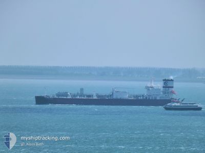
CLIPPER ENYO
Tanker D
Current Trip
| Time Travelled | 17 days |
|---|---|
| Remaining Time | --- |
| Distance Travelled | 5753.75 nm |
| Remaining Distance | 23.44 nm |
| AVG Speed | 13.7 Knots |
| MAX Speed | 18.1 Knots |
| AVG Wind | 18.8 knots |
| MAX Wind | 38 knots |
| MIN Temp | 3.2°C / 37.76°F |
| MAX Temp | 28.8°C / 83.84°F |
| Draught | 8.8 m |
| Position Received | 2 m ago |
Current Position
| Longitude | 11.34779° |
|---|---|
| Latitude | 57.93977° |
| Status | At anchor |
| Speed | |
| Course | 98° |
| Area | Skaggerak |
| Station | T-AIS |
| Position Received | 2 m ago |
Info
Information
The current position of CLIPPER ENYO is in Skaggerak with coordinates 57.93977° / 11.34779° as reported on 2024-04-19 03:49 by AIS to our vessel tracker app. The vessel's current speed is 0 Knots and is heading at the port of STENUNGSUND. The estimated time of arrival as calculated by MyShipTracking vessel tracking app is 2024-04-18 15:30 LT
The vessel CLIPPER ENYO (IMO: 9827217, MMSI: 257066990) is a Tanker D It's sailing under the flag of [NO] Norway.
In this page you can find informations about the vessels current position, last detected port calls, and current voyage information. If the vessels is not in coverage by AIS you will find the latest position.
The current position of CLIPPER ENYO is detected by our AIS receivers and we are not responsible for the reliability of the data. The last position was recorded while the vessel was in Coverage by the Ais receivers of our vessel tracking app.
The current draught of CLIPPER ENYO as reported by AIS is 8.8 meters
Weather
| Temperature | 3.4°C / 38.12°F |
|---|---|
| Wind Speed | 16 knots |
| Direction | 105° ESE |
| Pressure | 1007.3 hPa |
| Humidity | 74 % |
| Cloud Coverage | 98 % |
Featured Company
Last Port Calls
| Port | Arrival | Departure | Time In Port |
|---|---|---|---|
| 2024-03-31 06:19 | 2024-04-01 11:00 | 1 d | |
| 2024-03-25 16:35 | |||
| 2024-03-09 16:09 | 2024-03-11 04:10 | 1 d | |
| 2024-02-26 02:25 | |||
| 2024-02-18 16:17 | 2024-02-19 20:37 | 1 d |
Most Visited Ports (Last year)
| Port | Arrivals | |
|---|---|---|
| 9 | ||
| 6 | ||
| 3 |
Last Trips
| Origin | Departure | Destination | Arrival | Distance | |
|---|---|---|---|---|---|
| 2024-03-25 10:35 | 2024-03-31 01:19 | 750.94 nm | |||
| 2024-02-19 14:37 | 2024-02-25 20:25 | 699.80 nm | |||
| 2024-01-14 09:47 | 2024-02-18 10:17 | 11052.51 nm |
Events
| Time | Event | Details | Position / Dest | Info |
|---|---|---|---|---|
| 2024-04-18 15:40 | Status Changed | At anchor Under way using engine |
57.93787 / 11.34952
SESTE
|
Speed: 0.5 kn Course: 30° |
| 2024-04-18 15:24 | STOP Moving | 6.95 nm, West of STANSVIKS |
57.93977 / 11.35106
SESTE
|
Speed: 0.3 kn Course: 24° |
| 2024-04-18 14:02 | Change Sea Area | Swedish part of the Skaggerak Danish part of the Skaggerak |
57.92654 / 10.88336
Skaggerak
SESTE
|
Speed: 15.5 kn Course: 79.3° |
| 2024-04-18 10:27 | Draught Changed | 8.8 8.9 |
57.82757 / 9.24504
SESTE
|
Speed: 14.4 kn Course: 64.2° |
| 2024-04-18 09:53 | Change Sea Area | Danish part of the Skaggerak Norwegian part of the Skaggerak |
57.76735 / 9.01723
Skaggerak
SESTE
|
Speed: 14.1 kn Course: 65.4° |
| 2024-04-18 08:14 | Change Sea Area | Norwegian part of the Skaggerak Danish part of the Skaggerak |
57.59537 / 8.36433
Skaggerak
SESTE
|
Speed: 14.3 kn Course: 59.3° |
| 2024-04-18 07:14 | Change Sea Area | Danish part of the Skaggerak Danish part of the North Sea |
57.47080 / 7.97303
Skaggerak
SESTE
|
Speed: 14.9 kn Course: 51.6° |
| 2024-04-18 03:44 | Status Changed | Under way using engine Default |
56.97391 / 6.78481
SESTE
|
Speed: 15 kn Course: 49° |
| 2024-04-18 03:44 | IN Coverage |
56.97391 / 6.78481
North Sea
SESTE
|
Speed: 14.8 kn Course: 54.9° |
|
| 2024-04-18 02:00 | OUT of Coverage |
56.70880 / 6.17882
North Sea
SESTE
|
Speed: 14.6 kn Course: 49.5° |