
AILA
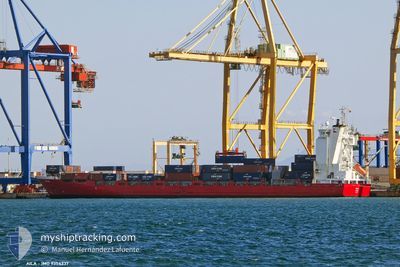
Container Ship
Current Trip
| Trip Time | 2 days |
|---|---|
| Trip Distance | 806.05 nm |
| AVG Speed | 11.5 Knots |
| MAX Speed | 15.8 Knots |
| Draught | 7.1 m |
| AVG Wind | 23 knots |
| MAX Wind | 32.6 knots |
| MIN Temp | 6°C / 42.8°F |
| MAX Temp | 12.3°C / 54.14°F |
| Position Received | 3 m ago |
Current Position
| Longitude | -3.04554° |
|---|---|
| Latitude | 43.34422° |
| Status | Moored |
| Speed | |
| Course | 32° |
| Area | Bay of Biscay |
| Station | T-AIS |
| Position Received | 3 m ago |
Info
Information
The current position of AILA is in Bay of Biscay with coordinates 43.34422° / -3.04554° as reported on 2024-04-19 14:12 by AIS to our vessel tracker app. The vessel's current speed is 0 Knots and is currently inside the port of BILBAO.
The vessel AILA (IMO: 9354337, MMSI: 230985000) is a Container Ship that was built in 2007 ( 17 years old ). It's sailing under the flag of [FI] Finland.
In this page you can find informations about the vessels current position, last detected port calls, and current voyage information. If the vessels is not in coverage by AIS you will find the latest position.
The current position of AILA is detected by our AIS receivers and we are not responsible for the reliability of the data. The last position was recorded while the vessel was in Coverage by the Ais receivers of our vessel tracking app.
The current draught of AILA as reported by AIS is 7.1 meters
Weather
| Temperature | 18.5°C / 65.3°F |
|---|---|
| Wind Speed | 7 knots |
| Direction | 358° N |
| Pressure | 1018.9 hPa |
| Humidity | 35.3 % |
| Cloud Coverage | --- |
Featured Company
Last Port Calls
| Port | Arrival | Departure | Time In Port |
|---|---|---|---|
| 2024-04-18 04:08 | |||
| 2024-04-14 16:36 | 2024-04-15 11:48 | 19 h | |
| 2024-04-13 13:59 | 2024-04-14 02:44 | 12 h | |
| 2024-04-10 10:06 | 2024-04-11 12:29 | 1 d | |
| 2024-04-05 19:41 | 2024-04-06 11:22 | 15 h | |
| 2024-04-03 16:48 | 2024-04-04 10:04 | 17 h | |
| 2024-04-03 06:52 | 2024-04-03 14:52 | 7 h | |
| 2024-04-02 14:36 | 2024-04-02 23:24 | 8 h | |
| 2024-04-01 17:00 | 2024-04-01 23:16 | 6 h | |
| 2024-03-27 15:59 | 2024-03-30 21:27 | 3 d |
Last Trips
| Origin | Departure | Destination | Arrival | Distance | |
|---|---|---|---|---|---|
| 2024-04-15 13:48 | 2024-04-18 06:08 | 806.05 nm | |||
| 2024-04-14 03:44 | 2024-04-14 18:36 | 165.92 nm | |||
| 2024-04-11 14:29 | 2024-04-13 14:59 | 735.24 nm | |||
| 2024-04-06 12:22 | 2024-04-10 12:06 | 848.45 nm | |||
| 2024-04-04 11:04 | 2024-04-05 20:41 | 211.61 nm | |||
| 2024-04-03 00:24 | 2024-04-03 17:48 | 119.76 nm | |||
| 2024-04-03 00:24 | 2024-04-03 07:52 | 100.73 nm | |||
| 2024-04-02 00:16 | 2024-04-02 15:36 | 8.17 nm | |||
| 2024-03-30 22:27 | 2024-04-01 18:00 | 630.18 nm | |||
| 2024-03-25 22:57 | 2024-03-27 16:59 | 629.65 nm |
Events
| Time | Event | Details | Position / Dest | Info |
|---|---|---|---|---|
| 2024-04-18 04:55 | Status Changed | Moored Under way using engine |
43.34421 / -3.04557
[ES] BILBAO
|
Speed: Course: 32° |
| 2024-04-18 04:40 | STOP Moving |
43.34428 / -3.04562
[ES] BILBAO
|
Speed: 0.2 kn Course: 27° |
|
| 2024-04-18 04:08 | PORT ARRIVAL |
|
43.37717 / -3.07930
[ES] BILBAO
|
Speed: 9.2 kn Course: 153° |
| 2024-04-18 03:51 | Change Sea Area | Spanish part of the Bay of Biscay French part of the Celtic Sea |
43.43868 / -3.11440
Bay of Biscay
ESBIO
|
Speed: 15.3 kn Course: 159.8° |
| 2024-04-18 03:51 | Status Changed | Under way using engine Default |
43.43868 / -3.11440
ESBIO
|
Speed: 15.2 kn Course: 162° |
| 2024-04-18 03:51 | IN Coverage |
43.43868 / -3.11440
Bay of Biscay
ESBIO
|
Speed: 15.3 kn Course: 159.8° |
|
| 2024-04-17 01:23 | Status Changed | Default Under way using engine |
49.11283 / -5.10642
ESBIO
|
Speed: 13.5 kn Course: 236.4° |
| 2024-04-17 01:18 | OUT of Coverage |
49.12444 / -5.07968
Celtic Sea
ESBIO
|
Speed: 13.5 kn Course: 236.4° |
|
| 2024-04-17 01:00 | Change Sea Area | French part of the Celtic Sea French part of the English Channel |
49.16614 / -5.00160
Celtic Sea
ESBIO
|
Speed: 13.5 kn Course: 230.7° |
| 2024-04-17 00:52 | Status Changed | Under way using engine Default |
49.18706 / -4.96325
ESBIO
|
Speed: 13.6 kn Course: 232° |