
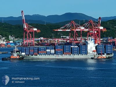
WAN HAI 171
Container Ship
Current Trip
| Time Travelled | 1 day |
|---|---|
| Remaining Time | 21 h, 54 mins |
| Distance Travelled | 476.84 nm |
| Remaining Distance | 475.58 nm |
| AVG Speed | 16.5 Knop |
| MAX Speed | 19.4 Knop |
| AVG Wind | 17.4 knots |
| MAX Wind | 26 knots |
| MIN Temp | 21.7°C / 71.06°F |
| MAX Temp | 24.1°C / 75.38°F |
| Djupgående | 9 m |
| Position mottagen | 1 d sen |
Current Position
| Longitud | 122.09477° |
|---|---|
| Latitude | 25.73567° |
| Status | Under way using engine |
| Fart | 17.1 Knop |
| Kurs | 54.8° |
| Område | Eastern China Sea |
| Station | T-AIS |
| Position mottagen | 1 d sen |
Info
Information
The current position of WAN HAI 171 is in Eastern China Sea with coordinates 25.73567° / 122.09477° as reported on 2024-04-19 02:24 by AIS to our vessel tracker app. The vessel's current speed is 17.1 Knop and is heading at the port of OSAKA. The estimated time of arrival as calculated by MyShipTracking vessel tracking app is 2024-04-21 03:06 LT
The vessel WAN HAI 171 (IMO: 9380257, MMSI: 477217400) is a Container Ship that was built in 2009 ( 15 År gammal ). It's sailing under the flag of [HK] Hong Kong.
In this page you can find informations about the vessels current position, last detected port calls, and current voyage information. If the vessels is not in coverage by AIS you will find the latest position.
The current position of WAN HAI 171 is detected by our AIS receivers and we are not responsible for the reliability of the data. The last position was recorded while the vessel was in Coverage by the Ais receivers of our vessel tracking app.
The current draught of WAN HAI 171 as reported by AIS is 9 meters
Weather
| Temperature | 22.9°C / 73.22°F |
|---|---|
| Wind Speed | 27 knots |
| Direction | 186° S |
| Pressure | 1010.3 hPa |
| Humidity | 76.2 % |
| Cloud Coverage | 97 % |
Featured Company
Last Port Calls
| Port | Arrival | Departure | Time In Port |
|---|---|---|---|
| 2024-04-18 12:30 | 2024-04-18 22:36 | 10 h | |
| 2024-04-17 12:06 | 2024-04-17 23:52 | 11 h | |
| 2024-04-16 04:52 | 2024-04-16 14:31 | 9 h | |
| 2024-04-15 09:04 | 2024-04-15 15:46 | 6 h | |
| 2024-04-11 00:50 | 2024-04-11 14:29 | 13 h | |
| 2024-04-08 23:05 | 2024-04-10 21:43 | 1 d | |
| 2024-04-07 20:59 | 2024-04-08 07:33 | 10 h | |
| 2024-04-03 14:39 | 2024-04-04 01:57 | 11 h | |
| 2024-04-03 03:06 | 2024-04-03 12:33 | 9 h | |
| 2024-04-01 15:23 | 2024-04-02 04:44 | 13 h |
Last Trips
| Origin | Departure | Destination | Arrival | Distance | |
|---|---|---|---|---|---|
| 2024-04-18 07:52 | 2024-04-18 20:30 | 200.71 nm | |||
| 2024-04-16 22:31 | 2024-04-17 20:06 | 354.68 nm | |||
| 2024-04-15 23:46 | 2024-04-16 12:52 | 105.69 nm | |||
| 2024-04-11 21:29 | 2024-04-15 17:04 | 1500.38 nm | |||
| 2024-04-11 04:43 | 2024-04-11 07:50 | 37.22 nm | |||
| 2024-04-08 14:33 | 2024-04-09 06:05 | 39.97 nm | |||
| 2024-04-04 09:57 | 2024-04-08 03:59 | 1513.88 nm | |||
| 2024-04-03 20:33 | 2024-04-03 22:39 | 18.48 nm | |||
| 2024-04-02 12:44 | 2024-04-03 11:06 | 351.53 nm | |||
| 2024-04-01 03:26 | 2024-04-01 23:23 | 216.02 nm |
Events
| Tid | Event | Detaljer | Position / Dest | Information |
|---|---|---|---|---|
| 2024-04-19 02:24 | UTANFÖR täckningsområde |
25.73567 / 122.09477
Eastern China Sea
|
Fart: 17.1 kn Kurs: 54.8° |
|
| 2024-04-19 00:44 | Djupgående ändrat | 9 9.2 |
25.50767 / 121.64051
JPOSA H
|
Fart: 16.4 kn Kurs: 59.9° |
| 2024-04-19 00:44 | Destination ändrad | JPOSA H TWTPE... |
25.50767 / 121.64051
JPOSA H
|
Fart: 16.4 kn Kurs: 59.9° |
| 2024-04-18 23:36 | Upptäckt i hav | Taiwanese part of the Eastern China Sea |
25.34027 / 121.36949
Eastern China Sea
|
Fart: 15.1 kn Kurs: 26.7° |
| 2024-04-18 22:36 | AVGÅTT HAMN |
|
25.20166 / 121.30985
TWTPE...
|
Fart: 6.4 kn Kurs: 254° |
| 2024-04-18 22:22 | Status ändrad | Under way using engine Moored |
25.15886 / 121.38211
[TW] TAIPEI
|
Fart: 3.9 kn Kurs: 238° |
| 2024-04-18 22:18 | I täckningsområde |
25.16295 / 121.38919
South China Sea
[TW] TAIPEI
|
Fart: 3.9 kn Kurs: 235.9° |
|
| 2024-04-18 13:08 | UTANFÖR täckningsområde |
25.16427 / 121.39035
South China Sea
[TW] TAIPEI
|
Fart: Kurs: 112.5° |
|
| 2024-04-18 13:07 | Status ändrad | Moored Under way using engine |
25.16428 / 121.39035
[TW] TAIPEI
|
Fart: Kurs: 245° |
| 2024-04-18 13:03 | STOPPAR förflyttning |
25.16423 / 121.39041
[TW] TAIPEI
|
Fart: 0.2 kn Kurs: 244° |