
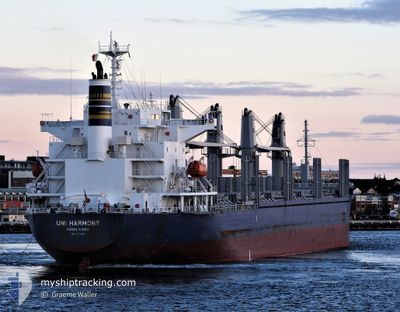
UNI HARMONY
Cargo
Current Trip
FANGCHENG
| Time Travelled | 9 days |
|---|---|
| Remaining Time | --- |
| Distance Travelled | 647.91 nm |
| Remaining Distance | --- |
| AVG Speed | 11.1 Knop |
| MAX Speed | 13.4 Knop |
| AVG Wind | 8.2 knots |
| MAX Wind | 22 knots |
| MIN Temp | 23.4°C / 74.12°F |
| MAX Temp | 29.8°C / 85.64°F |
| Djupgående | 9.7 m |
| Position mottagen | 16 d sen |
Current Position
| Longitud | 101.51350° |
|---|---|
| Latitude | 11.61935° |
| Status | Under way using engine |
| Fart | 12 Knop |
| Kurs | 134.2° |
| Område | Gulf of Thailand |
| Station | T-AIS |
| Position mottagen | 16 d sen |
Info
Information
The current position of UNI HARMONY is in Gulf of Thailand with coordinates 11.61935° / 101.51350° as reported on 2024-04-08 12:17 by AIS to our vessel tracker app. The vessel's current speed is 12 Knop
The vessel UNI HARMONY (IMO: 9775165, MMSI: 477537900) is a Cargo It's sailing under the flag of [HK] Hong Kong.
In this page you can find informations about the vessels current position, last detected port calls, and current voyage information. If the vessels is not in coverage by AIS you will find the latest position.
The current position of UNI HARMONY is detected by our AIS receivers and we are not responsible for the reliability of the data. The last position was recorded while the vessel was in Coverage by the Ais receivers of our vessel tracking app.
The current draught of UNI HARMONY as reported by AIS is 9.7 meters
Weather
| Temperature | 29.5°C / 85.1°F |
|---|---|
| Wind Speed | 7 knots |
| Direction | 127° SE |
| Pressure | 1008.3 hPa |
| Humidity | 76.1 % |
| Cloud Coverage | 71 % |
Featured Company
Last Port Calls
| Port | Arrival | Departure | Time In Port |
|---|---|---|---|
| 2024-04-14 06:10 | 2024-04-15 13:01 | 1 d | |
| 2024-03-22 10:25 | 2024-03-24 01:16 | 1 d | |
| 2024-02-17 09:59 | 2024-02-17 18:10 | 8 h | |
| 2024-02-06 11:07 | 2024-02-08 00:56 | 1 d |
Most Visited Ports (Last year)
| Port | Arrivals | |
|---|---|---|
| 2 | ||
| 1 | ||
| 1 | ||
| 1 | ||
| 1 | ||
| 1 |
Last Trips
| Origin | Departure | Destination | Arrival | Distance | |
|---|---|---|---|---|---|
| 2024-03-24 09:16 | 2024-04-14 14:10 | 2369.91 nm | |||
| 2024-02-17 18:10 | 2024-03-22 18:25 | 9846.50 nm | |||
| 2024-02-08 03:56 | 2024-02-17 09:59 | 2569.79 nm | |||
| 2024-01-25 07:45 | 2024-02-06 14:07 | 1095.55 nm |
Events
| Tid | Event | Detaljer | Position / Dest | Information |
|---|---|---|---|---|
| 2024-04-22 12:52 | STARTAR förflyttning |
20.92190 / 108.25341
FANGCHENG
|
Fart: 6.6 kn Kurs: 184° |
|
| 2024-04-20 18:42 | STOPPAR förflyttning |
20.92810 / 108.25401
FANGCHENG
|
Fart: Kurs: 269° |
|
| 2024-04-20 17:18 | STARTAR förflyttning |
20.94137 / 108.23949
FANGCHENG
|
Fart: 3.8 kn Kurs: 225° |
|
| 2024-04-15 21:11 | STOPPAR förflyttning |
20.96718 / 108.21921
FANGCHENG
|
Fart: 0.3 kn Kurs: 78° |
|
| 2024-04-15 19:58 | STARTAR förflyttning |
20.99771 / 108.24204
FANGCHENG
|
Fart: 3.4 kn Kurs: 224° |
|
| 2024-04-15 17:39 | STOPPAR förflyttning |
21.02593 / 108.23195
FANGCHENG
|
Fart: 0.3 kn Kurs: 236° |
|
| 2024-04-15 13:01 | AVGÅTT HAMN |
|
21.54113 / 108.35487
FANGCHENG
|
Fart: 7.3 kn Kurs: 142° |
| 2024-04-15 12:42 | STARTAR förflyttning |
21.56749 / 108.33331
[CN] FANGCHENG
|
Fart: 4.7 kn Kurs: 157° |