
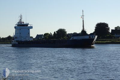
ULRIKE G
General Cargo
Current Trip
ISTAMBUL ROAD
| Time Travelled | 10 h, 52 mins |
|---|---|
| Remaining Time | --- |
| Distance Travelled | 57.21 nm |
| Remaining Distance | --- |
| AVG Speed | 8 Knop |
| MAX Speed | 11.3 Knop |
| AVG Wind | 3 knots |
| MAX Wind | 9.1 knots |
| MIN Temp | 16.8°C / 62.24°F |
| MAX Temp | 21.6°C / 70.88°F |
| Djupgående | 3.8 m |
| Position mottagen | 1 m sen |
Current Position
| Longitud | 28.84576° |
|---|---|
| Latitude | 40.93620° |
| Status | At anchor |
| Fart | 0.1 Knop |
| Kurs | 22° |
| Område | Sea of Marmara |
| Station | T-AIS |
| Position mottagen | 1 m sen |
Info
Information
The current position of ULRIKE G is in Sea of Marmara with coordinates 40.93620° / 28.84576° as reported on 2024-04-24 22:52 by AIS to our vessel tracker app. The vessel's current speed is 0.1 Knop
The vessel ULRIKE G (IMO: 9156113, MMSI: 304407000) is a General Cargo that was built in 2002 ( 22 År gammal ). It's sailing under the flag of [AG] Antigua Barbuda.
In this page you can find informations about the vessels current position, last detected port calls, and current voyage information. If the vessels is not in coverage by AIS you will find the latest position.
The current position of ULRIKE G is detected by our AIS receivers and we are not responsible for the reliability of the data. The last position was recorded while the vessel was in Coverage by the Ais receivers of our vessel tracking app.
The current draught of ULRIKE G as reported by AIS is 3.8 meters
Weather
| Temperature | 17.4°C / 63.32°F |
|---|---|
| Wind Speed | 1 knots |
| Direction | 271° W |
| Pressure | 1005.2 hPa |
| Humidity | 82 % |
| Cloud Coverage | 78 % |
Featured Company
Last Port Calls
| Port | Arrival | Departure | Time In Port |
|---|---|---|---|
| 2024-04-24 01:58 | 2024-04-24 12:01 | 10 h | |
| 2024-04-21 01:59 | 2024-04-22 22:13 | 1 d | |
| 2024-04-16 19:28 | 2024-04-17 02:17 | 6 h | |
| 2024-04-12 05:20 | 2024-04-12 09:58 | 4 h | |
| 2024-03-27 23:00 | 2024-03-27 23:34 | 33 m | |
| 2024-03-26 06:29 | 2024-03-26 14:28 | 7 h | |
| 2024-03-24 21:10 | 2024-03-24 21:14 | 4 m | |
| 2024-03-20 10:07 | 2024-03-22 20:59 | 2 d | |
| 2024-03-02 18:03 | 2024-03-05 07:19 | 2 d | |
| 2024-02-28 20:38 | 2024-03-02 16:26 | 2 d |
Last Trips
| Origin | Departure | Destination | Arrival | Distance | |
|---|---|---|---|---|---|
| 2024-04-23 01:13 | 2024-04-24 04:58 | 57.32 nm | |||
| 2024-04-17 05:17 | 2024-04-21 04:59 | 881.62 nm | |||
| 2024-04-12 11:58 | 2024-04-16 22:28 | 1079.46 nm | |||
| 2024-03-28 00:34 | 2024-04-12 07:20 | 3092.47 nm | |||
| 2024-03-26 15:28 | 2024-03-28 00:00 | 354.51 nm | |||
| 2024-03-24 22:14 | 2024-03-26 07:29 | 351.27 nm | |||
| 2024-03-22 21:59 | 2024-03-24 22:10 | 389.88 nm | |||
| 2024-03-05 10:19 | 2024-03-20 11:07 | 3254.68 nm | |||
| 2024-03-02 19:26 | 2024-03-02 21:03 | 17.24 nm | |||
| 2024-02-24 13:44 | 2024-02-28 23:38 | 826.84 nm |
Events
| Tid | Event | Detaljer | Position / Dest | Information |
|---|---|---|---|---|
| 2024-04-24 22:25 | Status ändrad | At anchor Default |
40.93629 / 28.84552
ISTAMBUL ROAD
|
Fart: 0.1 kn Kurs: 37° |
| 2024-04-24 22:22 | Status ändrad | Default At anchor |
40.93625 / 28.84551
ISTAMBUL ROAD
|
Fart: 0.1 kn Kurs: 33° |
| 2024-04-24 20:49 | Status ändrad | At anchor Default |
40.93602 / 28.84578
ISTAMBUL ROAD
|
Fart: 0.1 kn Kurs: 4° |
| 2024-04-24 20:46 | Status ändrad | Default At anchor |
40.93602 / 28.84586
ISTAMBUL ROAD
|
Fart: 0.1 kn Kurs: 359° |
| 2024-04-24 19:37 | Status ändrad | At anchor Default |
40.93608 / 28.84586
ISTAMBUL ROAD
|
Fart: Kurs: 14° |
| 2024-04-24 19:34 | Status ändrad | Default At anchor |
40.93607 / 28.84586
ISTAMBUL ROAD
|
Fart: Kurs: 18° |
| 2024-04-24 17:55 | Status ändrad | At anchor Under way using engine |
40.93632 / 28.84654
ISTAMBUL ROAD
|
Fart: 0.3 kn Kurs: 335° |
| 2024-04-24 17:54 | STOPPAR förflyttning | 1.49 nm, South East of YESILKOY |
40.93630 / 28.84664
ISTAMBUL ROAD
|
Fart: 0.3 kn Kurs: 333° |
| 2024-04-24 15:07 | Status ändrad | Under way using engine Default |
40.67642 / 28.54972
ISTAMBUL ROAD
|
Fart: 10.7 kn Kurs: 45° |
| 2024-04-24 15:04 | Status ändrad | Default Under way using engine |
40.66964 / 28.54103
ISTAMBUL ROAD
|
Fart: 10.9 kn Kurs: 61.1° |