
TYSLA
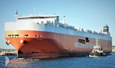
Vehicles Carrier
Current Trip
| Time Travelled | 2 days |
|---|---|
| Remaining Time | 2 days |
| Distance Travelled | 1002.63 nm |
| Remaining Distance | 992.19 nm |
| AVG Speed | 16.9 Knop |
| MAX Speed | 19.2 Knop |
| AVG Wind | 11.7 knots |
| MAX Wind | 23 knots |
| MIN Temp | 23.6°C / 74.48°F |
| MAX Temp | 28.2°C / 82.76°F |
| Djupgående | 11.8 m |
| Position mottagen | 5 h, 23 m sen |
Current Position
| Longitud | -74.46039° |
|---|---|
| Latitude | 22.96769° |
| Status | Under way using engine |
| Fart | 18.5 Knop |
| Kurs | 14.5° |
| Område | North Atlantic Ocean |
| Station | T-AIS |
| Position mottagen | 5 h, 23 m sen |
Info
Information
The current position of TYSLA is in North Atlantic Ocean with coordinates 22.96769° / -74.46039° as reported on 2024-04-19 15:14 by AIS to our vessel tracker app. The vessel's current speed is 18.5 Knop and is heading at the port of MANZANILLO. The estimated time of arrival as calculated by MyShipTracking vessel tracking app is 2024-04-22 06:20 LT
The vessel TYSLA (IMO: 9515400, MMSI: 249909000) is a Vehicles Carrier that was built in 2012 ( 12 År gammal ). It's sailing under the flag of [MT] Malta.
In this page you can find informations about the vessels current position, last detected port calls, and current voyage information. If the vessels is not in coverage by AIS you will find the latest position.
The current position of TYSLA is detected by our AIS receivers and we are not responsible for the reliability of the data. The last position was recorded while the vessel was in Coverage by the Ais receivers of our vessel tracking app.
The current draught of TYSLA as reported by AIS is 11.8 meters
Weather
| Temperature | 23.6°C / 74.48°F |
|---|---|
| Wind Speed | 8 knots |
| Direction | 77° ENE |
| Pressure | 1016.9 hPa |
| Humidity | 67 % |
| Cloud Coverage | 2 % |
Featured Company
Last Port Calls
| Port | Arrival | Departure | Time In Port |
|---|---|---|---|
| 2024-04-16 07:25 | 2024-04-17 10:54 | 1 d | |
| 2024-04-16 03:47 | |||
| 2024-04-16 01:56 | |||
| 2024-04-16 01:50 | |||
| 2024-04-15 18:08 | |||
| 2024-04-15 17:11 | |||
| 2024-03-19 20:36 | 2024-03-20 20:20 | 23 h | |
| 2024-03-16 22:30 | 2024-03-17 15:44 | 17 h | |
| 2024-03-15 10:28 | 2024-03-15 23:32 | 13 h | |
| 2024-03-13 21:45 | 2024-03-14 19:09 | 21 h |
Most Visited Ports (Last year)
| Port | Arrivals | |
|---|---|---|
| 7 | ||
| 5 | ||
| 3 | ||
| 3 | ||
| 3 | ||
| 3 |
Last Trips
| Origin | Departure | Destination | Arrival | Distance | |
|---|---|---|---|---|---|
| 2024-03-21 05:20 | 2024-04-16 02:25 | 8380.95 nm | |||
| 2024-03-21 05:20 | 2024-04-15 22:47 | 8380.88 nm | |||
| 2024-03-21 05:20 | 2024-04-15 20:56 | 8380.81 nm | |||
| 2024-03-21 05:20 | 2024-04-15 20:50 | 8380.74 nm | |||
| 2024-03-21 05:20 | 2024-04-15 13:08 | 8380.68 nm | |||
| 2024-03-21 05:20 | 2024-04-15 12:11 | 8380.57 nm | |||
| 2024-03-18 00:44 | 2024-03-20 05:36 | 560.05 nm | |||
| 2024-03-16 08:32 | 2024-03-17 07:30 | 210.52 nm | |||
| 2024-03-15 04:09 | 2024-03-15 19:28 | 249.30 nm | |||
| 2024-02-24 16:19 | 2024-03-14 06:45 | 4515.75 nm |
Events
| Tid | Event | Detaljer | Position / Dest | Information |
|---|---|---|---|---|
| 2024-04-19 15:53 | Status ändrad | Default Under way using engine |
23.16167 / -74.40334
PA MIT
|
Fart: 18.5 kn Kurs: 14.5° |
| 2024-04-19 15:14 | UTANFÖR täckningsområde |
22.96769 / -74.46039
North Atlantic Ocean
|
Fart: 18.5 kn Kurs: 14.5° |
|
| 2024-04-19 14:16 | Byter havsområde | Bahamas part of the North Atlantic Ocean Panamanian part of the Caribbean Sea |
22.66526 / -74.51845
North Atlantic Ocean
|
Fart: 19.1 kn Kurs: 9.8° |
| 2024-04-19 14:16 | Status ändrad | Under way using engine Default |
22.66526 / -74.51845
PA MIT
|
Fart: 18 kn Kurs: 13° |
| 2024-04-19 14:16 | I täckningsområde |
22.66526 / -74.51845
North Atlantic Ocean
|
Fart: 19.1 kn Kurs: 9.8° |
|
| 2024-04-17 13:06 | Status ändrad | Default Under way using engine |
9.85240 / -79.64142
PA MIT
|
Fart: 17.6 kn Kurs: 28.8° |
| 2024-04-17 12:58 | UTANFÖR täckningsområde |
9.81741 / -79.66089
Caribbean Sea
|
Fart: 17.6 kn Kurs: 28.8° |
|
| 2024-04-17 12:04 | Status ändrad | Under way using engine Default |
9.59929 / -79.79853
PA MIT
|
Fart: 17.1 kn Kurs: 40° |
| 2024-04-17 12:01 | Status ändrad | Default Under way using engine |
9.58827 / -79.80769
PA MIT
|
Fart: 18.1 kn Kurs: 39.3° |
| 2024-04-17 11:05 | Status ändrad | Under way using engine Default |
9.37940 / -79.89668
PA MIT
|
Fart: 4.9 kn Kurs: 355° |