
TIM
General Cargo
Current Trip
| Time Travelled | 1 day |
|---|---|
| Remaining Time | --- |
| Distance Travelled | 38.48 nm |
| Remaining Distance | --- |
| AVG Speed | 9.2 Knop |
| MAX Speed | 10.8 Knop |
| AVG Wind | 12.6 knots |
| MAX Wind | 18 knots |
| MIN Temp | 9.6°C / 49.28°F |
| MAX Temp | 13.1°C / 55.58°F |
| Djupgående | 5.4 m |
| Position mottagen | 3 m sen |
Current Position
| Longitud | -4.93522° |
|---|---|
| Latitude | 50.00116° |
| Status | Under way using engine |
| Fart | 10.3 Knop |
| Kurs | 244.8° |
| Område | English Channel |
| Station | T-AIS |
| Position mottagen | 3 m sen |
Info
Information
The current position of TIM is in English Channel with coordinates 50.00116° / -4.93522° as reported on 2024-04-23 18:32 by AIS to our vessel tracker app. The vessel's current speed is 10.3 Knop and is heading at the port of DROGHEDA. The estimated time of arrival as calculated by MyShipTracking vessel tracking app is 2024-04-24 20:00 LT
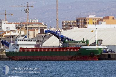
The vessel TIM (IMO: 9434151, MMSI: 212571000) is a General Cargo that was built in 2008 ( 16 År gammal ). It's sailing under the flag of [CY] Cyprus.
In this page you can find informations about the vessels current position, last detected port calls, and current voyage information. If the vessels is not in coverage by AIS you will find the latest position.
The current position of TIM is detected by our AIS receivers and we are not responsible for the reliability of the data. The last position was recorded while the vessel was in Coverage by the Ais receivers of our vessel tracking app.
The current draught of TIM as reported by AIS is 5.4 meters
Weather
| Temperature | 10.6°C / 51.08°F |
|---|---|
| Wind Speed | 15 knots |
| Direction | 338° NNW |
| Pressure | 1023.9 hPa |
| Humidity | 80.7 % |
| Cloud Coverage | 67 % |
Featured Company
Last Port Calls
| Port | Arrival | Departure | Time In Port |
|---|---|---|---|
| 2024-04-22 16:56 | 2024-04-22 17:05 | 8 m | |
| 2024-04-15 00:00 | 2024-04-18 13:13 | 3 d | |
| 2024-04-14 10:22 | 2024-04-14 18:52 | 8 h | |
| 2024-04-12 14:49 | 2024-04-12 18:10 | 3 h | |
| 2024-04-12 05:13 | 2024-04-12 05:52 | 38 m | |
| 2024-04-07 05:36 | 2024-04-10 11:17 | 3 d | |
| 2024-02-28 07:29 | 2024-03-07 11:43 | 8 d | |
| 2024-02-25 11:27 | 2024-02-26 16:07 | 1 d | |
| 2024-02-21 16:29 | 2024-02-23 21:06 | 2 d | |
| 2024-02-14 19:35 | 2024-02-16 22:53 | 2 d |
Last Trips
| Origin | Departure | Destination | Arrival | Distance | |
|---|---|---|---|---|---|
| 2024-04-18 14:13 | 2024-04-22 17:56 | 485.40 nm | |||
| 2024-04-14 19:52 | 2024-04-15 01:00 | 30.28 nm | |||
| 2024-04-12 20:10 | 2024-04-14 11:22 | 372.13 nm | |||
| 2024-04-12 07:52 | 2024-04-12 16:49 | 50.18 nm | |||
| 2024-04-10 14:17 | 2024-04-12 07:13 | 407.46 nm | |||
| 2024-03-07 12:43 | 2024-04-07 08:36 | 2676.27 nm | |||
| 2024-02-26 17:07 | 2024-02-28 08:29 | 358.65 nm | |||
| 2024-02-23 22:06 | 2024-02-25 12:27 | 353.21 nm | |||
| 2024-02-16 22:53 | 2024-02-21 17:29 | 1128.02 nm | |||
| 2024-02-13 00:03 | 2024-02-14 19:35 | 464.60 nm |
Events
| Tid | Event | Detaljer | Position / Dest | Information |
|---|---|---|---|---|
| 2024-04-23 18:24 | Status ändrad | Under way using engine Default |
50.01098 / -4.90288
IEDRO
|
Fart: 10.4 kn Kurs: 246° |
| 2024-04-23 18:22 | Status ändrad | Default Under way using engine |
50.01301 / -4.89581
IEDRO
|
Fart: 10.4 kn Kurs: 245.2° |
| 2024-04-23 14:45 | STARTAR förflyttning | 1.37 nm, East of PLYMOUTH |
50.36097 / -4.11855
IEDRO
|
Fart: 4.4 kn Kurs: 256° |
| 2024-04-23 14:39 | Status ändrad | Under way using engine Moored |
50.36167 / -4.11585
IEDRO
|
Fart: Kurs: 261° |
| 2024-04-23 14:14 | Djupgående ändrat | 5.4 4 |
50.36172 / -4.11590
IEDRO
|
Fart: Kurs: 262° |
| 2024-04-23 14:14 | Destination ändrad | IEDRO GBPLY |
50.36172 / -4.11590
IEDRO
|
Fart: Kurs: 262° |
| 2024-04-23 14:14 | ETA ändrat | 2024/04/24 20:00 2024/04/20 08:00 |
50.36172 / -4.11590
IEDRO
|
Fart: Kurs: 262° |
| 2024-04-22 17:23 | Status ändrad | Moored Under way using engine |
50.36167 / -4.11587
GBPLY
|
Fart: 0.2 kn Kurs: 265° |
| 2024-04-22 17:22 | STOPPAR förflyttning | 1.48 nm, East of PLYMOUTH |
50.36157 / -4.11578
GBPLY
|
Fart: 0.3 kn Kurs: 269° |
| 2024-04-22 17:05 | AVGÅTT HAMN |
|
50.36142 / -4.12351
GBPLY
|
Fart: 1.8 kn Kurs: 123° |