
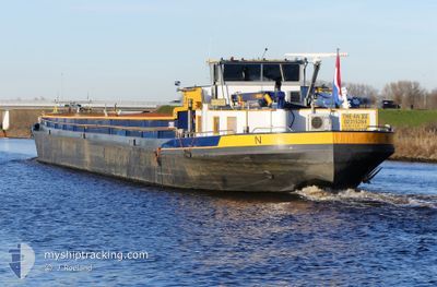
THE-AN 12
Cargo
Current Trip
THE-AN 12 is out of coverage. Learn how you can join the community and extend the coverage to your area by clicking here!
KERKDRIEL
Unknown Port
ETA*
2025-01-29 22:00 UTC
| Time Travelled | 1 day |
|---|---|
| Remaining Time | --- |
| Distance Travelled | 29.01 nm |
| Remaining Distance | --- |
| AVG Speed | 7.6 Knop |
| MAX Speed | 8.8 Knop |
| AVG Wind | 5.8 knots |
| MAX Wind | 7.2 knots |
| MIN Temp | 1.6°C / 34.88°F |
| MAX Temp | 8.1°C / 46.58°F |
| Djupgående | 0 m |
| Position mottagen | 12 h, 44 m sen |
Current Position
| Longitud | 3.36312° |
|---|---|
| Latitude | 50.71552° |
| Status | Constrained by her draught |
| Fart | 6.9 Knop |
| Kurs | 207.9° |
| Område | North Sea |
| Station | T-AIS |
| Position mottagen | 12 h, 44 m sen |
Info
info
Information
The current position of THE-AN 12 is in North Sea with coordinates 50.71552° / 3.36312° as reported on 2024-04-23 09:24 by AIS to our vessel tracker app. The vessel's current speed is 6.9 Knop
The vessel THE-AN 12 (MMSI: 244830615) is a Cargo It's sailing under the flag of [NL] Netherlands.
In this page you can find informations about the vessels current position, last detected port calls, and current voyage information. If the vessels is not in coverage by AIS you will find the latest position.
The current position of THE-AN 12 is detected by our AIS receivers and we are not responsible for the reliability of the data. The last position was recorded while the vessel was in Coverage by the Ais receivers of our vessel tracking app.
Weather
| Temperature | 7.8°C / 46.04°F |
|---|---|
| Wind Speed | 6 knots |
| Direction | 22° NNE |
| Pressure | 1022.4 hPa |
| Humidity | 49.1 % |
| Cloud Coverage | 25 % |
Featured Company
Limited time offer - Install a base station receiver to your area and list your company on MyShipTracking Free forever!
Last Port Calls
| Port | Arrival | Departure | Time In Port |
|---|---|---|---|
| 2024-04-22 19:55 | 2024-04-22 22:00 | 2 h | |
| 2024-04-22 14:43 | 2024-04-22 14:56 | 12 m | |
| 2024-04-22 10:31 | 2024-04-22 11:26 | 54 m | |
| 2024-04-22 01:33 | |||
| 2024-04-19 16:47 | 2024-04-20 19:26 | 1 d | |
| 2024-04-19 15:36 | 2024-04-19 16:07 | 31 m | |
| 2024-04-18 23:31 | 2024-04-18 23:54 | 23 m | |
| 2024-04-18 08:38 | 2024-04-18 10:59 | 2 h | |
| 2024-04-17 16:48 | 2024-04-18 07:11 | 14 h | |
| 2024-04-16 05:56 | 2024-04-16 08:36 | 2 h |
Last Trips
| Origin | Departure | Destination | Arrival | Distance | |
|---|---|---|---|---|---|
| 2024-04-22 16:56 | 2024-04-22 21:55 | 19.63 nm | |||
| 2024-04-22 13:26 | 2024-04-22 16:43 | 24.18 nm | |||
| 2024-04-22 03:33 | 2024-04-22 12:31 | 39.04 nm | |||
| 2024-04-19 18:07 | 2024-04-19 18:47 | 2.40 nm | |||
| 2024-04-19 01:54 | 2024-04-19 17:36 | 2.45 nm | |||
| 2024-04-18 12:59 | 2024-04-19 01:31 | 75.64 nm | |||
| 2024-04-18 09:11 | 2024-04-18 10:38 | 9.05 nm | |||
| 2024-04-16 10:36 | 2024-04-17 18:48 | 41.20 nm | |||
| 2024-04-16 07:21 | 2024-04-16 07:56 | 5.67 nm | |||
| 2024-04-15 17:25 | 2024-04-15 22:50 | 13.98 nm |
Events
| Tid | Event | Detaljer | Position / Dest | Information |
|---|---|---|---|---|
| 2024-04-23 09:24 | UTANFÖR täckningsområde |
50.71552 / 3.36312
North Sea
|
Fart: 6.9 kn Kurs: 207.9° |
|
| 2024-04-23 09:24 | I täckningsområde |
50.71552 / 3.36312
North Sea
|
Fart: 6.9 kn Kurs: 207.9° |
|
| 2024-04-23 07:46 | UTANFÖR täckningsområde |
50.77432 / 3.47255
North Sea
|
Fart: 7.4 kn Kurs: 219.7° |
|
| 2024-04-23 07:41 | STARTAR förflyttning | 1.88 nm, North East of AVELGEM |
50.78085 / 3.48462
KERKDRIEL
|
Fart: 7 kn Kurs: 206.8° |
| 2024-04-23 07:34 | STOPPAR förflyttning | 2.53 nm, North East of AVELGEM |
50.78985 / 3.49449
KERKDRIEL
|
Fart: Kurs: 511° |
| 2024-04-23 06:39 | STARTAR förflyttning | 7.28 nm, North East of AVELGEM |
50.83636 / 3.59645
KERKDRIEL
|
Fart: 7.8 kn Kurs: 243.6° |
| 2024-04-23 06:03 | I täckningsområde |
50.84906 / 3.61680
North Sea
|
Fart: 0.2 kn Kurs: 296.6° |
|
| 2024-04-23 00:04 | UTANFÖR täckningsområde |
50.88113 / 3.63442
North Sea
|
Fart: 7.7 kn Kurs: 235° |
|
| 2024-04-22 23:43 | STARTAR förflyttning | 7.79 nm, South East of DEINZE |
50.90845 / 3.68503
KERKDRIEL
|
Fart: 8.5 kn Kurs: 153.4° |
| 2024-04-22 23:27 | STOPPAR förflyttning | 6.92 nm, South East of DEINZE |
50.91709 / 3.66631
KERKDRIEL
|
Fart: Kurs: 511° |