
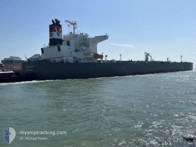
SEAGALAXY
Tanker
Current Trip
| Time Travelled | 1 day |
|---|---|
| Remaining Time | --- |
| Distance Travelled | 433.22 nm |
| Remaining Distance | --- |
| AVG Speed | 12.7 Knop |
| MAX Speed | 14.4 Knop |
| AVG Wind | 12 knots |
| MAX Wind | 17 knots |
| MIN Temp | 29.3°C / 84.74°F |
| MAX Temp | 30.2°C / 86.36°F |
| Djupgående | 8.2 m |
| Position mottagen | 1 d sen |
Current Position
| Longitud | 101.55561° |
|---|---|
| Latitude | 11.69571° |
| Status | Under way using engine |
| Fart | 13 Knop |
| Kurs | 138.5° |
| Område | Gulf of Thailand |
| Station | T-AIS |
| Position mottagen | 1 d sen |
Info
Information
The current position of SEAGALAXY is in Gulf of Thailand with coordinates 11.69571° / 101.55561° as reported on 2024-04-23 16:20 by AIS to our vessel tracker app. The vessel's current speed is 13 Knop and is heading at the port of VUNG TAU. The estimated time of arrival as calculated by MyShipTracking vessel tracking app is 2024-04-25 14:00 LT
The vessel SEAGALAXY (IMO: 9847231, MMSI: 477269100) is a Tanker It's sailing under the flag of [HK] Hong Kong.
In this page you can find informations about the vessels current position, last detected port calls, and current voyage information. If the vessels is not in coverage by AIS you will find the latest position.
The current position of SEAGALAXY is detected by our AIS receivers and we are not responsible for the reliability of the data. The last position was recorded while the vessel was in Coverage by the Ais receivers of our vessel tracking app.
The current draught of SEAGALAXY as reported by AIS is 8.2 meters
Weather
| Temperature | 29.6°C / 85.28°F |
|---|---|
| Wind Speed | 8 knots |
| Direction | 99° E |
| Pressure | 1007.5 hPa |
| Humidity | 71 % |
| Cloud Coverage | 98 % |
Featured Company
Last Port Calls
| Port | Arrival | Departure | Time In Port |
|---|---|---|---|
| 2024-04-22 10:56 | 2024-04-23 10:44 | 23 h | |
| 2024-04-02 00:45 | 2024-04-03 10:03 | 1 d | |
| 2024-03-24 08:29 | 2024-03-25 07:41 | 23 h | |
| 2024-03-13 08:26 | 2024-03-15 02:16 | 1 d |
Most Visited Ports (Last year)
| Port | Arrivals | |
|---|---|---|
| 1 | ||
| 1 | ||
| 1 | ||
| 1 | ||
| 1 | ||
| 1 |
Last Trips
| Origin | Departure | Destination | Arrival | Distance | |
|---|---|---|---|---|---|
| 2024-04-03 18:03 | 2024-04-22 17:56 | 2541.60 nm | |||
| 2024-03-25 15:41 | 2024-04-02 08:45 | 605.70 nm | |||
| 2024-03-15 10:16 | 2024-03-24 16:29 | 101.12 nm | |||
| 2024-01-10 01:04 | 2024-03-13 16:26 | 4066.02 nm |
Events
| Tid | Event | Detaljer | Position / Dest | Information |
|---|---|---|---|---|
| 2024-04-23 16:27 | Status ändrad | Default Under way using engine |
11.67513 / 101.57439
VN VUT
|
Fart: 13 kn Kurs: 138.5° |
| 2024-04-23 16:20 | Status ändrad | Under way using engine Default |
11.69571 / 101.55561
VN VUT
|
Fart: 12.9 kn Kurs: 151° |
| 2024-04-23 16:20 | UTANFÖR täckningsområde |
11.69571 / 101.55561
Gulf of Thailand
VN VUT
|
Fart: 13 kn Kurs: 138.5° |
|
| 2024-04-23 16:00 | I täckningsområde |
11.69571 / 101.55561
Gulf of Thailand
VN VUT
|
Fart: 13 kn Kurs: 138.5° |
|
| 2024-04-23 14:02 | Status ändrad | Default Under way using engine |
12.11790 / 101.29253
VN VUT
|
Fart: 13.3 kn Kurs: 139.3° |
| 2024-04-23 13:58 | UTANFÖR täckningsområde |
12.12826 / 101.28358
Gulf of Thailand
VN VUT
|
Fart: 13.3 kn Kurs: 139.3° |
|
| 2024-04-23 12:59 | Djupgående ändrat | 8.2 8.8 |
12.25997 / 101.11265
VN VUT
|
Fart: 12.8 kn Kurs: 125.8° |
| 2024-04-23 12:59 | Destination ändrad | VN VUT THMTP |
12.25997 / 101.11265
VN VUT
|
Fart: 12.8 kn Kurs: 125.8° |
| 2024-04-23 12:59 | ETA ändrat | 2024/04/25 14:00 2024/04/19 06:00 |
12.25997 / 101.11265
VN VUT
|
Fart: 12.8 kn Kurs: 125.8° |
| 2024-04-23 12:58 | Byter havsområde | Thailand part of the Gulf of Thailand Malaysian part of the South China Sea |
12.26190 / 101.10989
Gulf of Thailand
|
Fart: 12.6 kn Kurs: 127.4° |