
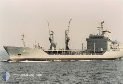
NATO WARSHIP A1443
Military ops
Current Trip
UNDEFINED .
| Time Travelled | 23 days |
|---|---|
| Remaining Time | --- |
| Distance Travelled | 2159.58 nm |
| Remaining Distance | --- |
| AVG Speed | 10.6 Knop |
| MAX Speed | 16.2 Knop |
| AVG Wind | 13.3 knots |
| MAX Wind | 32 knots |
| MIN Temp | 1°C / 33.8°F |
| MAX Temp | 9.4°C / 48.92°F |
| Djupgående | 7.3 m |
| Position mottagen | 1 m sen |
Current Position
| Longitud | 5.26509° |
|---|---|
| Latitude | 59.05414° |
| Status | Under way using engine |
| Fart | 5.6 Knop |
| Kurs | 61.7° |
| Område | North Sea |
| Station | T-AIS |
| Position mottagen | 1 m sen |
Info
Information
The current position of NATO WARSHIP A1443 is in North Sea with coordinates 59.05414° / 5.26509° as reported on 2024-04-25 06:26 by AIS to our vessel tracker app. The vessel's current speed is 5.6 Knop
The vessel NATO WARSHIP A1443 (MMSI: 211211840) is a Military ops It's sailing under the flag of [DE] Germany.
In this page you can find informations about the vessels current position, last detected port calls, and current voyage information. If the vessels is not in coverage by AIS you will find the latest position.
The current position of NATO WARSHIP A1443 is detected by our AIS receivers and we are not responsible for the reliability of the data. The last position was recorded while the vessel was in Coverage by the Ais receivers of our vessel tracking app.
The current draught of NATO WARSHIP A1443 as reported by AIS is 7.3 meters
Weather
| Temperature | 4.6°C / 40.28°F |
|---|---|
| Wind Speed | 8 knots |
| Direction | 137° SE |
| Pressure | 1004.3 hPa |
| Humidity | 72 % |
| Cloud Coverage | 66 % |
Featured Company
Last Port Calls
| Port | Arrival | Departure | Time In Port |
|---|---|---|---|
| 2024-04-12 06:05 | |||
| 2024-04-01 14:26 |
Most Visited Ports (Last year)
| Port | Arrivals | |
|---|---|---|
| 3 | ||
| 1 | ||
| 1 |
Last Trips
| Origin | Departure | Destination | Arrival | Distance | |
|---|---|---|---|---|---|
| 2024-04-01 16:26 | 2024-04-12 09:05 | 1176.56 nm |
Events
| Tid | Event | Detaljer | Position / Dest | Information |
|---|---|---|---|---|
| 2024-04-25 04:38 | Byter havsområde | Norwegian part of the North Sea German part of the Baltic Sea |
58.87611 / 5.04899
North Sea
|
Fart: 5.8 kn Kurs: 85.5° |
| 2024-04-25 04:35 | I täckningsområde |
58.87611 / 5.04899
North Sea
|
Fart: 5.8 kn Kurs: 85.5° |
|
| 2024-04-22 17:36 | UTANFÖR täckningsområde |
54.59817 / 10.40305
Baltic Sea
|
Fart: 9.9 kn Kurs: 75.6° |
|
| 2024-04-22 13:57 | STARTAR förflyttning | 4.97 nm, South East of OLPENITZ |
54.62096 / 10.16141
UNDEFINED .
|
Fart: 6.6 kn Kurs: 147.3° |
| 2024-04-22 13:56 | STOPPAR förflyttning | 4.87 nm, South East of OLPENITZ |
54.62264 / 10.15955
UNDEFINED .
|
Fart: Kurs: 0° |
| 2024-04-22 13:56 | STARTAR förflyttning | 4.86 nm, South East of OLPENITZ |
54.62275 / 10.15944
UNDEFINED .
|
Fart: 6.6 kn Kurs: 147.2° |
| 2024-04-22 13:55 | STOPPAR förflyttning | 4.76 nm, South East of OLPENITZ |
54.62426 / 10.15774
UNDEFINED .
|
Fart: Kurs: 0° |
| 2024-04-22 08:39 | STARTAR förflyttning | 3.4 nm, East of DAMP |
54.56161 / 10.11834
UNDEFINED .
|
Fart: 3.1 kn Kurs: 21° |
| 2024-04-22 06:52 | STOPPAR förflyttning | 3.87 nm, South East of DAMP |
54.54050 / 10.11234
UNDEFINED .
|
Fart: 0.3 kn Kurs: 21° |
| 2024-04-22 05:23 | STARTAR förflyttning | 4.98 nm, South East of DAMP |
54.50749 / 10.08998
UNDEFINED .
|
Fart: 3.1 kn Kurs: 20° |