
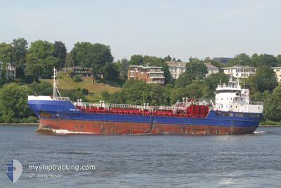
NOR STAR
Chemical Tanker
Current Trip
| Time Travelled | 1 day |
|---|---|
| Remaining Time | 4 h, 37 mins |
| Distance Travelled | 350.90 nm |
| Remaining Distance | 52.31 nm |
| AVG Speed | 9.6 Knop |
| MAX Speed | 11.4 Knop |
| AVG Wind | 16.1 knots |
| MAX Wind | 22 knots |
| MIN Temp | 0.7°C / 33.26°F |
| MAX Temp | 5.6°C / 42.08°F |
| Djupgående | 4.3 m |
| Position mottagen | 1 m sen |
Current Position
| Longitud | 8.55836° |
|---|---|
| Latitude | 63.40126° |
| Status | Under way using engine |
| Fart | 11 Knop |
| Kurs | 67.2° |
| Område | Norwegian Sea |
| Station | T-AIS |
| Position mottagen | 1 m sen |
Info
Information
The current position of NOR STAR is in Norwegian Sea with coordinates 63.40126° / 8.55836° as reported on 2024-04-19 01:19 by AIS to our vessel tracker app. The vessel's current speed is 11 Knop and is heading at the port of LYSOYSUND. The estimated time of arrival as calculated by MyShipTracking vessel tracking app is 2024-04-19 05:58 LT
The vessel NOR STAR (IMO: 8719102, MMSI: 630001042) is a Chemical Tanker that was built in 1992 ( 32 År gammal ). It's sailing under the flag of [GW] Guinea-Bissau.
In this page you can find informations about the vessels current position, last detected port calls, and current voyage information. If the vessels is not in coverage by AIS you will find the latest position.
The current position of NOR STAR is detected by our AIS receivers and we are not responsible for the reliability of the data. The last position was recorded while the vessel was in Coverage by the Ais receivers of our vessel tracking app.
The current draught of NOR STAR as reported by AIS is 4.3 meters
Weather
| Temperature | 3°C / 37.4°F |
|---|---|
| Wind Speed | 4 knots |
| Direction | 112° ESE |
| Pressure | 1005.3 hPa |
| Humidity | 63.3 % |
| Cloud Coverage | 100 % |
Featured Company
Last Port Calls
| Port | Arrival | Departure | Time In Port |
|---|---|---|---|
| 2024-04-09 15:18 | 2024-04-17 12:22 | 7 d | |
| 2024-04-06 18:02 | 2024-04-07 11:06 | 17 h | |
| 2024-03-29 13:41 | 2024-03-30 11:17 | 21 h | |
| 2024-03-24 19:14 | 2024-03-24 20:36 | 1 h | |
| 2024-03-21 00:15 | 2024-03-21 18:07 | 17 h | |
| 2024-03-17 21:55 | 2024-03-18 11:45 | 13 h | |
| 2024-03-16 05:28 | 2024-03-16 19:23 | 13 h | |
| 2024-03-13 21:24 | 2024-03-14 19:47 | 22 h | |
| 2024-03-08 05:40 | 2024-03-09 11:05 | 1 d | |
| 2024-03-06 11:56 | 2024-03-06 19:07 | 7 h |
Last Trips
| Origin | Departure | Destination | Arrival | Distance | |
|---|---|---|---|---|---|
| 2024-04-07 13:06 | 2024-04-09 17:18 | 540.09 nm | |||
| 2024-03-30 12:17 | 2024-04-06 20:02 | 1533.97 nm | |||
| 2024-03-24 21:36 | 2024-03-29 14:41 | 1038.23 nm | |||
| 2024-03-21 19:07 | 2024-03-24 20:14 | 596.63 nm | |||
| 2024-03-18 12:45 | 2024-03-21 01:15 | 578.36 nm | |||
| 2024-03-16 20:23 | 2024-03-17 22:55 | 246.29 nm | |||
| 2024-03-14 20:47 | 2024-03-16 06:28 | 290.08 nm | |||
| 2024-03-09 12:05 | 2024-03-13 22:24 | 920.51 nm | |||
| 2024-03-06 20:07 | 2024-03-08 06:40 | 388.77 nm | |||
| 2024-03-05 16:55 | 2024-03-06 12:56 | 246.32 nm |
Events
| Tid | Event | Detaljer | Position / Dest | Information |
|---|---|---|---|---|
| 2024-04-18 10:32 | Status ändrad | Under way using engine Moored |
62.20705 / 4.59387
LYSOYSUND
|
Fart: 10.8 kn Kurs: 14.9° |
| 2024-04-18 03:39 | Byter havsområde | Norwegian part of the Norwegian Sea Norwegian part of the North Sea |
61.00521 / 4.27022
Norwegian Sea
LYSOYSUND
|
Fart: 9.2 kn Kurs: 359.1° |
| 2024-04-17 16:19 | Destination ändrad | LYSOYSUND NO LSU |
59.33314 / 4.58458
LYSOYSUND
|
Fart: 9.9 kn Kurs: 337.3° |
| 2024-04-17 16:19 | ETA ändrat | 2024/04/19 03:03 2024/04/18 23:00 |
59.33314 / 4.58458
LYSOYSUND
|
Fart: 9.9 kn Kurs: 337.3° |
| 2024-04-17 16:15 | Status ändrad | Moored Under way using engine |
59.32532 / 4.59397
NO LSU
|
Fart: 9.7 kn Kurs: 324.2° |
| 2024-04-17 12:50 | ETA ändrat | 2024/04/18 23:00 2024/04/18 17:00 |
59.22974 / 5.33915
NO LSU
|
Fart: 9.3 kn Kurs: 177.7° |
| 2024-04-17 12:39 | ETA ändrat | 2024/04/18 17:00 2024/04/09 17:00 |
59.25017 / 5.33770
NO LSU
|
Fart: 6.2 kn Kurs: 176.4° |
| 2024-04-17 12:37 | Destination ändrad | NO LSU NOKOP |
59.25543 / 5.33694
NO LSU
|
Fart: 6.6 kn Kurs: 174.9° |
| 2024-04-17 12:27 | Status ändrad | Under way using engine Moored |
59.27807 / 5.33320
NOKOP
|
Fart: 9.2 kn Kurs: 160.3° |
| 2024-04-17 12:22 | AVGÅTT HAMN |
|
59.28575 / 5.31987
NOKOP
|
Fart: 4.8 kn Kurs: 84° |