
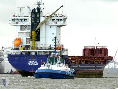
NETA A.
Container Ship
Current Trip
| Time Travelled | 1 day |
|---|---|
| Remaining Time | 26 mins |
| Distance Travelled | 397.18 nm |
| Remaining Distance | 9.22 nm |
| AVG Speed | 13.5 Knop |
| MAX Speed | 15.3 Knop |
| AVG Wind | 14.7 knots |
| MAX Wind | 24 knots |
| MIN Temp | 6°C / 42.8°F |
| MAX Temp | 10°C / 50°F |
| Djupgående | 8.2 m |
| Position mottagen | Nu |
Current Position
| Longitud | --- |
|---|---|
| Latitude | --- |
| Status | Under way using engine |
| Fart | 12 Knop |
| Kurs | 209.6° |
| Område | Baltic Sea |
| Station | T-AIS |
| Position mottagen | Nu |
Info
Information
The current position of NETA A. is in Baltic Sea with coordinates 54.46655° / 10.25054° as reported on 2025-12-09 13:43 by AIS to our vessel tracker app. The vessel's current speed is 12 Knop and is heading at the port of KIEL. The estimated time of arrival as calculated by MyShipTracking vessel tracking app is 2025-12-09 15:10 LT
The vessel NETA A. (IMO: 9412531, MMSI: 636025672) is a Container Ship that was built in 2011 ( 14 År gammal ). It's sailing under the flag of [LR] Liberia.
In this page you can find informations about the vessels current position, last detected port calls, and current voyage information. If the vessels is not in coverage by AIS you will find the latest position.
The current position of NETA A. is detected by our AIS receivers and we are not responsible for the reliability of the data. The last position was recorded while the vessel was in Coverage by the Ais receivers of our vessel tracking app.
The current draught of NETA A. as reported by AIS is 8.2 meters
Weather
| Temperature | 10°C / 50°F |
|---|---|
| Wind Speed | 11 knots |
| Direction | 205° SSW |
| Pressure | 1010.2 hPa |
| Humidity | 98.6 % |
| Cloud Coverage | 100 % |
Featured Company
Last Port Calls
| Port | Arrival | Departure | Time In Port |
|---|---|---|---|
| 2025-12-08 01:48 | 2025-12-08 10:51 | 9 h | |
| 2025-12-05 18:53 | 2025-12-07 10:03 | 1 d | |
| 2025-12-05 10:20 | 2025-12-05 16:15 | 5 h | |
| 2025-12-04 08:04 | 2025-12-04 08:07 | 3 m | |
| 2025-12-01 14:42 | 2025-12-03 02:04 | 1 d | |
| 2025-11-29 07:07 | 2025-12-01 14:35 | 2 d | |
| 2025-11-28 16:50 | 2025-11-29 05:55 | 13 h | |
| 2025-11-26 18:06 | 2025-11-27 15:12 | 21 h | |
| 2025-11-24 20:13 | 2025-11-25 12:19 | 16 h | |
| 2025-11-19 06:54 | 2025-11-20 21:17 | 1 d |
Most Visited Ports (Last year)
| Port | Arrivals | |
|---|---|---|
| 4 | ||
| 2 | ||
| 2 | ||
| 2 | ||
| 2 | ||
| 2 |
Last Trips
| Origin | Departure | Destination | Arrival | Distance | |
|---|---|---|---|---|---|
| 2025-12-07 10:03 | 2025-12-08 01:48 | 126.49 nm | |||
| 2025-12-05 16:15 | 2025-12-05 18:53 | 20.03 nm | |||
| 2025-12-04 08:07 | 2025-12-05 10:20 | 354.24 nm | |||
| 2025-12-03 02:04 | 2025-12-04 08:04 | 315.27 nm | |||
| 2025-12-01 14:35 | 2025-12-01 14:42 | 0.45 nm | |||
| 2025-11-29 05:55 | 2025-11-29 07:07 | 15.39 nm | |||
| 2025-11-27 15:12 | 2025-11-28 16:50 | 323.42 nm | |||
| 2025-11-25 12:19 | 2025-11-26 18:06 | 108.21 nm | |||
| 2025-11-20 21:17 | 2025-11-24 20:13 | 905.24 nm | |||
| 2025-11-15 15:45 | 2025-11-19 06:54 | 1058.20 nm |
Events
| Tid | Event | Detaljer | Position / Dest | Information |
|---|---|---|---|---|
| 2025-12-09 13:01 | Byter havsområde | German part of the Baltic Sea Danish part of the Baltic Sea |
54.53894 / 10.45431
Baltic Sea
DENOK
|
Fart: 14.5 kn Kurs: 246.6° |
| 2025-12-09 12:08 | Byter havsområde | Danish part of the Baltic Sea German part of the Baltic Sea |
54.58748 / 10.80135
Baltic Sea
DENOK
|
Fart: 14 kn Kurs: 264° |
| 2025-12-09 10:47 | Byter havsområde | German part of the Baltic Sea Danish part of the Baltic Sea |
54.55624 / 11.34217
Baltic Sea
DENOK
|
Fart: 15.1 kn Kurs: 302.4° |
| 2025-12-09 08:46 | Byter havsområde | Danish part of the Baltic Sea German part of the Baltic Sea |
54.44406 / 12.13360
Baltic Sea
DENOK
|
Fart: 14.1 kn Kurs: 268.9° |
| 2025-12-09 08:27 | Upptäckt i hav | German part of the Baltic Sea |
54.48719 / 12.20795
Baltic Sea
DENOK
|
Fart: 14.1 kn Kurs: 193.3° |
| 2025-12-09 08:03 | Upptäckt i hav | Danish part of the Baltic Sea |
54.57919 / 12.25314
Baltic Sea
DENOK
|
Fart: 14.3 kn Kurs: 197.1° |
| 2025-12-09 08:03 | I täckningsområde |
54.57919 / 12.25314
Baltic Sea
DENOK
|
Fart: 14.3 kn Kurs: 197.1° |
|
| 2025-12-09 01:10 | UTANFÖR täckningsområde |
55.43286 / 14.60908
Baltic Sea
DENOK
|
Fart: 14 kn Kurs: 248.2° |
|
| 2025-12-09 01:01 | Byter havsområde | Swedish part of the Baltic Sea Danish part of the Kattegat |
55.44470 / 14.66219
Baltic Sea
DENOK
|
Fart: 14.1 kn Kurs: 249.6° |
| 2025-12-08 23:07 | Upptäckt i hav | Danish part of the Kattegat |
55.53996 / 15.42548
Kattegat
DENOK
|
Fart: 13.6 kn Kurs: 258.7° |