
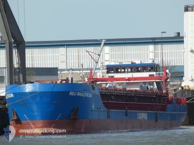
RDJ WAALSTROOM
General Cargo
Current Trip
NLRTM
| Time Travelled | --- |
|---|---|
| Remaining Time | --- |
| Distance Travelled | 115.26 nm |
| Remaining Distance | --- |
| AVG Speed | 7.8 Knop |
| MAX Speed | 11.3 Knop |
| AVG Wind | 8.8 knots |
| MAX Wind | 18 knots |
| MIN Temp | 5.7°C / 42.26°F |
| MAX Temp | 15.1°C / 59.18°F |
| Djupgående | 2.8 m |
| Position mottagen | 2 m sen |
Current Position
| Longitud | 4.57211° |
|---|---|
| Latitude | 51.90181° |
| Status | Moored |
| Fart | |
| Kurs | 84° |
| Område | North Sea |
| Station | T-AIS |
| Position mottagen | 2 m sen |
Info
Information
The current position of RDJ WAALSTROOM is in North Sea with coordinates 51.90181° / 4.57211° as reported on 2024-04-20 06:44 by AIS to our vessel tracker app. The vessel's current speed is 0 Knop
The vessel RDJ WAALSTROOM (IMO: 9248370, MMSI: 305916000) is a General Cargo that was built in 2003 ( 21 År gammal ). It's sailing under the flag of [AG] Antigua Barbuda.
In this page you can find informations about the vessels current position, last detected port calls, and current voyage information. If the vessels is not in coverage by AIS you will find the latest position.
The current position of RDJ WAALSTROOM is detected by our AIS receivers and we are not responsible for the reliability of the data. The last position was recorded while the vessel was in Coverage by the Ais receivers of our vessel tracking app.
The current draught of RDJ WAALSTROOM as reported by AIS is 2.8 meters
Weather
| Temperature | 6.4°C / 43.52°F |
|---|---|
| Wind Speed | 11 knots |
| Direction | 351° N |
| Pressure | 1020.6 hPa |
| Humidity | 74.9 % |
| Cloud Coverage | 96 % |
Featured Company
Last Port Calls
Last Trips
| Origin | Departure | Destination | Arrival | Distance |
|---|
Events
| Tid | Event | Detaljer | Position / Dest | Information |
|---|---|---|---|---|
| 2024-04-19 16:05 | Status ändrad | Moored Default |
51.90176 / 4.57217
NLRTM
|
Fart: Kurs: -1° |
| 2024-04-19 16:04 | Status ändrad | Default Moored |
51.90167 / 4.57167
NLRTM
|
Fart: Kurs: 85° |
| 2024-04-17 13:59 | STOPPAR förflyttning | 0.41 nm, South West of KRIMPEN |
51.90233 / 4.57172
NLRTM
|
Fart: Kurs: 96° |
| 2024-04-17 09:34 | Status ändrad | Moored Default |
51.72115 / 4.39397
NLRTM
|
Fart: 6.9 kn Kurs: 322° |
| 2024-04-17 08:56 | Status ändrad | Default Moored |
51.69623 / 4.52414
NLRTM
|
Fart: 5.7 kn Kurs: 253.8° |
| 2024-04-17 06:41 | STARTAR förflyttning | 0.4 nm, South of KRIMPEN |
51.90195 / 4.57853
NLRTM
|
Fart: 5.3 kn Kurs: 110.8° |
| 2024-04-10 15:25 | STOPPAR förflyttning | 0.36 nm, South of KRIMPEN |
51.90261 / 4.57555
NLRTM
|
Fart: Kurs: 86° |
| 2024-04-10 13:53 | Status ändrad | Moored Default |
51.75545 / 4.62944
NLRTM
|
Fart: 10.9 kn Kurs: 2° |
| 2024-04-10 13:50 | Status ändrad | Default Moored |
51.74457 / 4.63230
NLRTM
|
Fart: 11.1 kn Kurs: 12.6° |
| 2024-04-10 13:41 | Status ändrad | Moored Default |
51.71946 / 4.62186
NLRTM
|
Fart: 8.8 kn Kurs: 49° |