
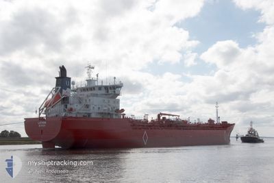
LATANA
Oil/Chemical Tanker
Current Trip
| Time Travelled | 18 h, 25 mins |
|---|---|
| Remaining Time | 1 day |
| Distance Travelled | 235.34 nm |
| Remaining Distance | 311.14 nm |
| AVG Speed | 13 Knop |
| MAX Speed | 15.9 Knop |
| AVG Wind | 13.6 knots |
| MAX Wind | 20 knots |
| MIN Temp | 4.4°C / 39.92°F |
| MAX Temp | 6.1°C / 42.98°F |
| Djupgående | 6.2 m |
| Position mottagen | Nu |
Current Position
| Longitud | 4.93316° |
|---|---|
| Latitude | 58.61616° |
| Status | Under way using engine |
| Fart | 11.1 Knop |
| Kurs | 319.1° |
| Område | North Sea |
| Station | T-AIS |
| Position mottagen | Nu |
Info
Information
The current position of LATANA is in North Sea with coordinates 58.61616° / 4.93316° as reported on 2024-04-24 13:42 by AIS to our vessel tracker app. The vessel's current speed is 11.1 Knop and is heading at the port of ELNESVAGEN. The estimated time of arrival as calculated by MyShipTracking vessel tracking app is 2024-04-25 16:41 LT
The vessel LATANA (IMO: 9186352, MMSI: 257374000) is a Oil/Chemical Tanker that was built in 2000 ( 24 År gammal ). It's sailing under the flag of [NO] Norway.
In this page you can find informations about the vessels current position, last detected port calls, and current voyage information. If the vessels is not in coverage by AIS you will find the latest position.
The current position of LATANA is detected by our AIS receivers and we are not responsible for the reliability of the data. The last position was recorded while the vessel was in Coverage by the Ais receivers of our vessel tracking app.
The current draught of LATANA as reported by AIS is 6.2 meters
Weather
| Temperature | 5.2°C / 41.36°F |
|---|---|
| Wind Speed | 19 knots |
| Direction | 348° NNW |
| Pressure | 1009.9 hPa |
| Humidity | 68.8 % |
| Cloud Coverage | 7 % |
Featured Company
Last Port Calls
| Port | Arrival | Departure | Time In Port |
|---|---|---|---|
| 2024-04-22 20:29 | 2024-04-23 19:18 | 22 h | |
| 2024-04-14 06:26 | 2024-04-15 02:19 | 19 h | |
| 2024-04-04 05:39 | 2024-04-04 23:23 | 17 h | |
| 2024-04-03 11:27 | 2024-04-03 18:20 | 6 h | |
| 2024-03-31 12:03 | 2024-04-01 15:39 | 1 d | |
| 2024-03-19 08:02 | 2024-03-22 16:17 | 3 d | |
| 2024-03-09 05:09 | 2024-03-09 20:55 | 15 h | |
| 2024-02-27 10:01 | 2024-02-28 20:09 | 1 d | |
| 2024-02-17 17:40 | 2024-02-18 08:49 | 15 h | |
| 2024-02-06 01:08 | 2024-02-07 04:57 | 1 d |
Most Visited Ports (Last year)
| Port | Arrivals | |
|---|---|---|
| 46 | ||
| 7 | ||
| 7 | ||
| 6 | ||
| 1 | ||
| 1 |
Last Trips
| Origin | Departure | Destination | Arrival | Distance | |
|---|---|---|---|---|---|
| 2024-04-15 04:19 | 2024-04-22 22:29 | 2017.84 nm | |||
| 2024-04-05 01:23 | 2024-04-14 08:26 | 2534.60 nm | |||
| 2024-04-03 20:20 | 2024-04-04 07:39 | 0.83 nm | |||
| 2024-04-01 17:39 | 2024-04-03 13:27 | 3.88 nm | |||
| 2024-03-22 17:17 | 2024-03-31 14:03 | 203.86 nm | |||
| 2024-03-09 21:55 | 2024-03-19 09:02 | 2373.37 nm | |||
| 2024-02-28 21:09 | 2024-03-09 06:09 | 2526.42 nm | |||
| 2024-02-18 09:49 | 2024-02-27 11:01 | 2534.07 nm | |||
| 2024-02-07 05:57 | 2024-02-17 18:40 | 2547.63 nm | |||
| 2024-01-26 17:00 | 2024-02-06 02:08 | 2527.40 nm |
Events
| Tid | Event | Detaljer | Position / Dest | Information |
|---|---|---|---|---|
| 2024-04-24 05:37 | Upptäckt i hav | Norwegian part of the North Sea |
57.79155 / 7.37271
North Sea
FIFOR > NOELN
|
Fart: 14.6 kn Kurs: 274.4° |
| 2024-04-24 01:41 | Byter havsområde | Norwegian part of the Skaggerak Danish part of the Skaggerak |
57.81404 / 9.07537
Skaggerak
FIFOR > NOELN
|
Fart: 12.8 kn Kurs: 265.7° |
| 2024-04-23 21:16 | Byter havsområde | Danish part of the Skaggerak Danish part of the Kattegat |
57.77290 / 10.80455
Skaggerak
FIFOR > NOELN
|
Fart: 14 kn Kurs: 356.7° |
| 2024-04-23 19:18 | AVGÅTT HAMN |
|
57.43119 / 10.55611
FIFOR > NOELN
|
Fart: 7.9 kn Kurs: 131° |
| 2024-04-23 19:14 | STARTAR förflyttning |
57.43505 / 10.54718
[DK] FREDERIKSHAVN
|
Fart: 3.1 kn Kurs: 127° |
|
| 2024-04-23 18:57 | ETA ändrat | 2024/04/26 12:00 2024/04/24 12:00 |
57.43796 / 10.54394
[DK] FREDERIKSHAVN
|
Fart: Kurs: 136° |
| 2024-04-23 18:57 | Status ändrad | Under way using engine Moored |
57.43795 / 10.54394
[DK] FREDERIKSHAVN
|
Fart: Kurs: 136° |
| 2024-04-22 20:58 | Status ändrad | Moored Under way using engine |
57.43794 / 10.54410
[DK] FREDERIKSHAVN
|
Fart: Kurs: 140° |
| 2024-04-22 20:51 | STOPPAR förflyttning |
57.43787 / 10.54433
[DK] FREDERIKSHAVN
|
Fart: 0.3 kn Kurs: 130° |
|
| 2024-04-22 20:29 | ANLÄNDER HAMN |
|
57.43243 / 10.55363
[DK] FREDERIKSHAVN
|
Fart: 3.3 kn Kurs: 306° |