
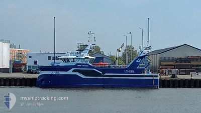
JONGE JOHANNES LT295
Fishing
Current Trip
VLISSINGEN
| Time Travelled | 1 day |
|---|---|
| Remaining Time | --- |
| Distance Travelled | 97.39 nm |
| Remaining Distance | --- |
| AVG Speed | 10.9 Knop |
| MAX Speed | 12.7 Knop |
| AVG Wind | 14.7 knots |
| MAX Wind | 17 knots |
| MIN Temp | 7.8°C / 46.04°F |
| MAX Temp | 8.5°C / 47.3°F |
| Djupgående | 0 m |
| Position mottagen | 16 h, 0 m sen |
Current Position
| Longitud | 1.52300° |
|---|---|
| Latitude | 51.04909° |
| Status | Under way sailing |
| Fart | 10.6 Knop |
| Kurs | 226° |
| Område | English Channel |
| Station | T-AIS |
| Position mottagen | 16 h, 0 m sen |
Info
Information
The current position of JONGE JOHANNES LT295 is in English Channel with coordinates 51.04909° / 1.52300° as reported on 2024-04-22 21:10 by AIS to our vessel tracker app. The vessel's current speed is 10.6 Knop
The vessel JONGE JOHANNES LT295 (IMO: 9848792, MMSI: 232026100) is a Fishing It's sailing under the flag of [GB] United Kingdom.
In this page you can find informations about the vessels current position, last detected port calls, and current voyage information. If the vessels is not in coverage by AIS you will find the latest position.
The current position of JONGE JOHANNES LT295 is detected by our AIS receivers and we are not responsible for the reliability of the data. The last position was recorded while the vessel was in Coverage by the Ais receivers of our vessel tracking app.
Weather
| Temperature | 8.1°C / 46.58°F |
|---|---|
| Wind Speed | 14 knots |
| Direction | 41° NE |
| Pressure | 1024.9 hPa |
| Humidity | 56.9 % |
| Cloud Coverage | 41 % |
Featured Company
Last Port Calls
| Port | Arrival | Departure | Time In Port |
|---|---|---|---|
| 2024-04-18 21:50 | 2024-04-22 00:26 | 3 d | |
| 2024-04-12 14:29 | 2024-04-15 00:31 | 2 d | |
| 2024-04-05 19:44 | 2024-04-08 00:28 | 2 d | |
| 2024-03-28 20:19 | 2024-04-01 15:15 | 3 d | |
| 2024-03-22 14:50 | 2024-03-25 01:31 | 2 d | |
| 2024-03-15 16:22 | 2024-03-18 01:34 | 2 d | |
| 2024-03-11 09:56 | 2024-03-11 13:43 | 3 h | |
| 2024-03-08 16:17 | 2024-03-11 01:33 | 2 d | |
| 2024-03-01 20:46 | 2024-03-04 02:19 | 2 d | |
| 2024-02-23 00:15 | 2024-02-26 01:31 | 3 d |
Most Visited Ports (Last year)
| Port | Arrivals | |
|---|---|---|
| 42 | ||
| 16 | ||
| 2 | ||
| 1 | ||
| 1 | ||
| 1 |
Last Trips
| Origin | Departure | Destination | Arrival | Distance | |
|---|---|---|---|---|---|
| 2024-04-15 02:31 | 2024-04-18 23:50 | 419.77 nm | |||
| 2024-04-08 02:28 | 2024-04-12 16:29 | 465.73 nm | |||
| 2024-04-01 17:15 | 2024-04-05 21:44 | 321.76 nm | |||
| 2024-03-25 02:31 | 2024-03-28 21:19 | 386.64 nm | |||
| 2024-03-18 02:34 | 2024-03-22 15:50 | 549.43 nm | |||
| 2024-03-11 13:43 | 2024-03-15 17:22 | 520.07 nm | |||
| 2024-03-11 02:33 | 2024-03-11 09:56 | 89.16 nm | |||
| 2024-03-04 03:19 | 2024-03-08 17:17 | 593.25 nm | |||
| 2024-02-26 02:31 | 2024-03-01 21:46 | 674.42 nm | |||
| 2024-02-19 01:32 | 2024-02-23 01:15 | 550.83 nm |
Events
| Tid | Event | Detaljer | Position / Dest | Information |
|---|---|---|---|---|
| 2024-04-22 21:10 | UTANFÖR täckningsområde |
51.04909 / 1.52300
English Channel
|
Fart: 10.6 kn Kurs: 226° |
|
| 2024-04-22 21:10 | Upptäckt i hav | United Kingdom part of the English Channel |
51.04909 / 1.52300
English Channel
|
Fart: 10.6 kn Kurs: 226° |
| 2024-04-22 18:57 | Upptäckt i hav | United Kingdom part of the North Sea |
51.39273 / 1.96892
North Sea
|
Fart: 12.1 kn Kurs: 222° |
| 2024-04-22 18:57 | I täckningsområde |
51.39273 / 1.96892
North Sea
|
Fart: 12.1 kn Kurs: 222° |
|
| 2024-04-22 15:26 | UTANFÖR täckningsområde |
51.61905 / 2.33274
North Sea
|
Fart: 9.8 kn Kurs: 54° |
|
| 2024-04-22 15:26 | I täckningsområde |
51.61905 / 2.33274
North Sea
|
Fart: 9.8 kn Kurs: 54° |
|
| 2024-04-22 04:23 | UTANFÖR täckningsområde |
51.48345 / 2.57234
North Sea
|
Fart: 10.7 kn Kurs: 285° |
|
| 2024-04-22 01:38 | Byter havsområde | Belgian part of the North Sea Dutch part of the North Sea |
51.41414 / 3.31438
North Sea
|
Fart: 9.9 kn Kurs: 271° |
| 2024-04-22 00:26 | AVGÅTT HAMN |
|
51.44114 / 3.59984
VLISSINGEN
|
Fart: 5.5 kn Kurs: 125° |
| 2024-04-22 00:25 | STARTAR förflyttning |
51.44165 / 3.59886
[NL] VLISSINGEN STATION
|
Fart: 5.3 kn Kurs: 124° |