
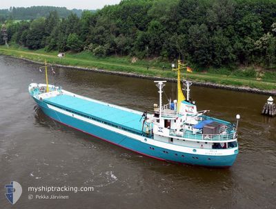
HEIN
General Cargo
Current Trip
| Time Travelled | 17 h, 54 mins |
|---|---|
| Remaining Time | --- |
| Distance Travelled | 151.30 nm |
| Remaining Distance | --- |
| AVG Speed | 8.3 Knop |
| MAX Speed | 9.3 Knop |
| AVG Wind | 10.8 knots |
| MAX Wind | 12 knots |
| MIN Temp | 26.4°C / 79.52°F |
| MAX Temp | 27.8°C / 82.04°F |
| Djupgående | 2.5 m |
| Position mottagen | 4 h, 48 m sen |
Current Position
| Longitud | -66.16255° |
|---|---|
| Latitude | 17.68863° |
| Status | Under way using engine |
| Fart | 8.8 Knop |
| Kurs | 259.5° |
| Område | Caribbean Sea |
| Station | T-AIS |
| Position mottagen | 4 h, 48 m sen |
Info
Information
The current position of HEIN is in Caribbean Sea with coordinates 17.68863° / -66.16255° as reported on 2024-04-24 13:22 by AIS to our vessel tracker app. The vessel's current speed is 8.8 Knop and is heading at the port of SAN PEDRO. The estimated time of arrival as calculated by MyShipTracking vessel tracking app is 2024-04-25 08:00 LT
The vessel HEIN (IMO: 6702284, MMSI: 750000045) is a General Cargo that was built in 1966 ( 58 År gammal ). It's sailing under the flag of [GY] Guyana.
In this page you can find informations about the vessels current position, last detected port calls, and current voyage information. If the vessels is not in coverage by AIS you will find the latest position.
The current position of HEIN is detected by our AIS receivers and we are not responsible for the reliability of the data. The last position was recorded while the vessel was in Coverage by the Ais receivers of our vessel tracking app.
The current draught of HEIN as reported by AIS is 2.5 meters
Weather
| Temperature | 27.9°C / 82.22°F |
|---|---|
| Wind Speed | 9 knots |
| Direction | 110° ESE |
| Pressure | 1014.2 hPa |
| Humidity | 72.9 % |
| Cloud Coverage | 19 % |
Featured Company
Last Port Calls
| Port | Arrival | Departure | Time In Port |
|---|---|---|---|
| 2024-04-23 12:15 | 2024-04-24 00:16 | 12 h | |
| 2024-04-18 14:38 | 2024-04-18 20:26 | 5 h | |
| 2024-04-10 03:51 | 2024-04-13 11:16 | 3 d | |
| 2024-03-01 16:31 | |||
| 2024-02-23 17:25 | 2024-02-25 15:57 | 1 d | |
| 2024-02-10 11:08 | 2024-02-19 15:04 | 9 d | |
| 2024-02-08 09:59 | 2024-02-08 22:56 | 12 h | |
| 2024-02-07 09:36 | 2024-02-07 21:09 | 11 h | |
| 2024-02-02 12:29 | 2024-02-03 04:29 | 15 h |
Most Visited Ports (Last year)
| Port | Arrivals | |
|---|---|---|
| 12 | ||
| 8 | ||
| 5 | ||
| 5 | ||
| 5 | ||
| 3 |
Last Trips
| Origin | Departure | Destination | Arrival | Distance | |
|---|---|---|---|---|---|
| 2024-04-18 16:26 | 2024-04-23 08:15 | 93.50 nm | |||
| 2024-04-13 07:16 | 2024-04-18 10:38 | 546.23 nm | |||
| 2024-03-01 12:31 | 2024-04-09 23:51 | 1614.15 nm | |||
| 2024-02-19 11:04 | 2024-02-23 13:25 | 446.29 nm | |||
| 2024-02-08 18:56 | 2024-02-10 07:08 | 210.74 nm | |||
| 2024-02-07 17:09 | 2024-02-08 05:59 | 25.22 nm | |||
| 2024-02-03 00:29 | 2024-02-07 05:36 | 549.78 nm | |||
| 2024-01-31 14:29 | 2024-02-02 08:29 | 374.48 nm |
Events
| Tid | Event | Detaljer | Position / Dest | Information |
|---|---|---|---|---|
| 2024-04-24 14:13 | Status ändrad | Default Under way using engine |
17.67156 / -66.29456
SAN PEDRO DR
|
Fart: 8.8 kn Kurs: 259.5° |
| 2024-04-24 13:22 | UTANFÖR täckningsområde |
17.68863 / -66.16255
Caribbean Sea
SAN PEDRO DR
|
Fart: 8.8 kn Kurs: 259.5° |
|
| 2024-04-24 13:17 | Status ändrad | Under way using engine Default |
17.69039 / -66.14896
SAN PEDRO DR
|
Fart: 8.7 kn Kurs: 259° |
| 2024-04-24 13:17 | I täckningsområde |
17.69039 / -66.14896
Caribbean Sea
SAN PEDRO DR
|
Fart: 8.7 kn Kurs: 264.9° |
|
| 2024-04-24 12:29 | Status ändrad | Default Under way using engine |
17.70655 / -66.02833
SAN PEDRO DR
|
Fart: 8.8 kn Kurs: 261° |
| 2024-04-24 11:56 | UTANFÖR täckningsområde |
17.71601 / -65.94404
Caribbean Sea
SAN PEDRO DR
|
Fart: 8.8 kn Kurs: 261° |
|
| 2024-04-24 11:39 | Status ändrad | Under way using engine Default |
17.72182 / -65.90073
SAN PEDRO DR
|
Fart: 9 kn Kurs: 261° |
| 2024-04-24 11:34 | I täckningsområde |
17.72182 / -65.90073
Caribbean Sea
SAN PEDRO DR
|
Fart: 8.9 kn Kurs: 262.8° |
|
| 2024-04-24 07:20 | Status ändrad | Default Under way using engine |
17.89937 / -65.26304
SAN PEDRO DR
|
Fart: 9 kn Kurs: 244° |
| 2024-04-24 07:01 | UTANFÖR täckningsområde |
17.92265 / -65.21920
Caribbean Sea
SAN PEDRO DR
|
Fart: 9 kn Kurs: 244° |