
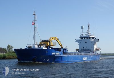
HAV SAGA
General Cargo
Current Trip
| Time Travelled | 1 day |
|---|---|
| Remaining Time | --- |
| Distance Travelled | 270.34 nm |
| Remaining Distance | --- |
| AVG Speed | 9.6 Knop |
| MAX Speed | 14 Knop |
| AVG Wind | 16.7 knots |
| MAX Wind | 31 knots |
| MIN Temp | 2.9°C / 37.22°F |
| MAX Temp | 6.2°C / 43.16°F |
| Djupgående | 5.4 m |
| Position mottagen | 1 m sen |
Current Position
| Longitud | 5.34006° |
|---|---|
| Latitude | 59.27065° |
| Status | Under way using engine |
| Fart | 7.1 Knop |
| Kurs | 351.7° |
| Område | North Sea |
| Station | T-AIS |
| Position mottagen | 1 m sen |
Info
Information
The current position of HAV SAGA is in North Sea with coordinates 59.27065° / 5.34006° as reported on 2024-04-20 05:12 by AIS to our vessel tracker app. The vessel's current speed is 7.1 Knop and is heading at the port of HUSOY. The estimated time of arrival as calculated by MyShipTracking vessel tracking app is 2024-04-20 08:00 LT
The vessel HAV SAGA (IMO: 8719073, MMSI: 231108000) is a General Cargo that was built in 1990 ( 34 År gammal ). It's sailing under the flag of [FO] Faroe Is.
In this page you can find informations about the vessels current position, last detected port calls, and current voyage information. If the vessels is not in coverage by AIS you will find the latest position.
The current position of HAV SAGA is detected by our AIS receivers and we are not responsible for the reliability of the data. The last position was recorded while the vessel was in Coverage by the Ais receivers of our vessel tracking app.
The current draught of HAV SAGA as reported by AIS is 5.4 meters
Weather
| Temperature | 4.5°C / 40.1°F |
|---|---|
| Wind Speed | 31 knots |
| Direction | 339° NNW |
| Pressure | 1017.2 hPa |
| Humidity | 74.1 % |
| Cloud Coverage | 82 % |
Featured Company
Last Port Calls
| Port | Arrival | Departure | Time In Port |
|---|---|---|---|
| 2024-04-18 05:56 | 2024-04-18 16:21 | 10 h | |
| 2024-04-12 14:48 | 2024-04-12 16:02 | 1 h | |
| 2024-04-10 09:28 | 2024-04-12 04:06 | 1 d | |
| 2024-04-07 07:31 | 2024-04-08 14:00 | 1 d | |
| 2024-04-06 07:38 | 2024-04-07 02:39 | 19 h | |
| 2024-04-02 19:43 | 2024-04-04 00:11 | 1 d | |
| 2024-04-01 21:10 | 2024-04-02 18:57 | 21 h | |
| 2024-03-29 07:20 | 2024-03-30 10:13 | 1 d | |
| 2024-03-26 09:53 | 2024-03-27 13:28 | 1 d | |
| 2024-03-22 15:52 |
Most Visited Ports (Last year)
| Port | Arrivals | |
|---|---|---|
| 10 | ||
| 4 | ||
| 4 | ||
| 4 | ||
| 4 | ||
| 4 |
Last Trips
| Origin | Departure | Destination | Arrival | Distance | |
|---|---|---|---|---|---|
| 2024-04-12 18:02 | 2024-04-18 07:56 | 1124.99 nm | |||
| 2024-04-12 06:06 | 2024-04-12 16:48 | 116.77 nm | |||
| 2024-04-08 16:00 | 2024-04-10 11:28 | 251.65 nm | |||
| 2024-04-07 04:39 | 2024-04-07 09:31 | 43.02 nm | |||
| 2024-04-04 01:11 | 2024-04-06 09:38 | 486.03 nm | |||
| 2024-04-02 19:57 | 2024-04-02 20:43 | 5.72 nm | |||
| 2024-03-30 11:13 | 2024-04-01 22:10 | 441.42 nm | |||
| 2024-03-27 14:28 | 2024-03-29 08:20 | 412.67 nm | |||
| 2024-03-22 15:52 | 2024-03-26 10:53 | 788.27 nm | |||
| 2024-03-16 11:37 | 2024-03-18 13:26 | 441.33 nm |
Events
| Tid | Event | Detaljer | Position / Dest | Information |
|---|---|---|---|---|
| 2024-04-19 22:15 | Status ändrad | Under way using engine Moored |
58.38738 / 5.99809
HUSOY
|
Fart: 9.2 kn Kurs: 175.7° |
| 2024-04-19 22:14 | Djupgående ändrat | 5.4 4.5 |
58.39240 / 5.99828
HUSOY
|
Fart: 9.2 kn Kurs: 175.7° |
| 2024-04-19 22:14 | Destination ändrad | HUSOY EGERSUND |
58.39240 / 5.99828
HUSOY
|
Fart: 9.2 kn Kurs: 175.7° |
| 2024-04-19 22:14 | ETA ändrat | 2024/04/20 08:00 2024/04/19 14:00 |
58.39240 / 5.99828
HUSOY
|
Fart: 9.2 kn Kurs: 175.7° |
| 2024-04-19 21:52 | STARTAR förflyttning | 0.96 nm, South of EGERSUND |
58.43536 / 5.98930
EGERSUND
|
Fart: 3.5 kn Kurs: 175° |
| 2024-04-19 12:37 | Status ändrad | Moored Under way using engine |
58.43710 / 5.98973
EGERSUND
|
Fart: Kurs: 193° |
| 2024-04-19 10:23 | STOPPAR förflyttning | 0.85 nm, South of EGERSUND |
58.43764 / 5.98739
EGERSUND
|
Fart: 0.2 kn Kurs: 146° |
| 2024-04-19 05:19 | Byter havsområde | Norwegian part of the North Sea Norwegian part of the Skaggerak |
57.95600 / 7.06640
North Sea
EGERSUND
|
Fart: 11.4 kn Kurs: 289.9° |
| 2024-04-18 18:24 | ETA ändrat | 2024/04/19 14:00 2024/04/19 19:00 |
59.06323 / 10.59910
EGERSUND
|
Fart: 10.8 kn Kurs: 196.2° |
| 2024-04-18 16:21 | AVGÅTT HAMN |
|
59.41984 / 10.64978
EGERSUND
|
Fart: 6.2 kn Kurs: 198° |