
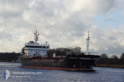
FALSTRIA SWAN
Oil/Chemical Tanker
Current Trip
| Time Travelled | 1 day |
|---|---|
| Remaining Time | 14 h, 15 mins |
| Distance Travelled | 337.90 nm |
| Remaining Distance | 165.62 nm |
| AVG Speed | 8.6 Knop |
| MAX Speed | 12.5 Knop |
| AVG Wind | 9.9 knots |
| MAX Wind | 21.3 knots |
| MIN Temp | 2°C / 35.6°F |
| MAX Temp | 8.3°C / 46.94°F |
| Djupgående | 5.2 m |
| Position mottagen | 1 h, 49 m sen |
Current Position
| Longitud | 4.74362° |
|---|---|
| Latitude | 53.49789° |
| Status | Under way using engine |
| Fart | 11.7 Knop |
| Kurs | 248.3° |
| Område | North Sea |
| Station | T-AIS |
| Position mottagen | 1 h, 49 m sen |
Info
Information
The current position of FALSTRIA SWAN is in North Sea with coordinates 53.49789° / 4.74362° as reported on 2024-04-25 12:04 by AIS to our vessel tracker app. The vessel's current speed is 11.7 Knop and is heading at the port of ANTWERP. The estimated time of arrival as calculated by MyShipTracking vessel tracking app is 2024-04-26 04:08 LT
The vessel FALSTRIA SWAN (IMO: 9367217, MMSI: 304955000) is a Oil/Chemical Tanker that was built in 2006 ( 18 År gammal ). It's sailing under the flag of [AG] Antigua Barbuda.
In this page you can find informations about the vessels current position, last detected port calls, and current voyage information. If the vessels is not in coverage by AIS you will find the latest position.
The current position of FALSTRIA SWAN is detected by our AIS receivers and we are not responsible for the reliability of the data. The last position was recorded while the vessel was in Coverage by the Ais receivers of our vessel tracking app.
The current draught of FALSTRIA SWAN as reported by AIS is 5.2 meters
Weather
| Temperature | 6.9°C / 44.42°F |
|---|---|
| Wind Speed | 20 knots |
| Direction | 230° SW |
| Pressure | 1001.4 hPa |
| Humidity | 84.5 % |
| Cloud Coverage | 100 % |
Featured Company
Last Port Calls
| Port | Arrival | Departure | Time In Port |
|---|---|---|---|
| 2024-04-22 21:46 | 2024-04-23 23:36 | 1 d | |
| 2024-04-18 15:29 | 2024-04-19 20:33 | 1 d | |
| 2024-04-17 11:58 | 2024-04-18 03:29 | 15 h | |
| 2024-04-12 22:44 | 2024-04-14 12:29 | 1 d | |
| 2024-04-07 19:16 | 2024-04-09 00:06 | 1 d | |
| 2024-03-30 11:46 | 2024-03-31 16:41 | 1 d | |
| 2024-03-25 23:21 | 2024-03-28 23:04 | 2 d | |
| 2024-03-22 15:53 | 2024-03-23 22:04 | 1 d | |
| 2024-03-18 13:50 | 2024-03-19 20:33 | 1 d | |
| 2024-03-13 06:59 | 2024-03-16 20:26 | 3 d |
Most Visited Ports (Last year)
| Port | Arrivals | |
|---|---|---|
| 14 | ||
| 11 | ||
| 9 | ||
| 8 | ||
| 6 | ||
| 5 |
Last Trips
| Origin | Departure | Destination | Arrival | Distance | |
|---|---|---|---|---|---|
| 2024-04-19 21:33 | 2024-04-22 23:46 | 666.12 nm | |||
| 2024-04-18 05:29 | 2024-04-18 16:29 | 125.45 nm | |||
| 2024-04-14 14:29 | 2024-04-17 13:58 | 117.75 nm | |||
| 2024-04-09 02:06 | 2024-04-13 00:44 | 389.07 nm | |||
| 2024-03-31 18:41 | 2024-04-07 21:16 | 195.36 nm | |||
| 2024-03-29 00:04 | 2024-03-30 12:46 | 346.25 nm | |||
| 2024-03-23 23:04 | 2024-03-26 00:21 | 374.41 nm | |||
| 2024-03-19 21:33 | 2024-03-22 16:53 | 354.26 nm | |||
| 2024-03-16 21:26 | 2024-03-18 14:50 | 281.01 nm | |||
| 2024-03-11 21:22 | 2024-03-13 07:59 | 160.10 nm |
Events
| Tid | Event | Detaljer | Position / Dest | Information |
|---|---|---|---|---|
| 2024-04-25 12:08 | Status ändrad | Default Under way using engine |
53.49166 / 4.72333
BE ANR
|
Fart: 11.7 kn Kurs: 248.3° |
| 2024-04-25 12:04 | UTANFÖR täckningsområde |
53.49789 / 4.74362
North Sea
BE ANR
|
Fart: 11.7 kn Kurs: 248.3° |
|
| 2024-04-25 08:31 | Destination ändrad | BE ANR BE ANR VIA NOK |
53.71148 / 5.76831
BE ANR
|
Fart: 10.1 kn Kurs: 254.7° |
| 2024-04-25 08:03 | Upptäckt i hav | Dutch part of the North Sea |
53.73440 / 5.88977
North Sea
BE ANR VIA NOK
|
Fart: 9.6 kn Kurs: 255.4° |
| 2024-04-25 08:03 | Status ändrad | Under way using engine Default |
53.73440 / 5.88977
BE ANR VIA NOK
|
Fart: 9.6 kn Kurs: 256° |
| 2024-04-25 07:56 | I täckningsområde |
53.73440 / 5.88977
North Sea
BE ANR VIA NOK
|
Fart: 9.6 kn Kurs: 255.4° |
|
| 2024-04-25 04:43 | Status ändrad | Default Under way using engine |
53.89919 / 6.86446
BE ANR VIA NOK
|
Fart: 12.1 kn Kurs: 255.2° |
| 2024-04-25 04:41 | UTANFÖR täckningsområde |
53.90155 / 6.87914
North Sea
BE ANR VIA NOK
|
Fart: 12.1 kn Kurs: 255.2° |
|
| 2024-04-25 04:07 | Status ändrad | Under way using engine Default |
53.92833 / 7.06963
BE ANR VIA NOK
|
Fart: 11 kn Kurs: 255° |
| 2024-04-25 04:02 | Status ändrad | Default Under way using engine |
53.93167 / 7.09333
BE ANR VIA NOK
|
Fart: 11.9 kn Kurs: 256.2° |