
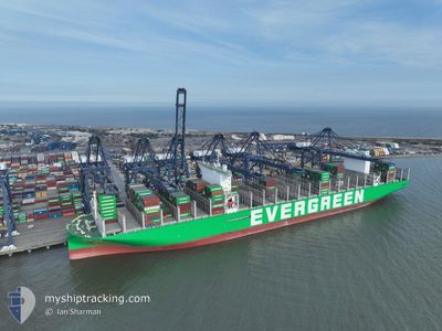
EVER ALP
Cargo D
Current Trip
| Time Travelled | 8 days |
|---|---|
| Remaining Time | --- |
| Distance Travelled | 131.72 nm |
| Remaining Distance | 0.94 nm |
| AVG Speed | 8.1 Knop |
| MAX Speed | 13 Knop |
| AVG Wind | 17.1 knots |
| MAX Wind | 34.6 knots |
| MIN Temp | 5°C / 41°F |
| MAX Temp | 10.5°C / 50.9°F |
| Djupgående | 12.5 m |
| Position mottagen | 1 m sen |
Current Position
| Longitud | 1.31379° |
|---|---|
| Latitude | 51.94809° |
| Status | Moored |
| Fart | |
| Kurs | 162° |
| Område | North Sea |
| Station | T-AIS |
| Position mottagen | 1 m sen |
Info
Information
The current position of EVER ALP is in North Sea with coordinates 51.94809° / 1.31379° as reported on 2024-04-23 18:12 by AIS to our vessel tracker app. The vessel's current speed is 0 Knop and is heading at the port of FELIXSTOWE. The estimated time of arrival as calculated by MyShipTracking vessel tracking app is 2024-04-15 19:00 LT
The vessel EVER ALP (IMO: 9893929, MMSI: 352898717) is a Cargo D It's sailing under the flag of [PA] Panama.
In this page you can find informations about the vessels current position, last detected port calls, and current voyage information. If the vessels is not in coverage by AIS you will find the latest position.
The current position of EVER ALP is detected by our AIS receivers and we are not responsible for the reliability of the data. The last position was recorded while the vessel was in Coverage by the Ais receivers of our vessel tracking app.
The current draught of EVER ALP as reported by AIS is 12.5 meters
Weather
| Temperature | 6.9°C / 44.42°F |
|---|---|
| Wind Speed | 15 knots |
| Direction | 347° NNW |
| Pressure | 1020.1 hPa |
| Humidity | 70.7 % |
| Cloud Coverage | 92 % |
Featured Company
Last Port Calls
| Port | Arrival | Departure | Time In Port |
|---|---|---|---|
| 2024-04-13 07:41 | 2024-04-15 10:13 | 2 d | |
| 2024-03-16 16:12 | 2024-03-17 15:18 | 23 h | |
| 2024-03-09 10:23 | 2024-03-10 14:18 | 1 d | |
| 2024-03-06 23:21 | 2024-03-07 18:29 | 19 h | |
| 2024-03-03 00:32 | |||
| 2024-02-28 17:14 | 2024-03-01 13:15 | 1 d | |
| 2024-02-25 06:41 | 2024-02-26 03:42 | 21 h | |
| 2024-02-19 10:47 | 2024-02-20 11:58 | 1 d | |
| 2024-02-14 20:03 | 2024-02-15 09:23 | 13 h |
Most Visited Ports (Last year)
| Port | Arrivals | |
|---|---|---|
| 7 | ||
| 5 | ||
| 5 | ||
| 4 | ||
| 4 | ||
| 4 |
Last Trips
| Origin | Departure | Destination | Arrival | Distance | |
|---|---|---|---|---|---|
| 2024-03-17 23:18 | 2024-04-13 09:41 | 11871.31 nm | |||
| 2024-03-10 22:18 | 2024-03-17 00:12 | 1490.20 nm | |||
| 2024-03-08 02:29 | 2024-03-09 18:23 | 477.56 nm | |||
| 2024-03-01 21:15 | 2024-03-03 08:32 | 469.87 nm | |||
| 2024-02-26 11:42 | 2024-02-29 01:14 | 948.97 nm | |||
| 2024-02-20 19:58 | 2024-02-25 14:41 | 1647.58 nm | |||
| 2024-02-15 14:53 | 2024-02-19 18:47 | 1598.69 nm | |||
| 2024-01-20 01:04 | 2024-02-15 01:33 | 10667.83 nm |
Events
| Tid | Event | Detaljer | Position / Dest | Information |
|---|---|---|---|---|
| 2024-04-23 11:29 | Status ändrad | Moored Under way using engine |
51.94796 / 1.31367
NLRTM>GBFXT
|
Fart: Kurs: 162° |
| 2024-04-23 11:07 | STOPPAR förflyttning | 0.8 nm, South East of FELIXSTOWE |
51.94745 / 1.31070
NLRTM>GBFXT
|
Fart: 0.2 kn Kurs: 107° |
| 2024-04-23 08:13 | STARTAR förflyttning | 15.36 nm, East of FELIXSTOWE |
51.88837 / 1.69692
NLRTM>GBFXT
|
Fart: 3.1 kn Kurs: 128° |
| 2024-04-23 07:57 | Status ändrad | Under way using engine At anchor |
51.89554 / 1.69053
NLRTM>GBFXT
|
Fart: 0.8 kn Kurs: 33° |
| 2024-04-22 13:58 | Status ändrad | At anchor Under way using engine |
51.89875 / 1.69283
NLRTM>GBFXT
|
Fart: Kurs: 0° |
| 2024-04-22 13:55 | Status ändrad | Under way using engine At anchor |
51.89871 / 1.69283
NLRTM>GBFXT
|
Fart: Kurs: 184° |
| 2024-04-15 19:31 | Status ändrad | At anchor Under way using engine |
51.89699 / 1.69232
NLRTM>GBFXT
|
Fart: 0.5 kn Kurs: 256° |
| 2024-04-15 19:28 | STOPPAR förflyttning | 15.05 nm, East of FELIXSTOWE |
51.89674 / 1.69209
NLRTM>GBFXT
|
Fart: 0.3 kn Kurs: 261° |
| 2024-04-15 15:26 | Byter havsområde | United Kingdom part of the North Sea Dutch part of the North Sea |
52.02554 / 2.66104
North Sea
NLRTM>GBFXT
|
Fart: 11.3 kn Kurs: 250.3° |
| 2024-04-15 11:22 | ETA ändrat | 2024/04/15 19:00 2024/04/18 18:00 |
52.05349 / 3.89980
NLRTM>GBFXT
|
Fart: 9.5 kn Kurs: 286.4° |