
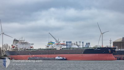
CLARET PRINCE
Crude Oil Tanker
Current Trip
| Time Travelled | 10 days |
|---|---|
| Remaining Time | --- |
| Distance Travelled | 1149.62 nm |
| Remaining Distance | --- |
| AVG Speed | 11.1 Knop |
| MAX Speed | 14 Knop |
| AVG Wind | 14.1 knots |
| MAX Wind | 27.9 knots |
| MIN Temp | 15.1°C / 59.18°F |
| MAX Temp | 29.9°C / 85.82°F |
| Djupgående | 8.2 m |
| Position mottagen | 3 d sen |
Current Position
| Longitud | -97.49485° |
|---|---|
| Latitude | 27.83081° |
| Status | Moored |
| Fart | |
| Kurs | 111° |
| Område | Gulf of Mexico |
| Station | T-AIS |
| Position mottagen | 3 d sen |
Info
Information
The current position of CLARET PRINCE is in Gulf of Mexico with coordinates 27.83081° / -97.49485° as reported on 2024-04-12 09:18 by AIS to our vessel tracker app. The vessel's current speed is 0 Knop and is heading at the port of ROTTERDAM.
The vessel CLARET PRINCE (IMO: 9437983, MMSI: 538008071) is a Crude Oil Tanker that was built in 2010 ( 14 År gammal ). It's sailing under the flag of [MH] Marshall Is.
In this page you can find informations about the vessels current position, last detected port calls, and current voyage information. If the vessels is not in coverage by AIS you will find the latest position.
The current position of CLARET PRINCE is detected by our AIS receivers and we are not responsible for the reliability of the data. The last position was recorded while the vessel was in Coverage by the Ais receivers of our vessel tracking app.
The current draught of CLARET PRINCE as reported by AIS is 8.2 meters
Weather
| Temperature | 24°C / 75.2°F |
|---|---|
| Wind Speed | 14 knots |
| Direction | 86° E |
| Pressure | 1017.2 hPa |
| Humidity | 68.1 % |
| Cloud Coverage | --- |
Featured Company
Last Port Calls
| Port | Arrival | Departure | Time In Port |
|---|---|---|---|
| 2024-04-03 15:51 | 2024-04-05 13:41 | 1 d | |
| 2024-03-05 00:28 | 2024-03-06 07:40 | 1 d | |
| 2024-02-26 01:29 | 2024-02-29 23:42 | 3 d | |
| 2024-02-18 16:07 | 2024-02-20 14:09 | 1 d | |
| 2024-02-09 11:32 |
Most Visited Ports (Last year)
| Port | Arrivals | |
|---|---|---|
| 3 | ||
| 2 | ||
| 2 | ||
| 1 | ||
| 1 | ||
| 1 |
Last Trips
| Origin | Departure | Destination | Arrival | Distance | |
|---|---|---|---|---|---|
| 2024-03-06 01:40 | 2024-04-03 10:51 | 4894.82 nm | |||
| 2024-02-29 17:42 | 2024-03-04 18:28 | 859.82 nm | |||
| 2024-02-20 08:09 | 2024-02-25 19:29 | 828.39 nm | |||
| 2024-02-09 05:32 | 2024-02-18 10:07 | 1569.37 nm |
Events
| Tid | Event | Detaljer | Position / Dest | Information |
|---|---|---|---|---|
| 2024-04-13 06:17 | STARTAR förflyttning |
27.77340 / -96.36335
NL RTM
|
Fart: 3.4 kn Kurs: 160° |
|
| 2024-04-12 20:23 | STOPPAR förflyttning |
27.77667 / -96.36166
NL RTM
|
Fart: Kurs: -1° |
|
| 2024-04-12 13:12 | STARTAR förflyttning | 5.83 nm, West of CORPUS CHRISTI |
27.82811 / -97.49202
NL RTM
|
Fart: 3.1 kn Kurs: 132° |
| 2024-04-12 09:22 | Status ändrad | Default Moored |
27.83081 / -97.49483
NL RTM
|
Fart: Kurs: 111° |
| 2024-04-12 09:18 | UTANFÖR täckningsområde |
27.83081 / -97.49485
Gulf of Mexico
|
Fart: Kurs: 357.7° |
|
| 2024-04-12 09:09 | Status ändrad | Moored Default |
27.83078 / -97.49482
NL RTM
|
Fart: Kurs: 111° |
| 2024-04-12 09:06 | Status ändrad | Default Moored |
27.83079 / -97.49484
NL RTM
|
Fart: Kurs: 111° |
| 2024-04-12 08:51 | Status ändrad | Moored Default |
27.83079 / -97.49482
NL RTM
|
Fart: Kurs: -1° |
| 2024-04-12 08:46 | Status ändrad | Default Moored |
27.83000 / -97.49333
NL RTM
|
Fart: Kurs: 110° |
| 2024-04-12 08:46 | Destination ändrad | NL RTM USCRP |
27.83081 / -97.49485
NL RTM
|
Fart: Kurs: 110° |