
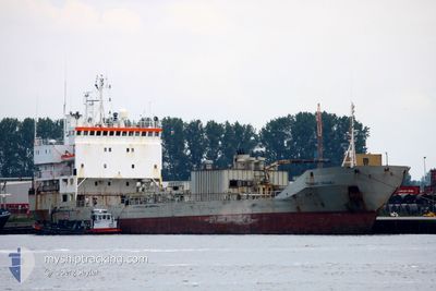
CEMENT TRADER
Cement Carrier
Current Trip
| Time Travelled | 1 day |
|---|---|
| Remaining Time | 2 days |
| Distance Travelled | 386.37 nm |
| Remaining Distance | 743.48 nm |
| AVG Speed | 10.7 Knop |
| MAX Speed | 14.3 Knop |
| AVG Wind | 9.7 knots |
| MAX Wind | 20 knots |
| MIN Temp | 3°C / 37.4°F |
| MAX Temp | 11.7°C / 53.06°F |
| Djupgående | 4.7 m |
| Position mottagen | 2 m sen |
Current Position
| Longitud | -5.32508° |
|---|---|
| Latitude | 49.08503° |
| Status | Under way using engine |
| Fart | 11.9 Knop |
| Kurs | 238.9° |
| Område | Celtic Sea |
| Station | T-AIS |
| Position mottagen | 2 m sen |
Info
Information
The current position of CEMENT TRADER is in Celtic Sea with coordinates 49.08503° / -5.32508° as reported on 2024-04-19 16:13 by AIS to our vessel tracker app. The vessel's current speed is 11.9 Knop and is heading at the port of SETUBAL. The estimated time of arrival as calculated by MyShipTracking vessel tracking app is 2024-04-22 09:56 LT
The vessel CEMENT TRADER (IMO: 7716763, MMSI: 304048000) is a Cement Carrier that was built in 1980 ( 44 År gammal ). It's sailing under the flag of [AG] Antigua Barbuda.
In this page you can find informations about the vessels current position, last detected port calls, and current voyage information. If the vessels is not in coverage by AIS you will find the latest position.
The current position of CEMENT TRADER is detected by our AIS receivers and we are not responsible for the reliability of the data. The last position was recorded while the vessel was in Coverage by the Ais receivers of our vessel tracking app.
The current draught of CEMENT TRADER as reported by AIS is 4.7 meters
Weather
| Temperature | 11.6°C / 52.88°F |
|---|---|
| Wind Speed | 14 knots |
| Direction | 337° NNW |
| Pressure | 1023.2 hPa |
| Humidity | 87.4 % |
| Cloud Coverage | 13 % |
Featured Company
Last Port Calls
| Port | Arrival | Departure | Time In Port |
|---|---|---|---|
| 2024-04-18 03:39 | 2024-04-18 05:14 | 1 h | |
| 2024-04-16 03:44 | 2024-04-18 03:06 | 1 d | |
| 2024-04-16 02:31 | 2024-04-16 02:33 | 1 m | |
| 2024-04-02 22:12 | 2024-04-04 22:14 | 2 d | |
| 2024-04-02 20:11 | 2024-04-02 20:13 | 2 m | |
| 2024-03-12 03:13 | 2024-03-14 03:36 | 2 d | |
| 2024-03-02 00:45 | 2024-03-04 09:12 | 2 d | |
| 2024-03-02 00:21 | 2024-03-02 00:38 | 16 m | |
| 2024-02-11 15:01 | 2024-02-14 00:15 | 2 d | |
| 2024-02-11 14:25 | 2024-02-11 14:38 | 13 m |
Last Trips
| Origin | Departure | Destination | Arrival | Distance | |
|---|---|---|---|---|---|
| 2024-04-18 05:06 | 2024-04-18 05:39 | 2.03 nm | |||
| 2024-04-16 04:33 | 2024-04-16 05:44 | 4.15 nm | |||
| 2024-04-05 00:14 | 2024-04-16 04:31 | 2294.43 nm | |||
| 2024-04-02 22:13 | 2024-04-03 00:12 | 4.63 nm | |||
| 2024-03-14 04:36 | 2024-04-02 22:11 | 2468.74 nm | |||
| 2024-03-04 10:12 | 2024-03-12 04:13 | 1415.56 nm | |||
| 2024-03-02 01:38 | 2024-03-02 01:45 | 1.01 nm | |||
| 2024-02-14 01:15 | 2024-03-02 01:21 | 2330.50 nm | |||
| 2024-02-11 15:38 | 2024-02-11 16:01 | 0.30 nm | |||
| 2024-01-23 03:13 | 2024-02-11 15:25 | 2387.70 nm |
Events
| Tid | Event | Detaljer | Position / Dest | Information |
|---|---|---|---|---|
| 2024-04-19 16:10 | Status ändrad | Under way using engine Default |
49.09001 / -5.31300
PT SET
|
Fart: 11.7 kn Kurs: 240° |
| 2024-04-19 15:49 | Status ändrad | Default Under way using engine |
49.12279 / -5.22708
PT SET
|
Fart: 11.5 kn Kurs: 239.4° |
| 2024-04-19 15:01 | Byter havsområde | French part of the Celtic Sea French part of the English Channel |
49.19839 / -5.02770
Celtic Sea
PT SET
|
Fart: 11 kn Kurs: 240.4° |
| 2024-04-19 13:41 | I täckningsområde |
49.31712 / -4.71950
English Channel
PT SET
|
Fart: 10.8 kn Kurs: 238.9° |
|
| 2024-04-19 12:00 | Status ändrad | Default Under way using engine |
49.47436 / -4.30190
PT SET
|
Fart: 11.4 kn Kurs: 240.4° |
| 2024-04-19 11:51 | UTANFÖR täckningsområde |
49.48749 / -4.26607
English Channel
PT SET
|
Fart: 11.4 kn Kurs: 240.4° |
|
| 2024-04-19 11:47 | Status ändrad | Under way using engine Default |
49.49507 / -4.24495
PT SET
|
Fart: 11.5 kn Kurs: 242° |
| 2024-04-19 11:32 | Status ändrad | Default Under way using engine |
49.51606 / -4.18485
PT SET
|
Fart: 11.5 kn Kurs: 241.7° |
| 2024-04-19 11:32 | Status ändrad | Under way using engine Default |
49.51729 / -4.18131
PT SET
|
Fart: 11.8 kn Kurs: 242° |
| 2024-04-19 11:32 | Upptäckt i hav | French part of the English Channel |
49.51729 / -4.18131
English Channel
PT SET
|
Fart: 11.5 kn Kurs: 241.7° |