
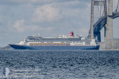
BOREALIS
Passengers Ship
Current Trip
| Time Travelled | 30 mins |
|---|---|
| Remaining Time | --- |
| Distance Travelled | 5.22 nm |
| Remaining Distance | --- |
| AVG Speed | 12.7 Knop |
| MAX Speed | 15.9 Knop |
| AVG Wind | 7 knots |
| MAX Wind | 7 knots |
| MIN Temp | 6.8°C / 44.24°F |
| MAX Temp | 6.9°C / 44.42°F |
| Djupgående | 8.4 m |
| Position mottagen | Nu |
Current Position
| Longitud | --- |
|---|---|
| Latitude | --- |
| Status | Under way using engine |
| Fart | 16.3 Knop |
| Kurs | 111.3° |
| Område | English Channel |
| Station | T-AIS |
| Position mottagen | Nu |
Info
Information
The current position of BOREALIS is in English Channel with coordinates 50.71698° / -1.00076° as reported on 2025-02-27 18:48 by AIS to our vessel tracker app. The vessel's current speed is 16.3 Knop and is heading at the port of CORUNA. The estimated time of arrival as calculated by MyShipTracking vessel tracking app is 2025-03-01 06:30 LT
The vessel BOREALIS (IMO: 9122552, MMSI: 311000987) is a Passengers Ship that was built in 1997 ( 28 År gammal ). It's sailing under the flag of [BS] Bahamas.
In this page you can find informations about the vessels current position, last detected port calls, and current voyage information. If the vessels is not in coverage by AIS you will find the latest position.
The current position of BOREALIS is detected by our AIS receivers and we are not responsible for the reliability of the data. The last position was recorded while the vessel was in Coverage by the Ais receivers of our vessel tracking app.
The current draught of BOREALIS as reported by AIS is 8.4 meters
Weather
| Temperature | 7°C / 44.6°F |
|---|---|
| Wind Speed | 7 knots |
| Direction | 334° NNW |
| Pressure | 1023.9 hPa |
| Humidity | 74 % |
| Cloud Coverage | 7 % |
Featured Company
Last Port Calls
| Port | Arrival | Departure | Time In Port |
|---|---|---|---|
| 2025-02-27 05:37 | 2025-02-27 18:18 | 12 h | |
| 2025-02-24 07:49 | 2025-02-24 18:35 | 10 h | |
| 2025-02-22 18:21 | 2025-02-23 14:07 | 19 h | |
| 2025-02-22 05:19 | 2025-02-22 12:12 | 6 h | |
| 2025-02-21 06:08 | 2025-02-21 22:56 | 16 h | |
| 2025-02-20 11:45 | 2025-02-20 22:27 | 10 h | |
| 2025-02-19 05:08 | 2025-02-19 21:27 | 16 h | |
| 2025-02-15 05:03 | 2025-02-15 19:49 | 14 h | |
| 2025-02-12 07:18 | 2025-02-12 16:04 | 8 h | |
| 2025-02-10 05:49 | 2025-02-10 14:13 | 8 h |
Most Visited Ports (Last year)
| Port | Arrivals | |
|---|---|---|
| 15 | ||
| 7 | ||
| 6 | ||
| 6 | ||
| 6 | ||
| 4 |
Last Trips
| Origin | Departure | Destination | Arrival | Distance | |
|---|---|---|---|---|---|
| 2025-02-24 18:35 | 2025-02-27 05:37 | 907.62 nm | |||
| 2025-02-23 15:07 | 2025-02-24 07:49 | 269.45 nm | |||
| 2025-02-22 13:12 | 2025-02-22 19:21 | 92.00 nm | |||
| 2025-02-21 23:56 | 2025-02-22 06:19 | 75.96 nm | |||
| 2025-02-20 23:27 | 2025-02-21 07:08 | 75.17 nm | |||
| 2025-02-19 22:27 | 2025-02-20 12:45 | 196.65 nm | |||
| 2025-02-15 19:49 | 2025-02-19 06:08 | 1223.65 nm | |||
| 2025-02-12 17:04 | 2025-02-15 05:03 | 702.98 nm | |||
| 2025-02-10 15:13 | 2025-02-12 08:18 | 623.03 nm | |||
| 2025-02-09 16:09 | 2025-02-10 06:49 | 218.66 nm |
Events
| Tid | Event | Detaljer | Position / Dest | Information |
|---|---|---|---|---|
| 2025-02-27 18:18 | AVGÅTT HAMN |
|
50.78685 / -1.10826
ESLCG
|
Fart: 9.6 kn Kurs: 158° |
| 2025-02-27 18:00 | STARTAR förflyttning |
50.81058 / -1.09924
[GB] PORTSMOUTH
|
Fart: 3.1 kn Kurs: 284° |
|
| 2025-02-27 17:55 | Status ändrad | Under way using engine Moored |
50.81055 / -1.09539
[GB] PORTSMOUTH
|
Fart: Kurs: 251° |
| 2025-02-27 15:50 | Destination ändrad | ESLCG GBPME |
50.81060 / -1.09537
[GB] PORTSMOUTH
|
Fart: Kurs: 252° |
| 2025-02-27 15:50 | ETA ändrat | 2025/03/01 06:30 2025/02/27 04:30 |
50.81060 / -1.09537
[GB] PORTSMOUTH
|
Fart: Kurs: 252° |
| 2025-02-27 06:04 | Status ändrad | Moored Under way using engine |
50.81056 / -1.09543
[GB] PORTSMOUTH
|
Fart: 0.1 kn Kurs: 251° |
| 2025-02-27 05:37 | ANLÄNDER HAMN |
|
50.80937 / -1.11246
[GB] PORTSMOUTH
|
Fart: 2 kn Kurs: 251° |
| 2025-02-27 05:30 | STOPPAR förflyttning | 0.55 nm, South West of PORTSMOUTH |
50.80828 / -1.11620
GBPME
|
Fart: 0.2 kn Kurs: 272° |
| 2025-02-27 02:36 | Status ändrad | Under way using engine Default |
50.36093 / -1.47285
GBPME
|
Fart: 13.9 kn Kurs: 59° |
| 2025-02-27 02:36 | Status ändrad | Default Under way using engine |
50.35972 / -1.47613
GBPME
|
Fart: 13.9 kn Kurs: 59° |