
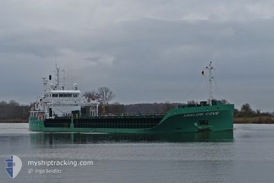
ARKLOW COVE
Cargo
Current Trip
| Trip Time | 1 day |
|---|---|
| Trip Distance | 341.60 nm |
| AVG Speed | 9.3 Knop |
| MAX Speed | 11.1 Knop |
| Djupgående | 6.3 m |
| AVG Wind | 27.6 knots |
| MAX Wind | 34.8 knots |
| MIN Temp | 6.3°C / 43.34°F |
| MAX Temp | 10.2°C / 50.36°F |
| Position mottagen | 4 d sen |
Current Position
| Longitud | -4.54420° |
|---|---|
| Latitude | 51.50194° |
| Status | Under way using engine |
| Fart | 10.6 Knop |
| Kurs | 88.8° |
| Område | Bristol Channel |
| Station | T-AIS |
| Position mottagen | 4 d sen |
Info
Information
The current position of ARKLOW COVE is in Bristol Channel with coordinates 51.50194° / -4.54420° as reported on 2024-04-15 18:19 by AIS to our vessel tracker app. The vessel's current speed is 10.6 Knop and is currently inside the port of PORT TALBOT ANCH.
The vessel ARKLOW COVE (IMO: 9757163, MMSI: 250011434) is a Cargo It's sailing under the flag of [IE] Ireland.
In this page you can find informations about the vessels current position, last detected port calls, and current voyage information. If the vessels is not in coverage by AIS you will find the latest position.
The current position of ARKLOW COVE is detected by our AIS receivers and we are not responsible for the reliability of the data. The last position was recorded while the vessel was in Coverage by the Ais receivers of our vessel tracking app.
The current draught of ARKLOW COVE as reported by AIS is 6.3 meters
Weather
| Temperature | 8.8°C / 47.84°F |
|---|---|
| Wind Speed | 10 knots |
| Direction | 340° NNW |
| Pressure | 1025 hPa |
| Humidity | 71 % |
| Cloud Coverage | 2 % |
Featured Company
Last Port Calls
| Port | Arrival | Departure | Time In Port |
|---|---|---|---|
| 2024-04-15 20:45 | |||
| 2024-04-13 10:38 | 2024-04-14 06:59 | 20 h | |
| 2024-04-11 17:42 | |||
| 2024-04-02 19:39 | 2024-04-06 16:23 | 3 d | |
| 2024-03-28 23:07 | 2024-03-29 23:30 | 1 d | |
| 2024-03-20 06:16 | 2024-03-22 21:38 | 2 d | |
| 2024-03-12 19:37 | 2024-03-16 12:17 | 3 d | |
| 2024-03-07 19:04 | |||
| 2024-02-27 13:15 | 2024-03-03 15:17 | 5 d | |
| 2024-02-18 13:21 | 2024-02-21 19:43 | 3 d |
Last Trips
| Origin | Departure | Destination | Arrival | Distance | |
|---|---|---|---|---|---|
| 2024-04-14 07:59 | 2024-04-15 21:45 | 341.60 nm | |||
| 2024-04-11 18:42 | 2024-04-13 11:38 | 19.75 nm | |||
| 2024-03-29 23:30 | 2024-04-02 21:39 | 670.55 nm | |||
| 2024-03-22 22:38 | 2024-03-28 23:07 | 1289.63 nm | |||
| 2024-03-16 12:17 | 2024-03-20 07:16 | 884.03 nm | |||
| 2024-03-03 15:17 | 2024-03-12 19:37 | 1841.32 nm | |||
| 2024-03-03 15:17 | 2024-03-07 20:04 | 1017.62 nm | |||
| 2024-02-21 19:43 | 2024-02-27 13:15 | 1051.52 nm | |||
| 2024-02-16 02:07 | 2024-02-18 13:21 | 60.98 nm | |||
| 2024-02-10 19:18 | 2024-02-14 20:38 | 934.77 nm |
Events
| Tid | Event | Detaljer | Position / Dest | Information |
|---|---|---|---|---|
| 2024-04-19 00:49 | STOPPAR förflyttning |
51.49177 / -4.03435
[GB] PORT TALBOT ANCH
|
Fart: 0.3 kn Kurs: 274° |
|
| 2024-04-15 20:58 | STOPPAR förflyttning |
51.49173 / -4.03423
[GB] PORT TALBOT ANCH
|
Fart: 0.1 kn Kurs: 258° |
|
| 2024-04-15 20:45 | ANLÄNDER HAMN |
|
51.49111 / -4.03622
[GB] PORT TALBOT ANCH
|
Fart: 0.7 kn Kurs: 263° |
| 2024-04-15 18:25 | Status ändrad | Default Under way using engine |
51.50247 / -4.51792
SWANSEA
|
Fart: 10.6 kn Kurs: 88.8° |
| 2024-04-15 18:19 | UTANFÖR täckningsområde |
51.50194 / -4.54420
Bristol Channel
SWANSEA
|
Fart: 10.6 kn Kurs: 88.8° |
|
| 2024-04-15 18:15 | Status ändrad | Under way using engine Default |
51.50141 / -4.56628
SWANSEA
|
Fart: 10.3 kn Kurs: 87° |
| 2024-04-15 18:09 | Status ändrad | Default Under way using engine |
51.50095 / -4.59209
SWANSEA
|
Fart: 10.2 kn Kurs: 86.5° |
| 2024-04-15 17:58 | Status ändrad | Under way using engine Default |
51.49896 / -4.64113
SWANSEA
|
Fart: 10.5 kn Kurs: 85° |
| 2024-04-15 17:57 | Status ändrad | Default Under way using engine |
51.49871 / -4.64734
SWANSEA
|
Fart: 10.2 kn Kurs: 85° |
| 2024-04-15 17:11 | Byter havsområde | United Kingdom part of the Bristol Channel United Kingdom part of the Celtic Sea |
51.48782 / -4.85581
Bristol Channel
SWANSEA
|
Fart: 10.1 kn Kurs: 87° |