
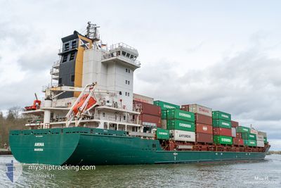
AMINA
Container Ship
Current Trip
| Time Travelled | 1 day |
|---|---|
| Remaining Time | 14 h, 10 mins |
| Distance Travelled | 388.48 nm |
| Remaining Distance | 93.49 nm |
| AVG Speed | 8.5 Knop |
| MAX Speed | 13.9 Knop |
| AVG Wind | 7.7 knots |
| MAX Wind | 16 knots |
| MIN Temp | 2.5°C / 36.5°F |
| MAX Temp | 8.7°C / 47.66°F |
| Djupgående | 7.3 m |
| Position mottagen | Nu |
Current Position
| Longitud | 9.47709° |
|---|---|
| Latitude | 54.18107° |
| Status | Under way using engine |
| Fart | 6.8 Knop |
| Kurs | 250.3° |
| Område | Baltic Sea |
| Station | T-AIS |
| Position mottagen | Nu |
Info
Information
The current position of AMINA is in Baltic Sea with coordinates 54.18107° / 9.47709° as reported on 2024-04-25 15:52 by AIS to our vessel tracker app. The vessel's current speed is 6.8 Knop and is heading at the port of WILHELMSHAVEN. The estimated time of arrival as calculated by MyShipTracking vessel tracking app is 2024-04-26 06:03 LT
The vessel AMINA (IMO: 9448683, MMSI: 255806464) is a Container Ship that was built in 2011 ( 13 År gammal ). It's sailing under the flag of [PT] Portugal.
In this page you can find informations about the vessels current position, last detected port calls, and current voyage information. If the vessels is not in coverage by AIS you will find the latest position.
The current position of AMINA is detected by our AIS receivers and we are not responsible for the reliability of the data. The last position was recorded while the vessel was in Coverage by the Ais receivers of our vessel tracking app.
The current draught of AMINA as reported by AIS is 7.3 meters
Weather
| Temperature | 8.3°C / 46.94°F |
|---|---|
| Wind Speed | 7 knots |
| Direction | 262° W |
| Pressure | 1002.3 hPa |
| Humidity | 66.5 % |
| Cloud Coverage | 100 % |
Featured Company
Last Port Calls
| Port | Arrival | Departure | Time In Port |
|---|---|---|---|
| 2024-04-23 07:13 | 2024-04-24 00:25 | 17 h | |
| 2024-04-20 19:06 | 2024-04-21 23:55 | 1 d | |
| 2024-04-18 03:36 | 2024-04-19 02:07 | 22 h | |
| 2024-04-15 02:17 | 2024-04-16 18:15 | 1 d | |
| 2024-04-12 21:24 | 2024-04-12 21:26 | 2 m | |
| 2024-04-09 22:22 | 2024-04-11 12:09 | 1 d | |
| 2024-04-09 12:35 | 2024-04-09 21:04 | 8 h | |
| 2024-04-08 08:21 | 2024-04-09 10:32 | 1 d | |
| 2024-04-07 14:36 | 2024-04-07 21:08 | 6 h | |
| 2024-04-06 08:56 | 2024-04-06 13:33 | 4 h |
Most Visited Ports (Last year)
| Port | Arrivals | |
|---|---|---|
| 31 | ||
| 23 | ||
| 22 | ||
| 20 | ||
| 11 | ||
| 10 |
Last Trips
| Origin | Departure | Destination | Arrival | Distance | |
|---|---|---|---|---|---|
| 2024-04-22 02:55 | 2024-04-23 09:13 | 472.04 nm | |||
| 2024-04-19 04:07 | 2024-04-20 22:06 | 474.70 nm | |||
| 2024-04-16 21:15 | 2024-04-18 05:36 | 437.41 nm | |||
| 2024-04-12 23:26 | 2024-04-15 05:17 | 647.46 nm | |||
| 2024-04-11 14:09 | 2024-04-12 23:24 | 316.98 nm | |||
| 2024-04-09 23:04 | 2024-04-10 00:22 | 15.60 nm | |||
| 2024-04-09 12:32 | 2024-04-09 14:35 | 16.41 nm | |||
| 2024-04-07 22:08 | 2024-04-08 10:21 | 146.54 nm | |||
| 2024-04-06 14:33 | 2024-04-07 15:36 | 347.11 nm | |||
| 2024-04-05 23:21 | 2024-04-06 09:56 | 156.33 nm |
Events
| Tid | Event | Detaljer | Position / Dest | Information |
|---|---|---|---|---|
| 2024-04-25 12:54 | STARTAR förflyttning | 5.99 nm, East of BORGSTEDT |
54.35662 / 9.88218
DEWVN
|
Fart: 4.4 kn Kurs: 296° |
| 2024-04-25 12:40 | STOPPAR förflyttning | 6.08 nm, East of BORGSTEDT |
54.35584 / 9.88513
DEWVN
|
Fart: 0.3 kn Kurs: 299° |
| 2024-04-25 12:05 | STARTAR förflyttning | 7.25 nm, West of KIEL |
54.34101 / 9.95390
DEWVN
|
Fart: 4.1 kn Kurs: 266° |
| 2024-04-25 11:53 | STOPPAR förflyttning | 7.13 nm, West of KIEL |
54.34121 / 9.95712
DEWVN
|
Fart: 0.3 kn Kurs: 260° |
| 2024-04-25 10:33 | STARTAR förflyttning | 1.39 nm, South West of STICKENHΟRN SPORT |
54.36641 / 10.14004
DEWVN
|
Fart: 3.5 kn Kurs: 285° |
| 2024-04-25 09:43 | STOPPAR förflyttning | 1.34 nm, South West of STICKENHΟRN SPORT |
54.36590 / 10.14302
DEWVN
|
Fart: 0.3 kn Kurs: 284° |
| 2024-04-25 09:24 | STARTAR förflyttning | 0.85 nm, South of STICKENHΟRN SPORT |
54.36887 / 10.16530
DEWVN
|
Fart: 4.4 kn Kurs: 220° |
| 2024-04-25 09:12 | STOPPAR förflyttning | 0.74 nm, South of STICKENHΟRN SPORT |
54.37054 / 10.16720
DEWVN
|
Fart: 0.3 kn Kurs: 230° |
| 2024-04-25 07:23 | Byter havsområde | German part of the Baltic Sea Danish part of the Baltic Sea |
54.56423 / 10.55459
Baltic Sea
DEWVN
|
Fart: 10.4 kn Kurs: 247.6° |
| 2024-04-25 06:32 | Byter havsområde | Danish part of the Baltic Sea German part of the Baltic Sea |
54.58731 / 10.80489
Baltic Sea
DEWVN
|
Fart: 10.4 kn Kurs: 264° |