
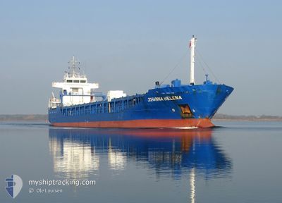
JOHANNA HELENA
General Cargo
Current Trip
| Time Travelled | 18 h, 17 mins |
|---|---|
| Remaining Time | 31 mins |
| Distance Travelled | 200.24 морская миля |
| Remaining Distance | 8.19 морская миля |
| AVG Speed | 11.1 Узлы |
| MAX Speed | 12.2 Узлы |
| AVG Wind | 9.3 knots |
| MAX Wind | 15 knots |
| MIN Temp | 2.1°C / 35.78°F |
| MAX Temp | 6.5°C / 43.7°F |
| Осадка | 4.2 м |
| Позиция Получена | Сейчас |
Current Position
| Долгота | 23.07463° |
|---|---|
| Широта | 59.72742° |
| Статус | Under way using engine |
| Скорость | 10.1 Узлы |
| Курс | 329.9° |
| Район | Gulf of Finland |
| Станция | T-AIS |
| Позиция Получена | Сейчас |
Info
Information
The current position of JOHANNA HELENA is in Gulf of Finland with coordinates 59.72742° / 23.07463° as reported on 2024-04-24 05:34 by AIS to our vessel tracker app. The vessel's current speed is 10.1 Узлы and is heading at the port of HANKO. The estimated time of arrival as calculated by MyShipTracking vessel tracking app is 2024-04-24 06:06 LT
The vessel JOHANNA HELENA (IMO: 9372212, MMSI: 209955000) is a General Cargo that was built in 2009 ( 15 лет ). It's sailing under the flag of [CY] Cyprus.
In this page you can find informations about the vessels current position, last detected port calls, and current voyage information. If the vessels is not in coverage by AIS you will find the latest position.
The current position of JOHANNA HELENA is detected by our AIS receivers and we are not responsible for the reliability of the data. The last position was recorded while the vessel was in Coverage by the Ais receivers of our vessel tracking app.
The current draught of JOHANNA HELENA as reported by AIS is 4.2 meters
Weather
| Temperature | 2.1°C / 35.78°F |
|---|---|
| Wind Speed | 15 knots |
| Direction | 191° S |
| Pressure | 1013.6 hPa |
| Humidity | 85.2 % |
| Cloud Coverage | 37 % |
Featured Company
Last Port Calls
| Port | Arrival | Departure | Time In Port |
|---|---|---|---|
| 2024-04-20 15:13 | 2024-04-23 11:18 | 2 d | |
| 2024-04-17 07:39 | 2024-04-19 20:23 | 2 d | |
| 2024-04-15 21:39 | 2024-04-16 16:52 | 19 h | |
| 2024-04-10 09:34 | 2024-04-11 13:06 | 1 d | |
| 2024-04-08 09:04 | 2024-04-09 10:05 | 1 d | |
| 2024-04-02 14:29 | 2024-04-05 12:21 | 2 d | |
| 2024-03-25 18:19 | 2024-03-26 21:17 | 1 d | |
| 2024-03-21 11:27 | 2024-03-23 07:25 | 1 d | |
| 2024-03-17 22:24 | 2024-03-19 16:23 | 1 d | |
| 2024-03-15 11:12 | 2024-03-16 17:57 | 1 d |
Last Trips
| Origin | Departure | Destination | Arrival | Distance | |
|---|---|---|---|---|---|
| 2024-04-19 23:23 | 2024-04-20 17:13 | 210.25 морская миля | |||
| 2024-04-16 19:52 | 2024-04-17 10:39 | 157.63 морская миля | |||
| 2024-04-11 16:06 | 2024-04-16 00:39 | 495.03 морская миля | |||
| 2024-04-09 12:05 | 2024-04-10 12:34 | 260.50 морская миля | |||
| 2024-04-05 14:21 | 2024-04-08 11:04 | 543.18 морская миля | |||
| 2024-03-26 22:17 | 2024-04-02 16:29 | 999.49 морская миля | |||
| 2024-03-23 09:25 | 2024-03-25 19:19 | 396.39 морская миля | |||
| 2024-03-19 17:23 | 2024-03-21 13:27 | 469.32 морская миля | |||
| 2024-03-16 18:57 | 2024-03-17 23:24 | 301.65 морская миля | |||
| 2024-03-14 07:29 | 2024-03-15 12:12 | 301.53 морская миля |
Events
| Время | Событие | Детали | Позиция / Направление | Информация |
|---|---|---|---|---|
| 2024-04-24 05:13 | Изменение морского района | Finnish part of the Gulf of Finland Finnish part of the Baltic Sea |
59.67777 / 23.03405
Gulf of Finland
FIHKO
|
Скорость: 11.6 kn Курс: 51.6° |
| 2024-04-24 00:01 | Изменение морского района | Finnish part of the Baltic Sea Swedish part of the Baltic Sea |
59.32321 / 21.21301
Baltic Sea
FIHKO
|
Скорость: 11.4 kn Курс: 68.6° |
| 2024-04-24 00:01 | Статус изменился | Under way using engine Default |
59.32321 / 21.21301
FIHKO
|
Скорость: 11.3 kn Курс: 68° |
| 2024-04-24 00:00 | В покрытии |
59.32321 / 21.21301
Baltic Sea
FIHKO
|
Скорость: 11.4 kn Курс: 68.6° |
|
| 2024-04-23 20:52 | Статус изменился | Default Under way using engine |
59.08443 / 20.14767
FIHKO
|
Скорость: 11.2 kn Курс: 65.1° |
| 2024-04-23 20:46 | Вне покрытия |
59.07609 / 20.11290
Baltic Sea
FIHKO
|
Скорость: 11.2 kn Курс: 65.1° |
|
| 2024-04-23 11:55 | Статус изменился | Under way using engine Moored |
58.61269 / 17.31421
FIHKO
|
Скорость: 11.5 kn Курс: 87.7° |
| 2024-04-23 11:18 | ПОРТ ОТПРАВЛЕНИЯ |
|
58.65422 / 17.12336
FIHKO
|
Скорость: 9 kn Курс: 146° |
| 2024-04-23 11:13 | Начало движения |
58.66173 / 17.11104
[SE] OXELOSUND
|
Скорость: 4.7 kn Курс: 138° |
|
| 2024-04-23 11:03 | Статус изменился | Moored Under way using engine |
58.66290 / 17.10996
[SE] OXELOSUND
|
Скорость: Курс: 144° |