
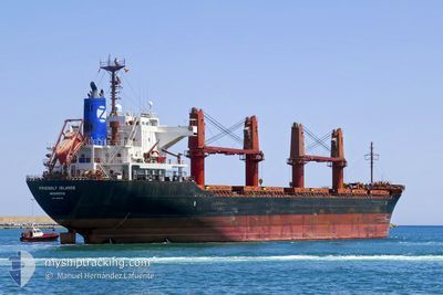
FRIENDLY ISLANDS
Bulk Carrier
Current Trip
ID AMA
| Time Travelled | 34 days |
|---|---|
| Remaining Time | --- |
| Distance Travelled | 7221.36 морская миля |
| Remaining Distance | --- |
| AVG Speed | 11.5 Узлы |
| MAX Speed | 15.6 Узлы |
| AVG Wind | 8.2 knots |
| MAX Wind | 18 knots |
| MIN Temp | 17.2°C / 62.96°F |
| MAX Temp | 31.3°C / 88.34°F |
| Осадка | 5.7 м |
| Позиция Получена | 3 d тому назад |
Current Position
| Долгота | 127.71749° |
|---|---|
| Широта | -2.12857° |
| Статус | Under way using engine |
| Скорость | 13.3 Узлы |
| Курс | 98.9° |
| Район | Ceram Sea |
| Станция | T-AIS |
| Позиция Получена | 3 d тому назад |
Info
Information
The current position of FRIENDLY ISLANDS is in Ceram Sea with coordinates -2.12857° / 127.71749° as reported on 2024-04-21 06:10 by AIS to our vessel tracker app. The vessel's current speed is 13.3 Узлы
The vessel FRIENDLY ISLANDS (IMO: 9615042, MMSI: 636015708) is a Bulk Carrier that was built in 2012 ( 12 лет ). It's sailing under the flag of [LR] Liberia.
In this page you can find informations about the vessels current position, last detected port calls, and current voyage information. If the vessels is not in coverage by AIS you will find the latest position.
The current position of FRIENDLY ISLANDS is detected by our AIS receivers and we are not responsible for the reliability of the data. The last position was recorded while the vessel was in Coverage by the Ais receivers of our vessel tracking app.
The current draught of FRIENDLY ISLANDS as reported by AIS is 5.7 meters
Weather
| Temperature | 29.3°C / 84.74°F |
|---|---|
| Wind Speed | 9 knots |
| Direction | 174° S |
| Pressure | 1006 hPa |
| Humidity | 75.1 % |
| Cloud Coverage | 8 % |
Featured Company
Last Port Calls
| Port | Arrival | Departure | Time In Port |
|---|---|---|---|
| 2024-03-18 02:32 | 2024-03-21 01:24 | 2 d | |
| 2024-02-15 01:50 | 2024-02-20 00:26 | 4 d | |
| 2024-02-01 00:37 | 2024-02-03 23:24 | 2 d |
Events
| Время | Событие | Детали | Позиция / Направление | Информация |
|---|---|---|---|---|
| 2024-04-23 23:02 | Окончание движения |
-4.99697 / 136.62460
ID AMA
|
Скорость: 0.2 kn Курс: 67° |
|
| 2024-04-23 02:39 | Окончание движения |
-4.99522 / 136.62650
ID AMA
|
Скорость: 0.3 kn Курс: 155° |
|
| 2024-04-21 06:25 | Статус изменился | Default Under way using engine |
-2.13835 / 127.77126
ID AMA
|
Скорость: 13.3 kn Курс: 98.9° |
| 2024-04-21 06:10 | Вне покрытия |
-2.12857 / 127.71749
Ceram Sea
ID AMA
|
Скорость: 13.3 kn Курс: 98.9° |
|
| 2024-04-21 06:08 | Статус изменился | Under way using engine Default |
-2.12738 / 127.71022
ID AMA
|
Скорость: 13.3 kn Курс: 99° |
| 2024-04-21 05:50 | В покрытии |
-2.12738 / 127.71022
Ceram Sea
ID AMA
|
Скорость: 13.3 kn Курс: 99.6° |
|
| 2024-04-21 05:00 | Статус изменился | Default Under way using engine |
-2.08833 / 127.46136
ID AMA
|
Скорость: 13.5 kn Курс: 97.9° |
| 2024-04-21 04:57 | Вне покрытия |
-2.08649 / 127.44823
Ceram Sea
ID AMA
|
Скорость: 13.5 kn Курс: 97.9° |
|
| 2024-04-21 04:36 | Статус изменился | Under way using engine Default |
-2.04670 / 127.38738
ID AMA
|
Скорость: 12.6 kn Курс: 138° |
| 2024-04-21 04:23 | В покрытии |
-2.04811 / 127.38865
Ceram Sea
ID AMA
|
Скорость: 12.7 kn Курс: 138.4° |