
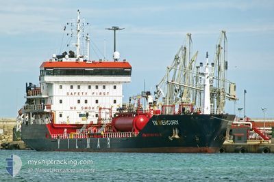
YM MERCURY
Oil/Chemical Tanker
Current Trip
| Time Travelled | 3 days |
|---|---|
| Remaining Time | --- |
| Distance Travelled | 833.85 nm |
| Remaining Distance | --- |
| AVG Speed | 11.4 Knopen |
| MAX Speed | 13.2 Knopen |
| AVG Wind | 7.5 knots |
| MAX Wind | 24.5 knots |
| MIN Temp | 10.8°C / 51.44°F |
| MAX Temp | 16°C / 60.8°F |
| Diepgang | 5.2 M |
| Positie ontvangen | 1 m geleden |
Current Position
| Lengtegraad | --- |
|---|---|
| Breedtegraat | --- |
| Status | Under way using engine |
| Snelheid | 12.1 Knopen |
| Koers | 261.9° |
| Gebied | Mediterranean Sea - Western Basin |
| Station | T-AIS |
| Positie ontvangen | 1 m geleden |
Info
Information
The current position of YM MERCURY is in Mediterranean Sea - Western Basin with coordinates 36.64105° / -0.70933° as reported on 2025-02-27 00:23 by AIS to our vessel tracker app. The vessel's current speed is 12.1 Knopen and is heading at the port of MOHAMMEDIA. The estimated time of arrival as calculated by MyShipTracking vessel tracking app is 2025-02-28 13:00 LT
The vessel YM MERCURY (IMO: 9452775, MMSI: 248507000) is a Oil/Chemical Tanker that was built in 2010 ( 15 Jaar oud ). It's sailing under the flag of [MT] Malta.
In this page you can find informations about the vessels current position, last detected port calls, and current voyage information. If the vessels is not in coverage by AIS you will find the latest position.
The current position of YM MERCURY is detected by our AIS receivers and we are not responsible for the reliability of the data. The last position was recorded while the vessel was in Coverage by the Ais receivers of our vessel tracking app.
The current draught of YM MERCURY as reported by AIS is 5.2 meters
Weather
| Temperature | 15°C / 59°F |
|---|---|
| Wind Speed | 8 knots |
| Direction | 130° SE |
| Pressure | 1022.8 hPa |
| Humidity | 64 % |
| Cloud Coverage | 94 % |
Featured Company
Last Port Calls
| Port | Arrival | Departure | Time In Port |
|---|---|---|---|
| 2025-02-22 13:25 | 2025-02-23 23:29 | 1 d | |
| 2025-02-17 08:42 | 2025-02-19 01:57 | 1 d | |
| 2025-02-12 14:21 | 2025-02-13 17:29 | 1 d | |
| 2025-02-08 21:13 | 2025-02-09 13:23 | 16 h | |
| 2025-02-04 07:19 | 2025-02-05 16:06 | 1 d | |
| 2025-02-01 17:22 | 2025-02-01 23:35 | 6 h | |
| 2025-01-25 18:17 | 2025-01-26 06:37 | 12 h | |
| 2025-01-19 17:05 | 2025-01-21 08:12 | 1 d | |
| 2025-01-13 08:53 | 2025-01-15 12:41 | 2 d | |
| 2025-01-08 18:09 | 2025-01-09 13:41 | 19 h |
Last Trips
| Origin | Departure | Destination | Arrival | Distance | |
|---|---|---|---|---|---|
| 2025-02-19 01:57 | 2025-02-22 13:25 | 840.14 nm | |||
| 2025-02-13 17:29 | 2025-02-17 08:42 | 816.57 nm | |||
| 2025-02-09 13:23 | 2025-02-12 14:21 | 822.52 nm | |||
| 2025-02-05 16:06 | 2025-02-08 21:13 | 910.13 nm | |||
| 2025-02-01 23:35 | 2025-02-04 07:19 | 473.98 nm | |||
| 2025-01-26 06:37 | 2025-02-01 17:22 | 1654.81 nm | |||
| 2025-01-21 08:12 | 2025-01-25 18:17 | 490.42 nm | |||
| 2025-01-15 12:41 | 2025-01-19 17:05 | 342.78 nm | |||
| 2025-01-09 13:41 | 2025-01-13 08:53 | 818.94 nm | |||
| 2025-01-05 22:00 | 2025-01-08 18:09 | 823.63 nm |
Events
| Tijd | Evenement | Details | Positie / Bestemming | Info |
|---|---|---|---|---|
| 2025-02-26 23:51 | Status Changed | Under way using engine Default |
36.65712 / -.57410
ITAUG>MAMOH
|
Snelheid: 12.3 kn Koers: 260° |
| 2025-02-26 23:38 | Status Changed | Default Under way using engine |
36.66486 / -.51972
ITAUG>MAMOH
|
Snelheid: 12.2 kn Koers: 261.7° |
| 2025-02-26 23:25 | Status Changed | Under way using engine Default |
36.67177 / -.46532
ITAUG>MAMOH
|
Snelheid: 12.1 kn Koers: 262° |
| 2025-02-26 23:16 | Status Changed | Default Under way using engine |
36.67622 / -.42615
ITAUG>MAMOH
|
Snelheid: 12.1 kn Koers: 261.4° |
| 2025-02-26 23:04 | Draught Changed | 5.2 5.1 |
36.68213 / -.37629
ITAUG>MAMOH
|
Snelheid: 12.2 kn Koers: 264.7° |
| 2025-02-26 23:04 | Destination Changed | ITAUG>MAMOH TRGEM>ITAUG |
36.68213 / -.37629
ITAUG>MAMOH
|
Snelheid: 12.2 kn Koers: 264.7° |
| 2025-02-26 23:04 | ETA Changed | 2025/02/28 13:00 2025/02/22 20:00 |
36.68213 / -.37629
ITAUG>MAMOH
|
Snelheid: 12.2 kn Koers: 264.7° |
| 2025-02-26 22:38 | Status Changed | Under way using engine Default |
36.69086 / -.27024
TRGEM>ITAUG
|
Snelheid: 12.2 kn Koers: 266° |
| 2025-02-26 22:28 | Status Changed | Default Under way using engine |
36.69397 / -.23047
TRGEM>ITAUG
|
Snelheid: 12 kn Koers: 266.1° |
| 2025-02-26 22:19 | Wijzig zee gebeid | Algerian part of the Mediterranean Sea - Western Basin Italian part of the Ionian Sea |
36.69666 / -.19044
Mediterranean Sea - Western Basin
|
Snelheid: 12 kn Koers: 266.1° |