
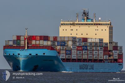
VENTA MAERSK
Cargo A
Current Trip
| Time Travelled | 7 days |
|---|---|
| Remaining Time | 2 days |
| Distance Travelled | 1674.02 nm |
| Remaining Distance | 817.55 nm |
| AVG Speed | 16.2 Knopen |
| MAX Speed | 20.5 Knopen |
| AVG Wind | 20.9 knots |
| MAX Wind | 33.1 knots |
| MIN Temp | -2.2°C / 28.04°F |
| MAX Temp | 13.9°C / 57.02°F |
| Diepgang | 11.9 M |
| Positie ontvangen | 5 h, 16 m geleden |
Current Position
| Lengtegraad | 21.65142° |
|---|---|
| Breedtegraat | 59.16322° |
| Status | Under way using engine |
| Snelheid | 15.7 Knopen |
| Koers | 228.6° |
| Gebied | Baltic Sea |
| Station | T-AIS |
| Positie ontvangen | 5 h, 16 m geleden |
Info
Information
The current position of VENTA MAERSK is in Baltic Sea with coordinates 59.16322° / 21.65142° as reported on 2024-04-20 07:50 by AIS to our vessel tracker app. The vessel's current speed is 15.7 Knopen and is heading at the port of BREMERHAVEN. The estimated time of arrival as calculated by MyShipTracking vessel tracking app is 2024-04-22 15:46 LT
The vessel VENTA MAERSK (IMO: 9775763, MMSI: 219115000) is a Cargo A It's sailing under the flag of [DK] Denmark.
In this page you can find informations about the vessels current position, last detected port calls, and current voyage information. If the vessels is not in coverage by AIS you will find the latest position.
The current position of VENTA MAERSK is detected by our AIS receivers and we are not responsible for the reliability of the data. The last position was recorded while the vessel was in Coverage by the Ais receivers of our vessel tracking app.
The current draught of VENTA MAERSK as reported by AIS is 11.9 meters
Weather
| Temperature | 1.2°C / 34.16°F |
|---|---|
| Wind Speed | 18 knots |
| Direction | 340° NNW |
| Pressure | 1012.7 hPa |
| Humidity | 81.7 % |
| Cloud Coverage | 100 % |
Featured Company
Last Port Calls
| Port | Arrival | Departure | Time In Port |
|---|---|---|---|
| 2024-04-10 22:16 | 2024-04-12 18:54 | 1 d | |
| 2024-04-08 14:35 | 2024-04-09 07:25 | 16 h | |
| 2024-04-06 08:30 | 2024-04-07 12:18 | 1 d | |
| 2024-04-02 05:45 | 2024-04-03 06:53 | 1 d | |
| 2024-03-31 13:30 | 2024-04-01 16:58 | 1 d | |
| 2024-03-28 12:48 | 2024-03-28 20:17 | 7 h | |
| 2024-03-24 10:09 | 2024-03-26 18:46 | 2 d | |
| 2024-03-19 16:55 | 2024-03-20 14:24 | 21 h | |
| 2024-03-15 03:14 | 2024-03-16 05:12 | 1 d | |
| 2024-03-10 03:19 | 2024-03-10 16:43 | 13 h |
Most Visited Ports (Last year)
| Port | Arrivals | |
|---|---|---|
| 17 | ||
| 13 | ||
| 9 | ||
| 8 | ||
| 7 | ||
| 6 |
Last Trips
| Origin | Departure | Destination | Arrival | Distance | |
|---|---|---|---|---|---|
| 2024-04-09 09:25 | 2024-04-10 23:16 | 125.20 nm | |||
| 2024-04-07 14:18 | 2024-04-08 16:35 | 288.58 nm | |||
| 2024-04-03 08:53 | 2024-04-06 10:30 | 907.08 nm | |||
| 2024-04-01 19:58 | 2024-04-02 07:45 | 172.71 nm | |||
| 2024-03-28 21:17 | 2024-03-31 16:30 | 996.14 nm | |||
| 2024-03-26 19:46 | 2024-03-28 13:48 | 124.34 nm | |||
| 2024-03-20 15:24 | 2024-03-24 11:09 | 397.67 nm | |||
| 2024-03-16 07:12 | 2024-03-19 17:55 | 605.88 nm | |||
| 2024-03-10 18:43 | 2024-03-15 05:14 | 575.84 nm | |||
| 2024-03-08 20:08 | 2024-03-10 05:19 | 352.41 nm |
Events
| Tijd | Evenement | Details | Positie / Bestemming | Info |
|---|---|---|---|---|
| 2024-04-20 07:53 | Status Changed | Default Under way using engine |
59.15277 / 21.63158
FIKTK - DEBRV
|
Snelheid: 15.7 kn Koers: 228.6° |
| 2024-04-20 07:50 | Buitenbereik |
59.16322 / 21.65142
Baltic Sea
FIKTK - DEBRV
|
Snelheid: 15.7 kn Koers: 228.6° |
|
| 2024-04-20 06:47 | Gevonden in zee | Estonian part of the Baltic Sea |
59.32020 / 22.09163
Baltic Sea
FIKTK - DEBRV
|
Snelheid: 15.6 kn Koers: 234.7° |
| 2024-04-20 04:35 | Wijzig zee gebeid | Finnish part of the Baltic Sea Finnish part of the Gulf of Finland |
59.57570 / 23.09915
Baltic Sea
FIKTK - DEBRV
|
Snelheid: 15.9 kn Koers: 253.9° |
| 2024-04-20 01:20 | Gevonden in zee | Finnish part of the Gulf of Finland |
59.81862 / 24.71602
Gulf of Finland
FIKTK - DEBRV
|
Snelheid: 15.9 kn Koers: 256.8° |
| 2024-04-20 00:02 | Wijzig zee gebeid | Estonian part of the Gulf of Finland Finnish part of the Gulf of Finland |
59.87903 / 25.38623
Gulf of Finland
FIKTK - DEBRV
|
Snelheid: 15.8 kn Koers: 265.2° |
| 2024-04-19 19:54 | Start beweging | 3.84 nm, South of KOTKA |
60.41792 / 26.91902
FIKTK - DEBRV
|
Snelheid: 3.2 kn Koers: 228° |
| 2024-04-19 19:51 | Status Changed | Under way using engine Moored |
60.41827 / 26.91945
FIKTK - DEBRV
|
Snelheid: 1.7 kn Koers: 293° |
| 2024-04-19 19:08 | Status Changed | Moored Default |
60.41855 / 26.91445
FIKTK - DEBRV
|
Snelheid: Koers: 320° |
| 2024-04-19 19:01 | Status Changed | Default Moored |
60.41855 / 26.91445
FIKTK - DEBRV
|
Snelheid: Koers: 320° |