img
No Internet
SWIPE TO GO BACK
TRIP
POSITION
INFO
PORT CALLS
VISITED PORTS
LAST TRIPS
EVENTS
WEATHER
image
Upload Photo
Type
IMO ---
MMSI 244750164
Vlag
Flag Netherlands
Call Sign PB4643
Grote 17 x 6 M
GT ---
DWT ---
Bouw ---
Status Active
Eigenaar

Current Trip

Flag NLTSL
ATD
2025-04-18 16:26 (UTC)
Flag NLHAR
ATA
2025-05-11 14:14 (UTC)
7 days ago
Trip Time 22 days
Trip Distance 22.93 nm
AVG Speed 17.3 Knopen
MAX Speed 21.4 Knopen
Diepgang ---
AVG Wind 8 knots
MAX Wind 8.8 knots
MIN Temp 8.9°C / 48.02°F
MAX Temp 17.9°C / 64.22°F
Positie ontvangen 7 d geleden

Current Position

Lengtegraad ---
Breedtegraat ---
Status Default
Snelheid
Koers ---
Gebied North Sea
Station T-AIS
Positie ontvangen 7 d geleden

Info

info

Information

The current position of SEATENDER is in North Sea with coordinates 53.17228° / 5.41640° as reported on 2025-05-11 14:21 by AIS to our vessel tracker app. The vessel's current speed is 0 Knopen and is currently inside the port of HARLINGEN.

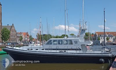
The vessel SEATENDER (MMSI: 244750164) is a Pleasure Craft It's sailing under the flag of [NL] Netherlands.

In this page you can find informations about the vessels current position, last detected port calls, and current voyage information. If the vessels is not in coverage by AIS you will find the latest position.

The current position of SEATENDER is detected by our AIS receivers and we are not responsible for the reliability of the data. The last position was recorded while the vessel was in Coverage by the Ais receivers of our vessel tracking app.

Weather

Temperature 17.9°C / 64.22°F
Wind Speed 8 knots
Direction 95° E
Pressure 1014.6 hPa
Humidity 63.3 %
Cloud Coverage 7 %

Featured Company

Last Port Calls

Port Arrival Departure Time In Port
Flag HARLINGEN 2025-05-11 14:14
Flag TERSCHELLING 2025-04-18 11:37 2025-04-18 16:26 4 h
Flag HARLINGEN 2025-03-31 16:48 2025-04-11 09:06 10 d
Flag TERSCHELLING 2025-03-31 13:08 2025-03-31 15:49 2 h
Flag HARLINGEN 2025-03-30 14:51 2025-03-31 12:15 21 h
Flag VLIELAND 2025-03-15 13:43 2025-03-30 13:51 15 d
Flag TERSCHELLING 2025-03-15 11:25 2025-03-15 13:23 1 h
Flag VLIELAND 2025-03-14 14:56 2025-03-15 11:00 20 h
Flag HARLINGEN 2025-03-02 11:36 2025-03-14 14:10 12 d
Flag VLIELAND 2025-03-01 09:51 2025-03-02 10:47 1 d
Show More

Most Visited Ports (Last year)

Port Arrivals
Flag HARLINGEN 13
Flag VLIELAND 10
Flag TERSCHELLING 7

Last Trips

Origin Departure Destination Arrival Distance
Flag TERSCHELLING 2025-04-18 18:26 Flag HARLINGEN 2025-05-11 16:14 22.93 nm
Flag HARLINGEN 2025-04-11 11:06 Flag TERSCHELLING 2025-04-18 13:37 21.73 nm
Flag TERSCHELLING 2025-03-31 17:49 Flag HARLINGEN 2025-03-31 18:48 19.22 nm
Flag HARLINGEN 2025-03-31 14:15 Flag TERSCHELLING 2025-03-31 15:08 19.08 nm
Flag VLIELAND 2025-03-30 15:51 Flag HARLINGEN 2025-03-30 16:51 16.20 nm
Flag TERSCHELLING 2025-03-15 14:23 Flag VLIELAND 2025-03-15 14:43 5.96 nm
Flag VLIELAND 2025-03-15 12:00 Flag TERSCHELLING 2025-03-15 12:25 6.25 nm
Flag HARLINGEN 2025-03-14 15:10 Flag VLIELAND 2025-03-14 15:56 16.41 nm
Flag VLIELAND 2025-03-02 11:47 Flag HARLINGEN 2025-03-02 12:36 16.68 nm
Flag HARLINGEN 2025-03-01 10:01 Flag VLIELAND 2025-03-01 10:51 17.08 nm

Events

Tijd Evenement Details Positie / Bestemming Info
2025-05-11 14:21 Buitenbereik
53.17228 / 5.41640
North Sea
[NL] HARLINGEN
Snelheid:
Koers: 134.8°
2025-05-11 14:15 Stop beweging Flag HARLINGEN
53.17229 / 5.41639
[NL] HARLINGEN
Snelheid:
Koers: 511°
2025-05-11 14:14 Aankomsthaven Flag HARLINGEN
53.17229 / 5.41639
[NL] HARLINGEN
Snelheid: 1.5 kn
Koers: 511°
2025-05-11 13:11 Binnenbereik
53.31457 / 5.12545
North Sea
Snelheid: 19.5 kn
Koers: 79°
Show More