
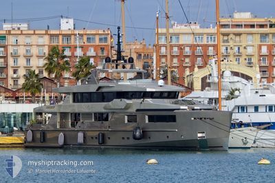
MAVERICK
Pleasure Craft
Current Trip
FLL
| Trip Time | --- |
|---|---|
| Trip Distance | --- |
| AVG Speed | --- |
| MAX Speed | --- |
| Diepgang | --- |
| AVG Wind | --- |
| MAX Wind | --- |
| MIN Temp | --- |
| MAX Temp | --- |
| Positie ontvangen | 19 h, 31 m geleden |
Current Position
| Lengtegraad | --- |
|---|---|
| Breedtegraat | --- |
| Status | Moored |
| Snelheid | |
| Koers | 90° |
| Gebied | Balearic Sea |
| Station | T-AIS |
| Positie ontvangen | 19 h, 31 m geleden |
Info
Information
The current position of MAVERICK is in Balearic Sea with coordinates 26.09791° / -80.16305° as reported on 2024-09-28 21:50 by AIS to our vessel tracker app. The vessel's current speed is 0 Knopen and is currently inside the port of FORT LAUDERDALE.
The vessel MAVERICK (IMO: 9707209, MMSI: 538071238) is a Pleasure Craft It's sailing under the flag of [MH] Marshall Is.
In this page you can find informations about the vessels current position, last detected port calls, and current voyage information. If the vessels is not in coverage by AIS you will find the latest position.
The current position of MAVERICK is detected by our AIS receivers and we are not responsible for the reliability of the data. The last position was recorded while the vessel was in Coverage by the Ais receivers of our vessel tracking app.
The current draught of MAVERICK as reported by AIS is 2.4 meters
Weather
| Temperature | 34.1°C / 93.38°F |
|---|---|
| Wind Speed | 11 knots |
| Direction | 178° S |
| Pressure | 1011.1 hPa |
| Humidity | 46.9 % |
| Cloud Coverage | 97 % |
Featured Company
Last Port Calls
| Port | Arrival | Departure | Time In Port |
|---|---|---|---|
| 2024-09-21 20:22 | |||
| 2024-09-02 07:00 | |||
| 2024-08-25 05:55 | 2024-09-02 06:32 | 8 d | |
| 2024-08-20 14:19 | 2024-08-22 05:14 | 1 d | |
| 2024-08-17 07:46 | 2024-08-17 23:05 | 15 h | |
| 2024-08-16 05:59 | 2024-08-16 20:53 | 14 h | |
| 2024-08-15 13:55 | 2024-08-15 22:47 | 8 h | |
| 2024-08-10 16:27 | 2024-08-12 13:46 | 1 d | |
| 2024-08-09 15:11 | 2024-08-10 09:28 | 18 h | |
| 2024-08-01 10:11 | 2024-08-03 10:48 | 2 d |
Most Visited Ports (Last year)
| Port | Arrivals | |
|---|---|---|
| 5 | ||
| 5 | ||
| 5 | ||
| 5 | ||
| 3 | ||
| 2 |
Last Trips
| Origin | Departure | Destination | Arrival | Distance | |
|---|---|---|---|---|---|
| 2024-09-02 08:32 | 2024-09-02 09:00 | 0.72 nm | |||
| 2024-08-22 07:14 | 2024-08-25 07:55 | 603.13 nm | |||
| 2024-08-18 01:05 | 2024-08-20 16:19 | 129.25 nm | |||
| 2024-08-16 22:53 | 2024-08-17 09:46 | 113.06 nm | |||
| 2024-08-16 00:47 | 2024-08-16 07:59 | 79.56 nm | |||
| 2024-08-12 15:46 | 2024-08-15 15:55 | 82.24 nm | |||
| 2024-08-10 11:28 | 2024-08-10 18:27 | 82.00 nm | |||
| 2024-08-03 12:48 | 2024-08-09 17:11 | 199.83 nm | |||
| 2024-07-23 12:07 | 2024-08-01 12:11 | 463.75 nm | |||
| 2024-07-12 12:49 | 2024-07-21 13:40 | 326.87 nm |
Events
| Tijd | Evenement | Details | Positie / Bestemming | Info |
|---|---|---|---|---|
| 2024-09-28 21:50 | Buitenbereik |
26.09791 / -80.16305
Balearic Sea
[US] FORT LAUDERDALE
|
Snelheid: Koers: 256.7° |
|
| 2024-09-27 19:35 | Binnenbereik |
26.09784 / -80.16312
Balearic Sea
[US] FORT LAUDERDALE
|
Snelheid: Koers: 182.7° |
|
| 2024-09-27 15:57 | Buitenbereik |
26.09912 / -80.16247
Balearic Sea
[US] FORT LAUDERDALE
|
Snelheid: 0.2 kn Koers: 94.8° |
|
| 2024-09-22 19:53 | Destination Changed | FLL PALMA |
26.09789 / -80.16775
[US] FORT LAUDERDALE
|
Snelheid: Koers: 217° |
| 2024-09-22 14:39 | Status Changed | Moored Not under command |
26.09787 / -80.16774
[US] FORT LAUDERDALE
|
Snelheid: Koers: 217° |
| 2024-09-22 14:21 | Stop beweging |
26.09802 / -80.16759
[US] FORT LAUDERDALE
|
Snelheid: 0.2 kn Koers: 227° |
|
| 2024-09-22 13:11 | Status Changed | Not under command Moored |
26.11052 / -80.11988
[US] FORT LAUDERDALE
|
Snelheid: 4.4 kn Koers: 194° |
| 2024-09-22 13:05 | Start beweging |
26.10331 / -80.11923
[US] FORT LAUDERDALE
|
Snelheid: 4.2 kn Koers: 158° |
|
| 2024-09-21 20:22 | Stop beweging |
26.10161 / -80.11833
[US] FORT LAUDERDALE
|
Snelheid: 0.3 kn Koers: 165° |
|
| 2024-09-21 20:22 | Aankomsthaven |
|
26.10161 / -80.11833
[US] FORT LAUDERDALE
|
Snelheid: 0.6 kn Koers: 168° |