
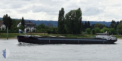
LINNEA
Cargo
Current Trip
| Time Travelled | 1 day |
|---|---|
| Remaining Time | --- |
| Distance Travelled | 14.15 nm |
| Remaining Distance | --- |
| AVG Speed | 5.3 Knopen |
| MAX Speed | 7.3 Knopen |
| AVG Wind | 9.3 knots |
| MAX Wind | 10 knots |
| MIN Temp | 11.2°C / 52.16°F |
| MAX Temp | 11.6°C / 52.88°F |
| Diepgang | 3 M |
| Positie ontvangen | 19 h, 2 m geleden |
Current Position
| Lengtegraad | --- |
|---|---|
| Breedtegraat | --- |
| Status | Under way using engine |
| Snelheid | 4.1 Knopen |
| Koers | 210.2° |
| Gebied | North Sea |
| Station | T-AIS |
| Positie ontvangen | 19 h, 2 m geleden |
Info
Information
The current position of LINNEA is in North Sea with coordinates 49.76453° / 6.63154° as reported on 2025-12-08 18:25 by AIS to our vessel tracker app. The vessel's current speed is 4.1 Knopen and is heading at the port of HANSWEERT. The estimated time of arrival as calculated by MyShipTracking vessel tracking app is 2025-12-09 12:16 LT
The vessel LINNEA (MMSI: 244700965) is a Cargo It's sailing under the flag of [NL] Netherlands.
In this page you can find informations about the vessels current position, last detected port calls, and current voyage information. If the vessels is not in coverage by AIS you will find the latest position.
The current position of LINNEA is detected by our AIS receivers and we are not responsible for the reliability of the data. The last position was recorded while the vessel was in Coverage by the Ais receivers of our vessel tracking app.
The current draught of LINNEA as reported by AIS is 3 meters
Weather
| Temperature | 11.3°C / 52.34°F |
|---|---|
| Wind Speed | 7 knots |
| Direction | 181° S |
| Pressure | 1014.8 hPa |
| Humidity | 84.2 % |
| Cloud Coverage | 100 % |
Featured Company
Last Port Calls
| Port | Arrival | Departure | Time In Port |
|---|---|---|---|
| 2025-12-08 12:09 | 2025-12-08 13:08 | 59 m | |
| 2025-12-05 11:39 | 2025-12-05 12:25 | 46 m | |
| 2025-12-04 10:52 | 2025-12-04 22:19 | 11 h | |
| 2025-12-03 01:04 | 2025-12-04 08:35 | 1 d | |
| 2025-12-01 15:27 | 2025-12-02 16:30 | 1 d | |
| 2025-11-30 20:13 | 2025-12-01 05:10 | 8 h | |
| 2025-11-28 15:13 | 2025-11-30 12:11 | 1 d | |
| 2025-11-27 23:16 | 2025-11-28 14:54 | 15 h | |
| 2025-11-27 22:26 | 2025-11-27 22:49 | 22 m | |
| 2025-11-27 21:25 | 2025-11-27 22:00 | 35 m |
Most Visited Ports (Last year)
| Port | Arrivals | |
|---|---|---|
| 13 | ||
| 12 | ||
| 10 | ||
| 10 | ||
| 8 | ||
| 8 |
Last Trips
| Origin | Departure | Destination | Arrival | Distance | |
|---|---|---|---|---|---|
| 2025-12-05 12:25 | 2025-12-08 12:09 | 182.45 nm | |||
| 2025-12-04 22:19 | 2025-12-05 11:39 | 84.46 nm | |||
| 2025-12-04 08:35 | 2025-12-04 10:52 | 22.82 nm | |||
| 2025-12-02 16:30 | 2025-12-03 01:04 | 103.62 nm | |||
| 2025-12-01 05:10 | 2025-12-01 15:27 | 59.43 nm | |||
| 2025-11-30 12:11 | 2025-11-30 20:13 | 62.69 nm | |||
| 2025-11-28 14:54 | 2025-11-28 15:13 | 2.84 nm | |||
| 2025-11-27 22:49 | 2025-11-27 23:16 | 2.42 nm | |||
| 2025-11-27 22:00 | 2025-11-27 22:26 | 4.62 nm | |||
| 2025-11-27 11:09 | 2025-11-27 21:25 | 50.12 nm |
Events
| Tijd | Evenement | Details | Positie / Bestemming | Info |
|---|---|---|---|---|
| 2025-12-09 08:09 | Start beweging | 5.8 nm, South East of MERTERT |
49.61833 / 6.56167
DILLINGEN
|
Snelheid: 4 kn Koers: -1° |
| 2025-12-08 18:25 | Buitenbereik |
49.76453 / 6.63154
North Sea
DILLINGEN
|
Snelheid: 4.1 kn Koers: 210.2° |
|
| 2025-12-08 16:28 | Binnenbereik |
49.79319 / 6.82428
North Sea
DILLINGEN
|
Snelheid: 7 kn Koers: 239.3° |
|
| 2025-12-08 12:08 | Vertrekhaven |
|
49.82500 / 6.90333
DILLINGEN
|
Snelheid: 6 kn Koers: 161° |
| 2025-12-08 11:09 | Aankomsthaven |
|
49.92333 / 7.06667
[DE] BERNKASTEL
|
Snelheid: 6 kn Koers: 120° |
| 2025-12-08 10:54 | Start beweging | 2.13 nm, North West of BERNKASTEL |
49.94333 / 7.04333
DILLINGEN
|
Snelheid: 6 kn Koers: 120° |
| 2025-12-08 08:57 | Stop beweging | 2.66 nm, North West of BERNKASTEL |
49.94667 / 7.02667
DILLINGEN
|
Snelheid: Koers: -1° |
| 2025-12-06 11:00 | Buitenbereik |
50.51537 / 7.29974
North Sea
DILLINGEN
|
Snelheid: 4.9 kn Koers: 161.7° |
|
| 2025-12-06 09:52 | Status Changed | Under way using engine Default |
50.59740 / 7.21087
DILLINGEN
|
Snelheid: 4 kn Koers: -1° |
| 2025-12-06 09:12 | Status Changed | Default Under way using engine |
50.65667 / 7.20167
DILLINGEN
|
Snelheid: 5.7 kn Koers: 153° |