
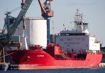
KILSTRAUM
Oil/Chemical Tanker
Current Trip
| Time Travelled | 2 days |
|---|---|
| Remaining Time | --- |
| Distance Travelled | 525.09 nm |
| Remaining Distance | --- |
| AVG Speed | 9.6 Knopen |
| MAX Speed | 14.5 Knopen |
| AVG Wind | 18.6 knots |
| MAX Wind | 27.9 knots |
| MIN Temp | 5.8°C / 42.44°F |
| MAX Temp | 10°C / 50°F |
| Diepgang | 6.4 M |
| Positie ontvangen | Nu |
Current Position
| Lengtegraad | 7.78514° |
|---|---|
| Breedtegraat | 56.96306° |
| Status | Under way using engine |
| Snelheid | 13 Knopen |
| Koers | 32.6° |
| Gebied | North Sea |
| Station | T-AIS |
| Positie ontvangen | Nu |
Info
Information
The current position of KILSTRAUM is in North Sea with coordinates 56.96306° / 7.78514° as reported on 2024-04-23 11:46 by AIS to our vessel tracker app. The vessel's current speed is 13 Knopen and is heading at the port of PORSGRUNN. The estimated time of arrival as calculated by MyShipTracking vessel tracking app is 2024-04-23 23:00 LT
The vessel KILSTRAUM (IMO: 9164732, MMSI: 257643000) is a Oil/Chemical Tanker that was built in 1999 ( 25 Jaar oud ). It's sailing under the flag of [NO] Norway.
In this page you can find informations about the vessels current position, last detected port calls, and current voyage information. If the vessels is not in coverage by AIS you will find the latest position.
The current position of KILSTRAUM is detected by our AIS receivers and we are not responsible for the reliability of the data. The last position was recorded while the vessel was in Coverage by the Ais receivers of our vessel tracking app.
The current draught of KILSTRAUM as reported by AIS is 6.4 meters
Weather
| Temperature | 6°C / 42.8°F |
|---|---|
| Wind Speed | 17 knots |
| Direction | 320° NW |
| Pressure | 1011.4 hPa |
| Humidity | 70.7 % |
| Cloud Coverage | 78 % |
Featured Company
Last Port Calls
| Port | Arrival | Departure | Time In Port |
|---|---|---|---|
| 2024-04-19 13:03 | 2024-04-20 14:04 | 1 d | |
| 2024-04-17 23:12 | 2024-04-18 20:51 | 21 h | |
| 2024-04-17 19:40 | 2024-04-17 21:16 | 1 h | |
| 2024-04-16 15:49 | 2024-04-17 19:08 | 1 d | |
| 2024-04-14 05:55 | 2024-04-14 06:53 | 57 m | |
| 2024-04-12 20:58 | 2024-04-13 12:14 | 15 h | |
| 2024-04-10 19:33 | 2024-04-12 00:32 | 1 d | |
| 2024-04-07 15:39 | 2024-04-07 23:00 | 7 h | |
| 2024-04-06 06:18 | 2024-04-06 15:14 | 8 h | |
| 2024-04-05 23:12 | 2024-04-06 03:10 | 3 h |
Last Trips
| Origin | Departure | Destination | Arrival | Distance | |
|---|---|---|---|---|---|
| 2024-04-18 22:51 | 2024-04-19 14:03 | 173.99 nm | |||
| 2024-04-17 23:16 | 2024-04-18 01:12 | 23.17 nm | |||
| 2024-04-17 21:08 | 2024-04-17 21:40 | 1.90 nm | |||
| 2024-04-14 08:53 | 2024-04-16 17:49 | 394.96 nm | |||
| 2024-04-13 14:14 | 2024-04-14 07:55 | 196.48 nm | |||
| 2024-04-12 02:32 | 2024-04-12 22:58 | 238.97 nm | |||
| 2024-04-08 01:00 | 2024-04-10 21:33 | 687.17 nm | |||
| 2024-04-06 17:14 | 2024-04-07 17:39 | 235.03 nm | |||
| 2024-04-06 05:10 | 2024-04-06 08:18 | 37.58 nm | |||
| 2024-04-05 16:09 | 2024-04-06 01:12 | 110.74 nm |
Events
| Tijd | Evenement | Details | Positie / Bestemming | Info |
|---|---|---|---|---|
| 2024-04-23 08:06 | Gevonden in zee | Danish part of the North Sea |
56.34324 / 6.99249
North Sea
NO HRY
|
Snelheid: 12.5 kn Koers: 42.1° |
| 2024-04-23 08:06 | Status Changed | Under way using engine Default |
56.34324 / 6.99249
NO HRY
|
Snelheid: 12.3 kn Koers: 41° |
| 2024-04-23 07:54 | Binnenbereik |
56.34324 / 6.99249
North Sea
NO HRY
|
Snelheid: 12.5 kn Koers: 42.1° |
|
| 2024-04-22 17:16 | Status Changed | Default Under way using engine |
53.54253 / 4.78440
NO HRY
|
Snelheid: 12.7 kn Koers: 21.1° |
| 2024-04-22 17:16 | Buitenbereik |
53.54082 / 4.78324
North Sea
NO HRY
|
Snelheid: 12.7 kn Koers: 21.1° |
|
| 2024-04-22 17:09 | ETA Changed | 2024/04/23 23:00 2024/04/24 00:30 |
53.51823 / 4.76779
NO HRY
|
Snelheid: 12.5 kn Koers: 22.2° |
| 2024-04-22 17:03 | Status Changed | Under way using engine Default |
53.49790 / 4.75364
NO HRY
|
Snelheid: 12.7 kn Koers: 21° |
| 2024-04-22 16:45 | Status Changed | Default Under way using engine |
53.43970 / 4.71629
NO HRY
|
Snelheid: 12.6 kn Koers: 23.3° |
| 2024-04-22 15:55 | Status Changed | Under way using engine Default |
53.27705 / 4.59923
NO HRY
|
Snelheid: 12.8 kn Koers: 23° |
| 2024-04-22 15:08 | Status Changed | Default Under way using engine |
53.12546 / 4.46748
NO HRY
|
Snelheid: 13.5 kn Koers: 31.3° |