
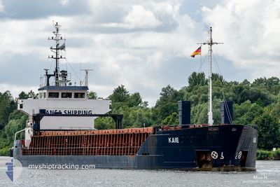
KAIE
General Cargo
Current Trip
| Time Travelled | 2 days |
|---|---|
| Remaining Time | 1 day |
| Distance Travelled | 520.78 nm |
| Remaining Distance | 280.65 nm |
| AVG Speed | 8.2 Knopen |
| MAX Speed | 14.4 Knopen |
| AVG Wind | 6.9 knots |
| MAX Wind | 18.8 knots |
| MIN Temp | 1.8°C / 35.24°F |
| MAX Temp | 9.7°C / 49.46°F |
| Diepgang | 5.8 M |
| Positie ontvangen | 1 h, 53 m geleden |
Current Position
| Lengtegraad | -0.82567° |
|---|---|
| Breedtegraat | 50.38933° |
| Status | Under way using engine |
| Snelheid | 10.1 Knopen |
| Koers | 254.5° |
| Gebied | English Channel |
| Station | T-AIS |
| Positie ontvangen | 1 h, 53 m geleden |
Info
Information
The current position of KAIE is in English Channel with coordinates 50.38933° / -0.82567° as reported on 2024-04-18 18:38 by AIS to our vessel tracker app. The vessel's current speed is 10.1 Knopen and is heading at the port of WATERFORD. The estimated time of arrival as calculated by MyShipTracking vessel tracking app is 2024-04-19 23:13 LT
The vessel KAIE (IMO: 9504102, MMSI: 305036000) is a General Cargo that was built in 2010 ( 14 Jaar oud ). It's sailing under the flag of [AG] Antigua Barbuda.
In this page you can find informations about the vessels current position, last detected port calls, and current voyage information. If the vessels is not in coverage by AIS you will find the latest position.
The current position of KAIE is detected by our AIS receivers and we are not responsible for the reliability of the data. The last position was recorded while the vessel was in Coverage by the Ais receivers of our vessel tracking app.
The current draught of KAIE as reported by AIS is 5.8 meters
Weather
| Temperature | 9.7°C / 49.46°F |
|---|---|
| Wind Speed | 19 knots |
| Direction | 264° W |
| Pressure | 1023.7 hPa |
| Humidity | 72.4 % |
| Cloud Coverage | 100 % |
Featured Company
Last Port Calls
| Port | Arrival | Departure | Time In Port |
|---|---|---|---|
| 2024-04-16 15:35 | 2024-04-16 17:07 | 1 h | |
| 2024-04-06 05:33 | 2024-04-13 17:38 | 7 d | |
| 2024-03-16 19:24 | 2024-03-20 17:45 | 3 d | |
| 2024-02-16 14:48 | 2024-02-22 18:59 | 6 d | |
| 2024-02-09 13:46 | 2024-02-11 16:06 | 2 d |
Most Visited Ports (Last year)
| Port | Arrivals | |
|---|---|---|
| 9 | ||
| 3 | ||
| 3 | ||
| 2 | ||
| 2 | ||
| 2 |
Last Trips
| Origin | Departure | Destination | Arrival | Distance | |
|---|---|---|---|---|---|
| 2024-04-13 20:38 | 2024-04-16 17:35 | 788.28 nm | |||
| 2024-03-20 18:45 | 2024-04-06 08:33 | 3066.08 nm | |||
| 2024-02-22 21:59 | 2024-03-16 20:24 | 2851.26 nm | |||
| 2024-02-11 17:06 | 2024-02-16 17:48 | 839.39 nm | |||
| 2024-01-30 21:15 | 2024-02-09 14:46 | 1705.84 nm |
Events
| Tijd | Evenement | Details | Positie / Bestemming | Info |
|---|---|---|---|---|
| 2024-04-18 18:56 | Status Changed | Default Under way using engine |
50.37619 / -.89997
IEWAT
|
Snelheid: 10.1 kn Koers: 254.5° |
| 2024-04-18 18:38 | Buitenbereik |
50.38933 / -.82567
English Channel
IEWAT
|
Snelheid: 10.1 kn Koers: 254.5° |
|
| 2024-04-18 18:09 | Status Changed | Under way using engine Default |
50.41108 / -.70550
IEWAT
|
Snelheid: 9.7 kn Koers: 251° |
| 2024-04-18 17:56 | Status Changed | Default Under way using engine |
50.42164 / -.65245
IEWAT
|
Snelheid: 9.7 kn Koers: 252.5° |
| 2024-04-18 17:43 | Status Changed | Under way using engine Default |
50.43200 / -.59949
IEWAT
|
Snelheid: 9.7 kn Koers: 254° |
| 2024-04-18 17:35 | Status Changed | Default Under way using engine |
50.43784 / -.56834
IEWAT
|
Snelheid: 9.8 kn Koers: 252.5° |
| 2024-04-18 14:11 | Binnenbereik |
50.59840 / .34248
English Channel
IEWAT
|
Snelheid: 12.2 kn Koers: 254.8° |
|
| 2024-04-18 13:10 | Status Changed | Default Under way using engine |
50.67339 / .65871
IEWAT
|
Snelheid: 12.8 kn Koers: 230.7° |
| 2024-04-18 12:42 | Buitenbereik |
50.73543 / .78313
English Channel
IEWAT
|
Snelheid: 12.8 kn Koers: 230.7° |
|
| 2024-04-18 10:01 | Draught Changed | 5.8 5.9 |
51.07621 / 1.45398
IEWAT
|
Snelheid: 11.3 kn Koers: 229° |