
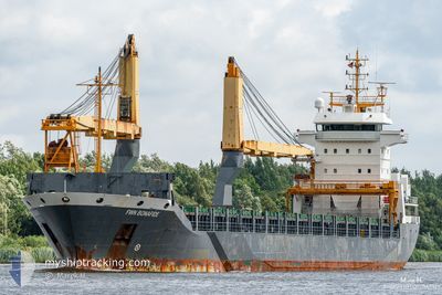
FWN BONAFIDE
General Cargo
Current Trip
| Time Travelled | 2 days |
|---|---|
| Remaining Time | --- |
| Distance Travelled | 32.19 nm |
| Remaining Distance | --- |
| AVG Speed | 12 Knopen |
| MAX Speed | 13 Knopen |
| AVG Wind | 14.5 knots |
| MAX Wind | 17.9 knots |
| MIN Temp | 16.8°C / 62.24°F |
| MAX Temp | 22.5°C / 72.5°F |
| Diepgang | 5.5 M |
| Positie ontvangen | 7 m geleden |
Current Position
| Lengtegraad | -94.58547° |
|---|---|
| Breedtegraat | 29.34071° |
| Status | At anchor |
| Snelheid | |
| Koers | 84° |
| Gebied | Gulf of Mexico |
| Station | T-AIS |
| Positie ontvangen | 7 m geleden |
Info
Information
The current position of FWN BONAFIDE is in Gulf of Mexico with coordinates 29.34071° / -94.58547° as reported on 2024-04-24 22:47 by AIS to our vessel tracker app. The vessel's current speed is 0 Knopen
The vessel FWN BONAFIDE (IMO: 9321108, MMSI: 244850855) is a General Cargo that was built in 2006 ( 18 Jaar oud ). It's sailing under the flag of [NL] Netherlands.
In this page you can find informations about the vessels current position, last detected port calls, and current voyage information. If the vessels is not in coverage by AIS you will find the latest position.
The current position of FWN BONAFIDE is detected by our AIS receivers and we are not responsible for the reliability of the data. The last position was recorded while the vessel was in Coverage by the Ais receivers of our vessel tracking app.
The current draught of FWN BONAFIDE as reported by AIS is 5.5 meters
Weather
| Temperature | 22.4°C / 72.32°F |
|---|---|
| Wind Speed | 12 knots |
| Direction | 119° ESE |
| Pressure | 1017.7 hPa |
| Humidity | 81.2 % |
| Cloud Coverage | --- |
Featured Company
Last Port Calls
| Port | Arrival | Departure | Time In Port |
|---|---|---|---|
| 2024-04-19 12:02 | 2024-04-22 05:57 | 2 d | |
| 2024-04-18 16:12 | 2024-04-19 01:33 | 9 h | |
| 2024-04-11 14:21 | 2024-04-16 13:25 | 4 d | |
| 2024-04-08 05:13 | 2024-04-10 00:40 | 1 d | |
| 2024-04-03 21:31 | 2024-04-06 11:16 | 2 d | |
| 2024-04-01 00:34 | 2024-04-02 19:42 | 1 d | |
| 2024-03-30 01:49 | 2024-03-30 22:26 | 20 h | |
| 2024-03-21 03:49 | 2024-03-24 22:41 | 3 d | |
| 2024-02-23 17:55 | 2024-02-28 16:49 | 4 d | |
| 2024-02-23 17:06 | 2024-02-23 17:34 | 27 m |
Most Visited Ports (Last year)
| Port | Arrivals | |
|---|---|---|
| 8 | ||
| 6 | ||
| 3 | ||
| 2 | ||
| 2 | ||
| 1 |
Last Trips
| Origin | Departure | Destination | Arrival | Distance | |
|---|---|---|---|---|---|
| 2024-04-18 20:33 | 2024-04-19 07:02 | 93.48 nm | |||
| 2024-04-16 08:25 | 2024-04-18 11:12 | 596.70 nm | |||
| 2024-04-09 19:40 | 2024-04-11 09:21 | 282.79 nm | |||
| 2024-04-06 06:16 | 2024-04-08 00:13 | 482.68 nm | |||
| 2024-04-02 14:42 | 2024-04-03 16:31 | 291.03 nm | |||
| 2024-03-30 16:26 | 2024-03-31 19:34 | 246.08 nm | |||
| 2024-03-24 17:41 | 2024-03-29 19:49 | 505.63 nm | |||
| 2024-02-28 16:49 | 2024-03-20 22:49 | 5320.61 nm | |||
| 2024-02-23 17:34 | 2024-02-23 17:55 | 1.39 nm | |||
| 2024-02-17 16:38 | 2024-02-23 17:06 | 420.56 nm |
Events
| Tijd | Evenement | Details | Positie / Bestemming | Info |
|---|---|---|---|---|
| 2024-04-24 22:47 | Status Changed | At anchor Default |
29.34071 / -94.58547
MX VER
|
Snelheid: Koers: 84° |
| 2024-04-24 22:23 | Status Changed | Default At anchor |
29.34077 / -94.58546
MX VER
|
Snelheid: 0.2 kn Koers: 93° |
| 2024-04-24 22:20 | Status Changed | At anchor Default |
29.34082 / -94.58548
MX VER
|
Snelheid: Koers: 92° |
| 2024-04-24 22:17 | Status Changed | Default At anchor |
29.34093 / -94.58543
MX VER
|
Snelheid: Koers: 90° |
| 2024-04-24 21:56 | Status Changed | At anchor Default |
29.34073 / -94.58547
MX VER
|
Snelheid: Koers: 85° |
| 2024-04-24 21:38 | Binnenbereik |
29.34073 / -94.58547
Gulf of Mexico
|
Snelheid: Koers: 353.2° |
|
| 2024-04-22 08:54 | Stop beweging | 10.11 nm, East of BOLIVAR |
29.33930 / -94.58486
MX VER
|
Snelheid: 0.2 kn Koers: 56° |
| 2024-04-22 07:31 | Status Changed | Default Under way using engine |
29.34390 / -94.72794
MX VER
|
Snelheid: 12.3 kn Koers: 86.2° |
| 2024-04-22 07:23 | Buitenbereik |
29.34252 / -94.75456
Gulf of Mexico
MX VER
|
Snelheid: 12.3 kn Koers: 86.2° |
|
| 2024-04-22 05:57 | Vertrekhaven |
|
29.58991 / -94.94011
MX VER
|
Snelheid: 12.5 kn Koers: 144° |