
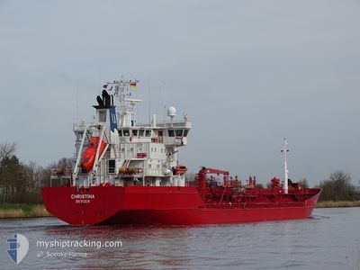
CHRISTINA
Oil/Chemical Tanker
Current Trip
NL AMS VIA NOK
| Time Travelled | 8 h, 6 mins |
|---|---|
| Remaining Time | --- |
| Distance Travelled | 36.60 nm |
| Remaining Distance | --- |
| AVG Speed | 12.7 Knopen |
| MAX Speed | 13.2 Knopen |
| AVG Wind | 9.8 knots |
| MAX Wind | 10.8 knots |
| MIN Temp | -1.3°C / 29.66°F |
| MAX Temp | -0.7°C / 30.74°F |
| Diepgang | 6.3 M |
| Positie ontvangen | 1 h, 0 m geleden |
Current Position
| Lengtegraad | 20.25762° |
|---|---|
| Breedtegraat | 63.16610° |
| Status | Under way using engine |
| Snelheid | 12.9 Knopen |
| Koers | 192.9° |
| Gebied | Gulf of Bothnia |
| Station | T-AIS |
| Positie ontvangen | 1 h, 0 m geleden |
Info
Information
The current position of CHRISTINA is in Gulf of Bothnia with coordinates 63.16610° / 20.25762° as reported on 2024-04-19 04:45 by AIS to our vessel tracker app. The vessel's current speed is 12.9 Knopen
The vessel CHRISTINA (IMO: 9118496, MMSI: 259372000) is a Oil/Chemical Tanker that was built in 1996 ( 28 Jaar oud ). It's sailing under the flag of [NO] Norway.
In this page you can find informations about the vessels current position, last detected port calls, and current voyage information. If the vessels is not in coverage by AIS you will find the latest position.
The current position of CHRISTINA is detected by our AIS receivers and we are not responsible for the reliability of the data. The last position was recorded while the vessel was in Coverage by the Ais receivers of our vessel tracking app.
The current draught of CHRISTINA as reported by AIS is 6.3 meters
Weather
| Temperature | -0.9°C / 30.38°F |
|---|---|
| Wind Speed | 10 knots |
| Direction | 91° E |
| Pressure | 1014 hPa |
| Humidity | 75.2 % |
| Cloud Coverage | 100 % |
Featured Company
Last Port Calls
| Port | Arrival | Departure | Time In Port |
|---|---|---|---|
| 2024-04-17 08:16 | 2024-04-18 21:40 | 1 d | |
| 2024-04-15 18:50 | 2024-04-16 12:47 | 17 h | |
| 2024-04-12 07:35 | 2024-04-13 01:42 | 18 h | |
| 2024-04-10 14:03 | 2024-04-11 05:26 | 15 h | |
| 2024-04-07 05:37 | 2024-04-07 19:09 | 13 h | |
| 2024-03-29 16:37 | 2024-03-31 22:46 | 2 d | |
| 2024-03-27 12:37 | 2024-03-28 02:13 | 13 h | |
| 2024-03-24 18:24 | 2024-03-26 07:40 | 1 d | |
| 2024-03-19 23:32 | 2024-03-20 20:10 | 20 h | |
| 2024-03-14 20:43 | 2024-03-15 07:00 | 10 h |
Most Visited Ports (Last year)
| Port | Arrivals | |
|---|---|---|
| 12 | ||
| 9 | ||
| 9 | ||
| 5 | ||
| 4 | ||
| 4 |
Last Trips
| Origin | Departure | Destination | Arrival | Distance | |
|---|---|---|---|---|---|
| 2024-04-16 14:47 | 2024-04-17 11:16 | 239.59 nm | |||
| 2024-04-13 03:42 | 2024-04-15 20:50 | 819.27 nm | |||
| 2024-04-11 07:26 | 2024-04-12 09:35 | 171.09 nm | |||
| 2024-04-07 22:09 | 2024-04-10 16:03 | 809.41 nm | |||
| 2024-04-01 00:46 | 2024-04-07 08:37 | 1249.55 nm | |||
| 2024-03-28 03:13 | 2024-03-29 17:37 | 396.85 nm | |||
| 2024-03-26 08:40 | 2024-03-27 13:37 | 304.74 nm | |||
| 2024-03-20 21:10 | 2024-03-24 19:24 | 545.74 nm | |||
| 2024-03-15 09:00 | 2024-03-20 00:32 | 1061.74 nm | |||
| 2024-03-14 15:11 | 2024-03-14 22:43 | 93.59 nm |
Events
| Tijd | Evenement | Details | Positie / Bestemming | Info |
|---|---|---|---|---|
| 2024-04-19 04:17 | Wijzig zee gebeid | Finnish part of the Gulf of Bothnia Swedish part of the Gulf of Bothnia |
63.26291 / 20.30609
Gulf of Bothnia
NL AMS VIA NOK
|
Snelheid: 12.8 kn Koers: 191.9° |
| 2024-04-19 04:04 | Wijzig zee gebeid | Swedish part of the Gulf of Bothnia Finnish part of the Gulf of Bothnia |
63.30220 / 20.35594
Gulf of Bothnia
NL AMS VIA NOK
|
Snelheid: 12.9 kn Koers: 218.1° |
| 2024-04-19 03:48 | Gevonden in zee | Finnish part of the Gulf of Bothnia |
63.34731 / 20.43630
Gulf of Bothnia
NL AMS VIA NOK
|
Snelheid: 13 kn Koers: 218.6° |
| 2024-04-19 02:47 | Draught Changed | 6.3 5.6 |
63.53018 / 20.70874
NL AMS VIA NOK
|
Snelheid: 12.3 kn Koers: 206.8° |
| 2024-04-19 02:47 | Destination Changed | NL AMS VIA NOK FI KOK |
63.53018 / 20.70874
NL AMS VIA NOK
|
Snelheid: 12.3 kn Koers: 206.8° |
| 2024-04-19 02:47 | ETA Changed | 2024/04/22 15:00 2024/04/15 17:00 |
63.53018 / 20.70874
NL AMS VIA NOK
|
Snelheid: 12.3 kn Koers: 206.8° |
| 2024-04-19 01:46 | Gevonden in zee | Swedish part of the Gulf of Bothnia |
63.60267 / 21.16352
Gulf of Bothnia
|
Snelheid: 12.7 kn Koers: 245.1° |
| 2024-04-19 01:46 | Binnenbereik |
63.60267 / 21.16352
Gulf of Bothnia
|
Snelheid: 12.7 kn Koers: 245.1° |
|
| 2024-04-18 21:40 | Vertrekhaven |
|
63.60267 / 21.16352
FI KOK
|
Snelheid: Koers: 111° |
| 2024-04-18 13:30 | Buitenbereik |
63.85988 / 23.03829
Gulf of Bothnia
[FI] KOKKOLA
|
Snelheid: Koers: 218° |