
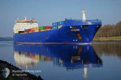
CATHERINE
Ro-Ro Cargo
Current Trip
| Time Travelled | 11 h, 6 mins |
|---|---|
| Remaining Time | 21 h, 28 mins |
| Distance Travelled | 166.91 nm |
| Remaining Distance | 324.20 nm |
| AVG Speed | 14.9 Knopen |
| MAX Speed | 19.4 Knopen |
| AVG Wind | 13.9 knots |
| MAX Wind | 21 knots |
| MIN Temp | 3.9°C / 39.02°F |
| MAX Temp | 9°C / 48.2°F |
| Diepgang | 7.2 M |
| Positie ontvangen | Nu |
Current Position
| Lengtegraad | -0.70528° |
|---|---|
| Breedtegraat | 50.46055° |
| Status | Under way using engine |
| Snelheid | 15.2 Knopen |
| Koers | 260.4° |
| Gebied | English Channel |
| Station | T-AIS |
| Positie ontvangen | Nu |
Info
Information
The current position of CATHERINE is in English Channel with coordinates 50.46055° / -0.70528° as reported on 2024-04-25 01:16 by AIS to our vessel tracker app. The vessel's current speed is 15.2 Knopen and is heading at the port of CORK. The estimated time of arrival as calculated by MyShipTracking vessel tracking app is 2024-04-25 22:45 LT
The vessel CATHERINE (IMO: 9209453, MMSI: 249107000) is a Ro-Ro Cargo that was built in 2002 ( 22 Jaar oud ). It's sailing under the flag of [MT] Malta.
In this page you can find informations about the vessels current position, last detected port calls, and current voyage information. If the vessels is not in coverage by AIS you will find the latest position.
The current position of CATHERINE is detected by our AIS receivers and we are not responsible for the reliability of the data. The last position was recorded while the vessel was in Coverage by the Ais receivers of our vessel tracking app.
The current draught of CATHERINE as reported by AIS is 7.2 meters
Weather
| Temperature | 9°C / 48.2°F |
|---|---|
| Wind Speed | 2 knots |
| Direction | 136° SE |
| Pressure | 1011.4 hPa |
| Humidity | 52.6 % |
| Cloud Coverage | 100 % |
Featured Company
Last Port Calls
| Port | Arrival | Departure | Time In Port |
|---|---|---|---|
| 2024-04-24 05:09 | 2024-04-24 14:11 | 9 h | |
| 2024-04-22 05:09 | 2024-04-22 18:25 | 13 h | |
| 2024-04-22 04:52 | 2024-04-22 05:05 | 12 m | |
| 2024-04-18 06:06 | 2024-04-20 05:52 | 1 d | |
| 2024-04-16 05:21 | 2024-04-16 16:28 | 11 h | |
| 2024-04-16 05:07 | 2024-04-16 05:18 | 10 m | |
| 2024-04-14 06:03 | 2024-04-14 14:42 | 8 h | |
| 2024-04-12 12:02 | 2024-04-12 20:13 | 8 h | |
| 2024-04-12 11:50 | 2024-04-12 11:59 | 9 m | |
| 2024-04-10 18:36 | 2024-04-11 01:22 | 6 h |
Last Trips
| Origin | Departure | Destination | Arrival | Distance | |
|---|---|---|---|---|---|
| 2024-04-22 19:25 | 2024-04-24 07:09 | 528.24 nm | |||
| 2024-04-22 06:05 | 2024-04-22 06:09 | 0.73 nm | |||
| 2024-04-20 07:52 | 2024-04-22 05:52 | 560.12 nm | |||
| 2024-04-16 17:28 | 2024-04-18 08:06 | 528.05 nm | |||
| 2024-04-16 06:18 | 2024-04-16 06:21 | 0.59 nm | |||
| 2024-04-14 16:42 | 2024-04-16 06:07 | 521.51 nm | |||
| 2024-04-12 21:13 | 2024-04-14 08:03 | 529.77 nm | |||
| 2024-04-12 12:59 | 2024-04-12 13:02 | 0.80 nm | |||
| 2024-04-11 03:22 | 2024-04-12 12:50 | 522.09 nm | |||
| 2024-04-09 10:13 | 2024-04-10 20:36 | 526.61 nm |
Events
| Tijd | Evenement | Details | Positie / Bestemming | Info |
|---|---|---|---|---|
| 2024-04-24 21:42 | Status Changed | Under way using engine Default |
50.66093 / .61753
IEORK
|
Snelheid: 14.5 kn Koers: 236° |
| 2024-04-24 21:40 | Status Changed | Default Under way using engine |
50.66501 / .62613
IEORK
|
Snelheid: 14.7 kn Koers: 232.6° |
| 2024-04-24 19:19 | Start beweging | 4.86 nm, South East of DOVER |
51.06589 / 1.42298
IEORK
|
Snelheid: 18.4 kn Koers: 228.3° |
| 2024-04-24 19:18 | Stop beweging | 4.88 nm, South East of DOVER |
51.06722 / 1.42542
IEORK
|
Snelheid: Koers: 0° |
| 2024-04-24 19:14 | Wijzig zee gebeid | United Kingdom part of the English Channel United Kingdom part of the North Sea |
51.08158 / 1.45612
English Channel
IEORK
|
Snelheid: 18.5 kn Koers: 237° |
| 2024-04-24 18:45 | Start beweging | 12.36 nm, East of DOVER |
51.15973 / 1.64936
IEORK
|
Snelheid: 14.4 kn Koers: 240.6° |
| 2024-04-24 18:45 | Stop beweging | 12.47 nm, East of DOVER |
51.16076 / 1.65207
IEORK
|
Snelheid: Koers: 0° |
| 2024-04-24 18:24 | Start beweging | 14.3 nm, South East of RAMSGATE |
51.23047 / 1.76912
IEORK
|
Snelheid: 17.5 kn Koers: 221.8° |
| 2024-04-24 18:23 | Stop beweging | 14.34 nm, South East of RAMSGATE |
51.23186 / 1.77112
IEORK
|
Snelheid: Koers: 0° |
| 2024-04-24 18:20 | Start beweging | 14.66 nm, East of RAMSGATE |
51.24497 / 1.78844
IEORK
|
Snelheid: 17.5 kn Koers: 215.9° |