
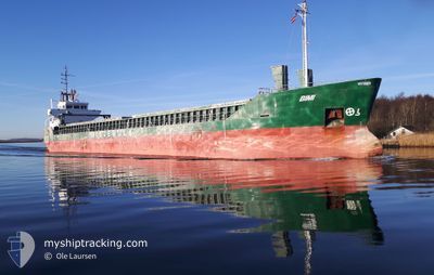
BIMI
General Cargo
Current Trip
| Time Travelled | 17 h, 26 mins |
|---|---|
| Remaining Time | 4 h, 34 mins |
| Distance Travelled | 168.12 nm |
| Remaining Distance | 47.07 nm |
| AVG Speed | 9.9 Knopen |
| MAX Speed | 12.2 Knopen |
| AVG Wind | 19.9 knots |
| MAX Wind | 26.8 knots |
| MIN Temp | 7.8°C / 46.04°F |
| MAX Temp | 10.4°C / 50.72°F |
| Diepgang | 3.3 M |
| Positie ontvangen | Nu |
Current Position
| Lengtegraad | 2.95648° |
|---|---|
| Breedtegraat | 51.86632° |
| Status | Under way using engine |
| Snelheid | 10.3 Knopen |
| Koers | 119.6° |
| Gebied | North Sea |
| Station | T-AIS |
| Positie ontvangen | Nu |
Info
Information
The current position of BIMI is in North Sea with coordinates 51.86632° / 2.95648° as reported on 2024-04-19 07:08 by AIS to our vessel tracker app. The vessel's current speed is 10.3 Knopen and is heading at the port of TERNEUZEN. The estimated time of arrival as calculated by MyShipTracking vessel tracking app is 2024-04-19 11:43 LT
The vessel BIMI (IMO: 8914295, MMSI: 258681000) is a General Cargo that was built in 1991 ( 33 Jaar oud ). It's sailing under the flag of [NO] Norway.
In this page you can find informations about the vessels current position, last detected port calls, and current voyage information. If the vessels is not in coverage by AIS you will find the latest position.
The current position of BIMI is detected by our AIS receivers and we are not responsible for the reliability of the data. The last position was recorded while the vessel was in Coverage by the Ais receivers of our vessel tracking app.
The current draught of BIMI as reported by AIS is 3.3 meters
Weather
| Temperature | 10°C / 50°F |
|---|---|
| Wind Speed | 25 knots |
| Direction | 295° WNW |
| Pressure | 1011.3 hPa |
| Humidity | 82.4 % |
| Cloud Coverage | 100 % |
Featured Company
Last Port Calls
| Port | Arrival | Departure | Time In Port |
|---|---|---|---|
| 2024-04-16 12:39 | 2024-04-18 13:43 | 2 d | |
| 2024-04-14 06:21 | 2024-04-14 16:57 | 10 h | |
| 2024-04-11 05:17 | 2024-04-11 19:24 | 14 h | |
| 2024-04-11 04:06 | 2024-04-11 04:17 | 11 m | |
| 2024-04-05 21:23 | 2024-04-07 21:13 | 1 d | |
| 2024-04-04 20:49 | 2024-04-05 17:56 | 21 h | |
| 2024-03-27 08:30 | 2024-03-30 13:18 | 3 d | |
| 2024-03-22 05:36 | 2024-03-23 16:46 | 1 d | |
| 2024-03-19 23:51 | 2024-03-20 13:45 | 13 h | |
| 2024-03-18 03:19 | 2024-03-19 00:55 | 21 h |
Last Trips
| Origin | Departure | Destination | Arrival | Distance | |
|---|---|---|---|---|---|
| 2024-04-14 18:57 | 2024-04-16 13:39 | 218.24 nm | |||
| 2024-04-11 21:24 | 2024-04-14 08:21 | 97.47 nm | |||
| 2024-04-11 06:17 | 2024-04-11 07:17 | 7.01 nm | |||
| 2024-04-07 22:13 | 2024-04-11 06:06 | 674.16 nm | |||
| 2024-04-05 18:56 | 2024-04-05 22:23 | 33.68 nm | |||
| 2024-03-30 14:18 | 2024-04-04 21:49 | 997.39 nm | |||
| 2024-03-23 16:46 | 2024-03-27 09:30 | 778.86 nm | |||
| 2024-03-20 14:45 | 2024-03-22 05:36 | 277.15 nm | |||
| 2024-03-19 01:55 | 2024-03-20 00:51 | 89.94 nm | |||
| 2024-03-15 00:49 | 2024-03-18 04:19 | 655.43 nm |
Events
| Tijd | Evenement | Details | Positie / Bestemming | Info |
|---|---|---|---|---|
| 2024-04-19 05:46 | Gevonden in zee | Dutch part of the North Sea |
52.00763 / 2.65638
North Sea
GHENT
|
Snelheid: 10.5 kn Koers: 134.4° |
| 2024-04-19 05:04 | Binnenbereik |
52.08953 / 2.51632
North Sea
GHENT
|
Snelheid: 10.6 kn Koers: 134.1° |
|
| 2024-04-19 03:45 | Buitenbereik |
52.27407 / 2.28729
North Sea
GHENT
|
Snelheid: 10.6 kn Koers: 151.2° |
|
| 2024-04-18 19:40 | Binnenbereik |
53.13394 / .91889
North Sea
GHENT
|
Snelheid: 9.5 kn Koers: 132.5° |
|
| 2024-04-18 16:02 | Buitenbereik |
53.54223 / .19912
North Sea
GHENT
|
Snelheid: 11.7 kn Koers: 88.9° |
|
| 2024-04-18 13:43 | Vertrekhaven |
|
53.71270 / -.35747
GHENT
|
Snelheid: 8.9 kn Koers: 64° |
| 2024-04-18 13:41 | Start beweging |
53.71065 / -.36498
[GB] NEW HOLLAND
|
Snelheid: 6.1 kn Koers: 69° |
|
| 2024-04-18 13:28 | Status Changed | Under way using engine Moored |
53.70900 / -.36528
[GB] NEW HOLLAND
|
Snelheid: Koers: 248° |
| 2024-04-18 12:31 | Draught Changed | 3.3 3.2 |
53.70899 / -.36528
[GB] NEW HOLLAND
|
Snelheid: Koers: 247° |
| 2024-04-18 06:30 | ETA Changed | 2024/04/19 08:00 2024/04/19 06:00 |
53.70899 / -.36528
[GB] NEW HOLLAND
|
Snelheid: Koers: 248° |