
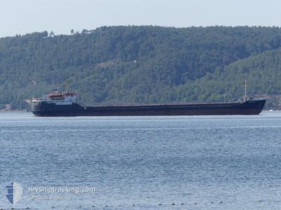
BELFAST
General Cargo
Current Trip
| Time Travelled | 18 days |
|---|---|
| Remaining Time | --- |
| Distance Travelled | 1253.11 nm |
| Remaining Distance | --- |
| AVG Speed | 8.5 Knopen |
| MAX Speed | 8.5 Knopen |
| AVG Wind | 9.1 knots |
| MAX Wind | 27 knots |
| MIN Temp | 17.3°C / 63.14°F |
| MAX Temp | 28.3°C / 82.94°F |
| Diepgang | 2.8 M |
| Positie ontvangen | 16 d geleden |
Current Position
| Lengtegraad | --- |
|---|---|
| Breedtegraat | --- |
| Status | Under way using engine |
| Snelheid | 6.6 Knopen |
| Koers | 92.6° |
| Gebied | Black Sea |
| Station | T-AIS |
| Positie ontvangen | 16 d geleden |
Info
Information
The current position of BELFAST is in Black Sea with coordinates 41.28792° / 29.99142° as reported on 2024-09-12 21:05 by AIS to our vessel tracker app. The vessel's current speed is 6.6 Knopen and is heading at the port of ROSTOV-ON-DON. The estimated time of arrival as calculated by MyShipTracking vessel tracking app is 2024-09-18 12:00 LT
The vessel BELFAST (IMO: 8035166, MMSI: 677073600) is a General Cargo that was built in 1982 ( 42 Jaar oud ). It's sailing under the flag of [TZ] Tanzania.
In this page you can find informations about the vessels current position, last detected port calls, and current voyage information. If the vessels is not in coverage by AIS you will find the latest position.
The current position of BELFAST is detected by our AIS receivers and we are not responsible for the reliability of the data. The last position was recorded while the vessel was in Coverage by the Ais receivers of our vessel tracking app.
The current draught of BELFAST as reported by AIS is 2.8 meters
Weather
| Temperature | 20.1°C / 68.18°F |
|---|---|
| Wind Speed | 11 knots |
| Direction | 73° ENE |
| Pressure | 1019.2 hPa |
| Humidity | 64.4 % |
| Cloud Coverage | --- |
Featured Company
Events
| Tijd | Evenement | Details | Positie / Bestemming | Info |
|---|---|---|---|---|
| 2024-09-28 03:48 | Start beweging | 3.23 nm, West of MARIUPOL |
47.06723 / 37.44514
RU ROV
|
Snelheid: 44.1 kn Koers: 24° |
| 2024-09-28 03:41 | Stop beweging | 3.26 nm, West of MARIUPOL |
47.07774 / 37.44745
RU ROV
|
Snelheid: 0.1 kn Koers: 22° |
| 2024-09-28 03:28 | Start beweging | 3.07 nm, West of MARIUPOL |
47.07058 / 37.44976
RU ROV
|
Snelheid: 53.7 kn Koers: 30° |
| 2024-09-28 03:21 | Stop beweging | 3.21 nm, West of MARIUPOL |
47.07825 / 37.44888
RU ROV
|
Snelheid: 0.1 kn Koers: 20° |
| 2024-09-28 03:04 | Start beweging | 3.17 nm, West of MARIUPOL |
47.07105 / 37.44739
RU ROV
|
Snelheid: 59.6 kn Koers: 28° |
| 2024-09-28 03:01 | Stop beweging | 3.32 nm, West of MARIUPOL |
47.07674 / 37.44561
RU ROV
|
Snelheid: Koers: 22° |
| 2024-09-28 02:48 | Start beweging | 3.15 nm, West of MARIUPOL |
47.07209 / 37.44828
RU ROV
|
Snelheid: 59.5 kn Koers: 28° |
| 2024-09-28 02:41 | Stop beweging | 3.32 nm, West of MARIUPOL |
47.07662 / 37.44557
RU ROV
|
Snelheid: Koers: 23° |
| 2024-09-28 02:18 | Start beweging | 3.23 nm, West of MARIUPOL |
47.06844 / 37.44552
RU ROV
|
Snelheid: 54 kn Koers: 30° |
| 2024-09-27 04:47 | Start beweging |
45.82375 / 36.69267
RU ROV
|
Snelheid: 53.6 kn Koers: 240° |