
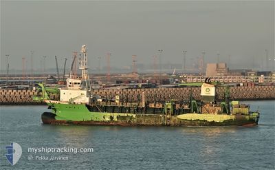
ARTEVELDE
Trailing Suction Hopper Dredger
Current Trip
| Time Travelled | 1 day |
|---|---|
| Remaining Time | --- |
| Distance Travelled | 81.14 nm |
| Remaining Distance | --- |
| AVG Speed | 8.7 Knopen |
| MAX Speed | 13 Knopen |
| AVG Wind | 19.8 knots |
| MAX Wind | 24.9 knots |
| MIN Temp | 6.3°C / 43.34°F |
| MAX Temp | 16.3°C / 61.34°F |
| Diepgang | 6 M |
| Positie ontvangen | 6 h, 4 m geleden |
Current Position
| Lengtegraad | 3.07930° |
|---|---|
| Breedtegraat | 43.01888° |
| Status | Restricted manoeuverability |
| Snelheid | 0.9 Knopen |
| Koers | 350° |
| Gebied | Mediterranean Sea - Western Basin |
| Station | T-AIS |
| Positie ontvangen | 6 h, 4 m geleden |
Info
Information
The current position of ARTEVELDE is in Mediterranean Sea - Western Basin with coordinates 43.01888° / 3.07930° as reported on 2024-04-25 07:35 by AIS to our vessel tracker app. The vessel's current speed is 0.9 Knopen
The vessel ARTEVELDE (IMO: 9501954, MMSI: 205557000) is a Trailing Suction Hopper Dredger that was built in 2009 ( 15 Jaar oud ). It's sailing under the flag of [BE] Belgium.
In this page you can find informations about the vessels current position, last detected port calls, and current voyage information. If the vessels is not in coverage by AIS you will find the latest position.
The current position of ARTEVELDE is detected by our AIS receivers and we are not responsible for the reliability of the data. The last position was recorded while the vessel was in Coverage by the Ais receivers of our vessel tracking app.
The current draught of ARTEVELDE as reported by AIS is 6 meters
Weather
| Temperature | 16.8°C / 62.24°F |
|---|---|
| Wind Speed | --- |
| Direction | 251° WSW |
| Pressure | 1008.3 hPa |
| Humidity | 47.1 % |
| Cloud Coverage | 62 % |
Featured Company
Last Port Calls
| Port | Arrival | Departure | Time In Port |
|---|---|---|---|
| 2024-04-23 19:19 | 2024-04-23 19:41 | 22 m | |
| 2024-04-17 19:31 | 2024-04-17 19:40 | 9 m | |
| 2024-04-17 06:20 | 2024-04-17 17:30 | 11 h | |
| 2024-03-29 19:51 | 2024-03-30 17:27 | 21 h | |
| 2024-03-28 19:30 | 2024-03-29 12:14 | 16 h | |
| 2024-03-27 22:06 | 2024-03-28 11:12 | 13 h | |
| 2024-02-08 06:47 | 2024-03-27 07:25 | ||
| 2024-02-05 18:54 | 2024-02-07 10:46 | 1 d | |
| 2024-02-05 00:01 | 2024-02-05 00:53 | 52 m | |
| 2024-02-04 02:49 | 2024-02-04 03:16 | 27 m |
Most Visited Ports (Last year)
| Port | Arrivals | |
|---|---|---|
| 399 | ||
| 335 | ||
| 32 | ||
| 15 | ||
| 3 | ||
| 2 |
Last Trips
| Origin | Departure | Destination | Arrival | Distance | |
|---|---|---|---|---|---|
| 2024-04-17 21:40 | 2024-04-23 21:19 | 254.29 nm | |||
| 2024-04-17 19:30 | 2024-04-17 21:31 | 2.13 nm | |||
| 2024-03-30 18:27 | 2024-04-17 08:20 | 2113.07 nm | |||
| 2024-03-29 13:14 | 2024-03-29 20:51 | 23.26 nm | |||
| 2024-03-28 12:12 | 2024-03-28 20:30 | 62.56 nm | |||
| 2024-03-27 08:25 | 2024-03-27 23:06 | 66.69 nm | |||
| 2024-02-07 11:46 | 2024-02-08 07:47 | 17.62 nm | |||
| 2024-02-05 01:53 | 2024-02-05 19:54 | 22.42 nm | |||
| 2024-02-04 04:16 | 2024-02-05 01:01 | 51.81 nm | |||
| 2024-02-04 01:39 | 2024-02-04 03:49 | 2.91 nm |
Events
| Tijd | Evenement | Details | Positie / Bestemming | Info |
|---|---|---|---|---|
| 2024-04-25 09:57 | Start beweging | 1.52 nm, South East of PORT LA NOUVELLE |
43.00834 / 3.08833
FRNOU
|
Snelheid: 9 kn Koers: 83° |
| 2024-04-25 07:59 | Status Changed | Default Restricted manoeuverability |
43.02167 / 3.07667
FRNOU
|
Snelheid: 0.9 kn Koers: 350° |
| 2024-04-25 07:35 | Buitenbereik |
43.01888 / 3.07930
Mediterranean Sea - Western Basin
|
Snelheid: 0.9 kn Koers: 331.9° |
|
| 2024-04-25 07:35 | Stop beweging | 0.97 nm, East of PORT LA NOUVELLE |
43.01881 / 3.07934
FRNOU
|
Snelheid: Koers: 350° |
| 2024-04-25 07:21 | Start beweging | 1.85 nm, East of PORT LA NOUVELLE |
43.00856 / 3.09650
FRNOU
|
Snelheid: 4.9 kn Koers: 257° |
| 2024-04-25 07:15 | Stop beweging | 2 nm, East of PORT LA NOUVELLE |
43.00879 / 3.10020
FRNOU
|
Snelheid: Koers: 310° |
| 2024-04-25 07:02 | Start beweging | 2.35 nm, East of PORT LA NOUVELLE |
43.01560 / 3.11040
FRNOU
|
Snelheid: 3.9 kn Koers: 224° |
| 2024-04-25 06:52 | Stop beweging | 2.4 nm, East of PORT LA NOUVELLE |
43.01729 / 3.11162
FRNOU
|
Snelheid: Koers: 297° |
| 2024-04-25 06:41 | Start beweging | 1.29 nm, South East of PORT LA NOUVELLE |
43.00894 / 3.08262
FRNOU
|
Snelheid: 3.9 kn Koers: 122° |
| 2024-04-25 04:16 | Stop beweging | 0.98 nm, East of PORT LA NOUVELLE |
43.01818 / 3.07938
FRNOU
|
Snelheid: Koers: 351° |