
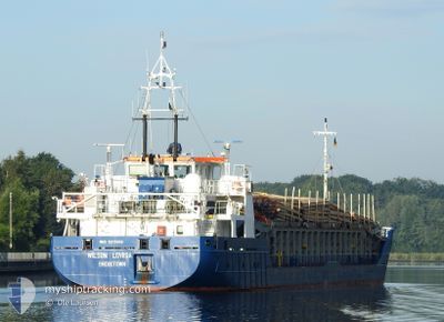
WILSON LOVIISA
General Cargo
Current Trip
| Time Travelled | 1 day |
|---|---|
| Remaining Time | 2 days |
| Distance Travelled | 181.14 nm |
| Remaining Distance | 544.83 nm |
| AVG Speed | 6.9 Noeuds |
| MAX Speed | 9.9 Noeuds |
| AVG Wind | 18.9 knots |
| MAX Wind | 20.9 knots |
| MIN Temp | 6.8°C / 44.24°F |
| MAX Temp | 8.9°C / 48.02°F |
| Tirant d eau | 4.6 m |
| Position reçue | 5 h, 1 m depuis |
Current Position
| Longitude | 5.78129° |
|---|---|
| Latitude | 53.62244° |
| Etat | Under way using engine |
| Vitesse | 9.2 Noeuds |
| Parcours | 71.9° |
| Zone | North Sea |
| Station | T-AIS |
| Position reçue | 5 h, 1 m depuis |
Info
Information
The current position of WILSON LOVIISA is in North Sea with coordinates 53.62244° / 5.78129° as reported on 2024-04-25 10:51 by AIS to our vessel tracker app. The vessel's current speed is 9.2 Noeuds and is heading at the port of KLAIPEDA. The estimated time of arrival as calculated by MyShipTracking vessel tracking app is 2024-04-28 11:38 LT
The vessel WILSON LOVIISA (IMO: 9213600, MMSI: 314608000) is a General Cargo that was built in 2005 ( 19 Age ). It's sailing under the flag of [BB] Barbados.
In this page you can find informations about the vessels current position, last detected port calls, and current voyage information. If the vessels is not in coverage by AIS you will find the latest position.
The current position of WILSON LOVIISA is detected by our AIS receivers and we are not responsible for the reliability of the data. The last position was recorded while the vessel was in Coverage by the Ais receivers of our vessel tracking app.
The current draught of WILSON LOVIISA as reported by AIS is 4.6 meters
Weather
| Temperature | 6.9°C / 44.42°F |
|---|---|
| Wind Speed | 3 knots |
| Direction | 191° S |
| Pressure | 1002.1 hPa |
| Humidity | 72.7 % |
| Cloud Coverage | 100 % |
Featured Company
Last Port Calls
| Port | Arrival | Departure | Time In Port |
|---|---|---|---|
| 2024-04-23 04:39 | 2024-04-24 11:15 | 1 d | |
| 2024-04-19 01:37 | 2024-04-20 02:03 | 1 d | |
| 2024-04-07 16:41 | 2024-04-09 18:52 | 2 d | |
| 2024-04-05 22:48 | 2024-04-05 23:32 | 44 m | |
| 2024-04-04 13:39 | 2024-04-05 16:37 | 1 d | |
| 2024-04-04 08:02 | 2024-04-04 08:21 | 18 m | |
| 2024-03-30 00:58 | 2024-03-30 17:25 | 16 h | |
| 2024-03-25 19:30 | 2024-03-28 19:42 | 3 d | |
| 2024-03-19 20:31 | 2024-03-22 00:09 | 2 d | |
| 2024-03-13 22:14 | 2024-03-14 15:17 | 17 h |
Last Trips
| Origin | Departure | Destination | Arrival | Distance | |
|---|---|---|---|---|---|
| 2024-04-20 04:03 | 2024-04-23 06:39 | 680.29 nm | |||
| 2024-04-09 21:52 | 2024-04-19 03:37 | 1740.08 nm | |||
| 2024-04-06 01:32 | 2024-04-07 19:41 | 348.69 nm | |||
| 2024-04-05 18:37 | 2024-04-06 00:48 | 49.22 nm | |||
| 2024-04-04 10:21 | 2024-04-04 15:39 | 48.86 nm | |||
| 2024-03-30 18:25 | 2024-04-04 10:02 | 858.85 nm | |||
| 2024-03-28 19:42 | 2024-03-30 01:58 | 261.80 nm | |||
| 2024-03-22 01:09 | 2024-03-25 19:30 | 658.50 nm | |||
| 2024-03-14 16:17 | 2024-03-19 21:31 | 502.14 nm | |||
| 2024-03-11 20:30 | 2024-03-13 23:14 | 409.96 nm |
Events
| Heure | Evenement | Détails | Position/ Destination | Info |
|---|---|---|---|---|
| 2024-04-25 10:56 | Etat Changé | Default Under way using engine |
53.62702 / 5.80292
NLVLI>>LT KLJ
|
Vitesse: 9.2 kn Parcours: 71.9° |
| 2024-04-25 10:51 | Hors de la zone couverte |
53.62244 / 5.78129
North Sea
NLVLI>>LT KLJ
|
Vitesse: 9.2 kn Parcours: 71.9° |
|
| 2024-04-25 06:59 | Changement de destination | NLVLI>>LT KLJ LT KLJ |
53.40877 / 4.80120
NLVLI>>LT KLJ
|
Vitesse: 9.7 kn Parcours: 67.2° |
| 2024-04-25 06:43 | Etat Changé | Under way using engine Default |
53.39194 / 4.73694
LT KLJ
|
Vitesse: 9 kn Parcours: 29° |
| 2024-04-25 06:43 | Dans la zone couverte |
53.39254 / 4.73980
North Sea
LT KLJ
|
Vitesse: 9.1 kn Parcours: 73.2° |
|
| 2024-04-25 04:03 | Etat Changé | Default Under way using engine |
53.01833 / 4.39167
LT KLJ
|
Vitesse: 9.7 kn Parcours: 25.8° |
| 2024-04-25 04:00 | Etat Changé | Under way using engine Default |
53.01040 / 4.38568
LT KLJ
|
Vitesse: 9 kn Parcours: 22° |
| 2024-04-25 04:00 | Hors de la zone couverte |
53.01040 / 4.38568
North Sea
LT KLJ
|
Vitesse: 9.7 kn Parcours: 25.8° |
|
| 2024-04-25 03:45 | Etat Changé | Default Under way using engine |
52.97333 / 4.35833
LT KLJ
|
Vitesse: 9.5 kn Parcours: 20.6° |
| 2024-04-25 03:37 | Etat Changé | Under way using engine Default |
52.95511 / 4.34627
LT KLJ
|
Vitesse: 9 kn Parcours: 22° |