
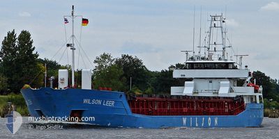
WILSON LEER
General Cargo
Current Trip
| Time Travelled | 7 days |
|---|---|
| Remaining Time | --- |
| Distance Travelled | 1393.44 nm |
| Remaining Distance | --- |
| AVG Speed | 9 Noeuds |
| MAX Speed | 12.3 Noeuds |
| AVG Wind | 12 knots |
| MAX Wind | 35.8 knots |
| MIN Temp | 10.2°C / 50.36°F |
| MAX Temp | 17.6°C / 63.68°F |
| Tirant d eau | 6 m |
| Position reçue | 4 h, 27 m depuis |
Current Position
| Longitude | -6.38489° |
|---|---|
| Latitude | 35.89759° |
| Etat | Under way using engine |
| Vitesse | 2.8 Noeuds |
| Parcours | 100° |
| Zone | North Atlantic Ocean |
| Station | T-AIS |
| Position reçue | 4 h, 27 m depuis |
Info
Information
The current position of WILSON LEER is in North Atlantic Ocean with coordinates 35.89759° / -6.38489° as reported on 2024-04-19 18:34 by AIS to our vessel tracker app. The vessel's current speed is 2.8 Noeuds and is heading at the port of CORINTHOS. The estimated time of arrival as calculated by MyShipTracking vessel tracking app is 2024-04-25 17:00 LT
The vessel WILSON LEER (IMO: 9150482, MMSI: 314552000) is a General Cargo that was built in 1996 ( 28 Age ). It's sailing under the flag of [BB] Barbados.
In this page you can find informations about the vessels current position, last detected port calls, and current voyage information. If the vessels is not in coverage by AIS you will find the latest position.
The current position of WILSON LEER is detected by our AIS receivers and we are not responsible for the reliability of the data. The last position was recorded while the vessel was in Coverage by the Ais receivers of our vessel tracking app.
The current draught of WILSON LEER as reported by AIS is 6 meters
Weather
| Temperature | 16.5°C / 61.7°F |
|---|---|
| Wind Speed | 30 knots |
| Direction | 102° ESE |
| Pressure | 1013.8 hPa |
| Humidity | 78.9 % |
| Cloud Coverage | 100 % |
Featured Company
Last Port Calls
| Port | Arrival | Departure | Time In Port |
|---|---|---|---|
| 2024-04-11 00:49 | 2024-04-12 18:51 | 1 d | |
| 2024-04-09 17:56 | 2024-04-10 22:04 | 1 d | |
| 2024-04-04 13:44 | 2024-04-08 04:35 | 3 d | |
| 2024-03-30 22:56 | 2024-04-03 04:43 | 3 d | |
| 2024-03-28 17:10 | 2024-03-30 07:51 | 1 d | |
| 2024-03-27 06:31 | 2024-03-28 17:04 | 1 d | |
| 2024-03-27 05:42 | 2024-03-27 06:12 | 29 m | |
| 2024-03-24 13:43 | 2024-03-27 02:38 | 2 d | |
| 2024-03-21 16:34 | 2024-03-23 16:40 | 2 d | |
| 2024-02-24 13:02 | 2024-02-28 12:39 | 3 d |
Most Visited Ports (Last year)
| Port | Arrivals | |
|---|---|---|
| 5 | ||
| 4 | ||
| 3 | ||
| 3 | ||
| 2 | ||
| 2 |
Last Trips
| Origin | Departure | Destination | Arrival | Distance | |
|---|---|---|---|---|---|
| 2024-04-11 00:04 | 2024-04-11 02:49 | 30.89 nm | |||
| 2024-04-08 05:35 | 2024-04-09 19:56 | 281.01 nm | |||
| 2024-04-03 05:43 | 2024-04-04 14:44 | 113.72 nm | |||
| 2024-03-30 07:51 | 2024-03-30 22:56 | 107.84 nm | |||
| 2024-03-28 17:04 | 2024-03-28 17:10 | 0.63 nm | |||
| 2024-03-27 06:12 | 2024-03-27 06:31 | 1.24 nm | |||
| 2024-03-27 02:38 | 2024-03-27 05:42 | 27.80 nm | |||
| 2024-03-23 16:40 | 2024-03-24 13:43 | 160.55 nm | |||
| 2024-02-28 13:39 | 2024-03-21 16:34 | 2108.29 nm | |||
| 2024-02-20 23:11 | 2024-02-24 14:02 | 214.25 nm |
Events
| Heure | Evenement | Détails | Position/ Destination | Info |
|---|---|---|---|---|
| 2024-04-19 18:41 | Etat Changé | Default Under way using engine |
35.89620 / -6.37522
GR KRT
|
Vitesse: 2.8 kn Parcours: 100° |
| 2024-04-19 18:34 | Hors de la zone couverte |
35.89759 / -6.38489
North Atlantic Ocean
GR KRT
|
Vitesse: 2.8 kn Parcours: 95.1° |
|
| 2024-04-19 18:12 | Etat Changé | Under way using engine Default |
35.90156 / -6.41189
GR KRT
|
Vitesse: 3.8 kn Parcours: 97° |
| 2024-04-19 17:55 | Etat Changé | Default Under way using engine |
35.90304 / -6.42462
GR KRT
|
Vitesse: 3.1 kn Parcours: 101° |
| 2024-04-19 17:52 | Etat Changé | Under way using engine Default |
35.90348 / -6.43111
GR KRT
|
Vitesse: 3.5 kn Parcours: 107° |
| 2024-04-19 17:46 | Etat Changé | Default Under way using engine |
35.90442 / -6.43481
GR KRT
|
Vitesse: 3 kn Parcours: 104° |
| 2024-04-19 17:37 | Detecté en mer | Moroccan part of the North Atlantic Ocean |
35.90716 / -6.44640
North Atlantic Ocean
GR KRT
|
Vitesse: 3 kn Parcours: 104.4° |
| 2024-04-19 11:51 | Etat Changé | Under way using engine Default |
35.99035 / -6.78935
GR KRT
|
Vitesse: 3.2 kn Parcours: 106° |
| 2024-04-19 11:42 | Etat Changé | Default Under way using engine |
35.99062 / -6.79060
GR KRT
|
Vitesse: 3.6 kn Parcours: 106° |
| 2024-04-19 05:26 | Detecté en mer | Spanish part of the North Atlantic Ocean |
36.14338 / -7.44540
North Atlantic Ocean
GR KRT
|
Vitesse: 8.3 kn Parcours: 106.6° |